Kinsley Mountain Topo Map Nevada
To zoom in, hover over the map of Kinsley Mountain
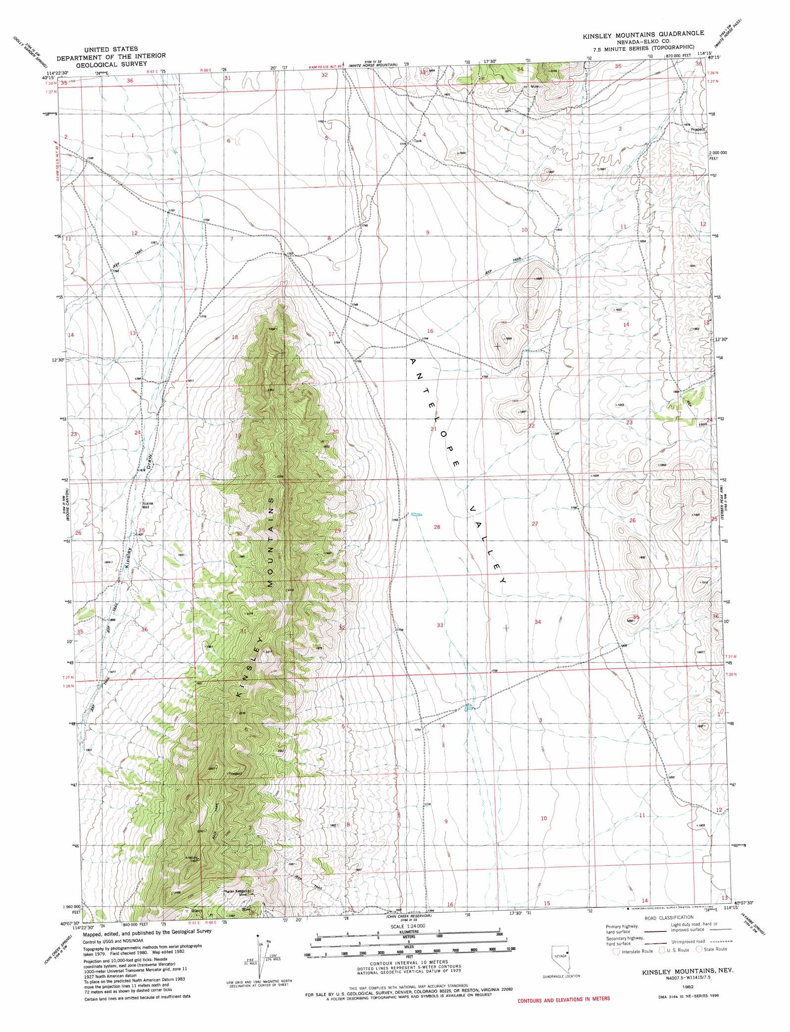
USGS Topo Quad 40114b3 - 1:24,000 scale
| Topo Map Name: | Kinsley Mountain |
| USGS Topo Quad ID: | 40114b3 |
| Print Size: | ca. 21 1/4" wide x 27" high |
| Southeast Coordinates: | 40.125° N latitude / 114.25° W longitude |
| Map Center Coordinates: | 40.1875° N latitude / 114.3125° W longitude |
| U.S. State: | NV |
| Filename: | o40114b3.jpg |
| Download Map JPG Image: | Kinsley Mountain topo map 1:24,000 scale |
| Map Type: | Topographic |
| Topo Series: | 7.5´ |
| Map Scale: | 1:24,000 |
| Source of Map Images: | United States Geological Survey (USGS) |
| Alternate Map Versions: |
Kinsley Mountains NV 1982, updated 1982 Download PDF Buy paper map Kinsley Mountains NV 2012 Download PDF Buy paper map Kinsley Mountains NV 2015 Download PDF Buy paper map |
1:24,000 Topo Quads surrounding Kinsley Mountain
Mizpah Point |
White Horse Mountain Nw |
Goshute Peak |
Ferguson Mountain |
Ferguson Flat |
Sharp Peak |
Dolly Varden Spring |
White Horse Mountain |
White Horse Pass |
Utah Peak |
Goshute Lake Ne |
Boone Canyon |
Kinsley Mountain |
Ferber Peak Nw |
Ferber Peak |
Lages Station |
Chin Creek Spring |
Chin Creek Reservoir |
Ayarbe Spring |
Ferber Peak Se |
Becky Peak |
Baldy Peak |
Sunset Reservoir |
Spring Creek Flat Nw |
Georgetta Ranch |
> Back to 40114a1 at 1:100,000 scale
> Back to 40114a1 at 1:250,000 scale
> Back to U.S. Topo Maps home
Kinsley Mountain topo map: Gazetteer
Kinsley Mountain: Mines
Phalan Keegan Mine elevation 2064m 6771′Kinsley Mountain: Ranges
Kinsley Mountains elevation 2143m 7030′Kinsley Mountain: Reservoirs
Beers Reservoir elevation 1754m 5754′Echada Reservoir elevation 1744m 5721′
Kinsley Mountain: Ridges
Kingsley Point elevation 2101m 6893′Kinsley Mountain: Streams
Antelope Wash elevation 1754m 5754′Kinsley Mountain: Summits
Rocky Peak elevation 2141m 7024′Kinsley Mountain: Valleys
Kinsley Draw elevation 1767m 5797′Kinsley Mountain: Wells
Itcaina Well elevation 1828m 5997′Kinsley Mountain digital topo map on disk
Buy this Kinsley Mountain topo map showing relief, roads, GPS coordinates and other geographical features, as a high-resolution digital map file on DVD: