Sherman Mountain Topo Map Nevada
To zoom in, hover over the map of Sherman Mountain
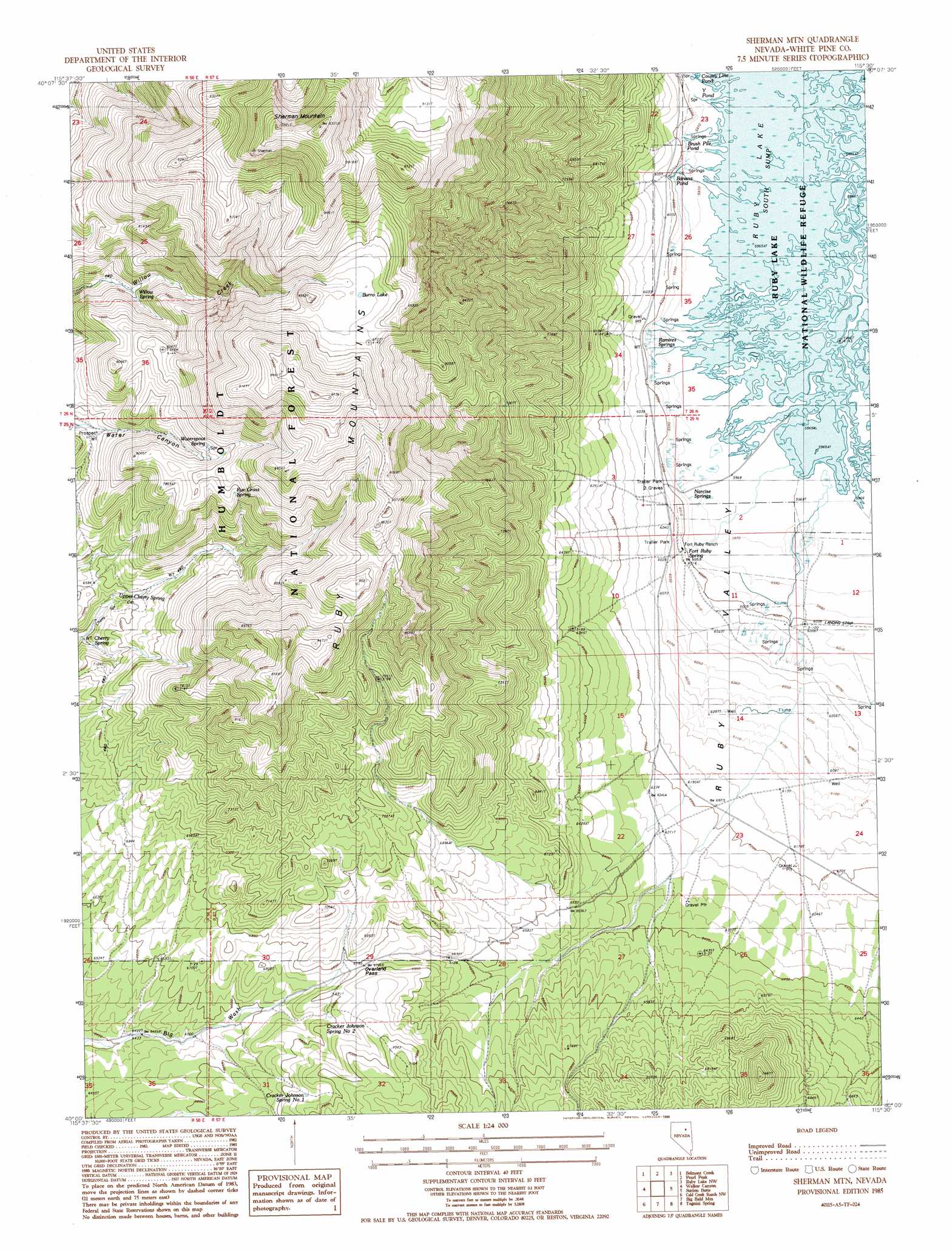
USGS Topo Quad 40115a5 - 1:24,000 scale
| Topo Map Name: | Sherman Mountain |
| USGS Topo Quad ID: | 40115a5 |
| Print Size: | ca. 21 1/4" wide x 27" high |
| Southeast Coordinates: | 40° N latitude / 115.5° W longitude |
| Map Center Coordinates: | 40.0625° N latitude / 115.5625° W longitude |
| U.S. State: | NV |
| Filename: | o40115a5.jpg |
| Download Map JPG Image: | Sherman Mountain topo map 1:24,000 scale |
| Map Type: | Topographic |
| Topo Series: | 7.5´ |
| Map Scale: | 1:24,000 |
| Source of Map Images: | United States Geological Survey (USGS) |
| Alternate Map Versions: |
Sherman Mtn NV 1985, updated 1986 Download PDF Buy paper map Sherman Mountain NV 2012 Download PDF Buy paper map Sherman Mountain NV 2014 Download PDF Buy paper map |
| FStopo: | US Forest Service topo Sherman Mountain is available: Download FStopo PDF Download FStopo TIF |
1:24,000 Topo Quads surrounding Sherman Mountain
East Of Bailey Mountain |
Frost Creek |
Harrison Pass |
Franklin Lake Sw |
Franklin Lake Se |
Sadler Basin |
Belmont Creek |
Pearl Peak |
Ruby Lake Nw |
Ruby Lake Ne |
Railroad Pass |
Walker Canyon |
Sherman Mountain |
Station Butte |
Ruby Lake Se |
Diamond Springs |
Cold Creek Ranch Nw |
Big Bald Mountain |
Tognini Spring |
Junction Well |
Christina Peak |
Cold Creek Ranch |
Mooney Basin Summit |
Long Valley Slough |
Cabin Spring |
> Back to 40115a1 at 1:100,000 scale
> Back to 40114a1 at 1:250,000 scale
> Back to U.S. Topo Maps home
Sherman Mountain topo map: Gazetteer
Sherman Mountain: Airports
Fort Ruby Ranch Airstrip elevation 1831m 6007′Sherman Mountain: Gaps
Overland Pass elevation 2072m 6797′Sherman Mountain: Lakes
Banana Pond elevation 1827m 5994′Brush Pile Pond elevation 1823m 5980′
Burro Lake elevation 2641m 8664′
County Line Pond elevation 1820m 5971′
Y Pond elevation 1819m 5967′
Sherman Mountain: Populated Places
Hobson (historical) elevation 1835m 6020′Sherman Mountain: Post Offices
Hobson Post Office (historical) elevation 1835m 6020′Sherman Mountain: Springs
Cherry Spring elevation 2090m 6856′Cracker Johnson Spring Number One elevation 2103m 6899′
Cracker Johnson Spring Number Two elevation 2057m 6748′
Fort Ruby Spring elevation 1830m 6003′
Narcise Springs elevation 1823m 5980′
Ramires Springs elevation 1828m 5997′
Rye Grass Spring elevation 2414m 7919′
Upper Cherry Spring elevation 2119m 6952′
Waterspout Spring elevation 2384m 7821′
Willow Spring elevation 2265m 7431′
Sherman Mountain: Summits
Sherman Mountain elevation 3114m 10216′Sherman Mountain digital topo map on disk
Buy this Sherman Mountain topo map showing relief, roads, GPS coordinates and other geographical features, as a high-resolution digital map file on DVD: