Railroad Pass Topo Map Nevada
To zoom in, hover over the map of Railroad Pass
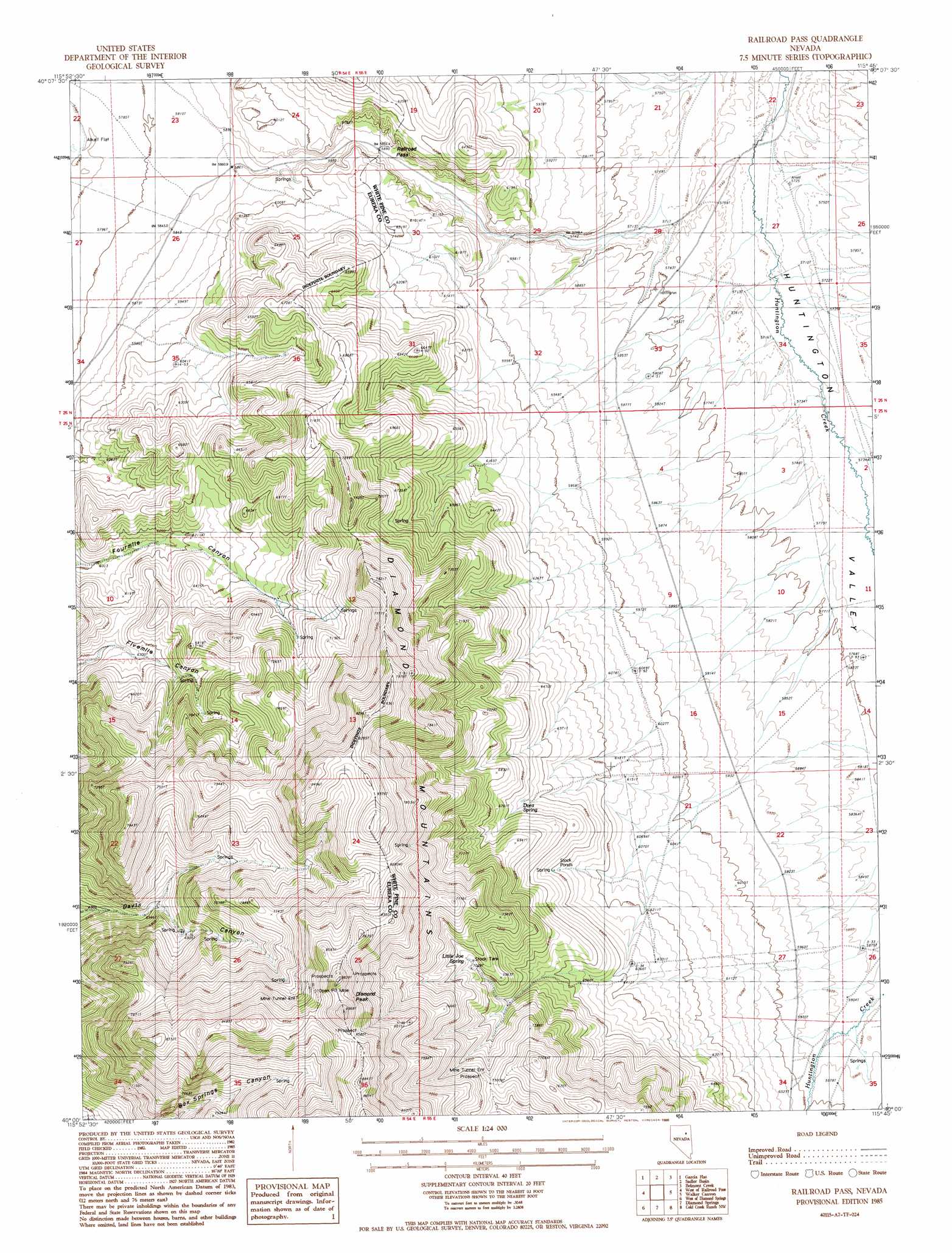
USGS Topo Quad 40115a7 - 1:24,000 scale
| Topo Map Name: | Railroad Pass |
| USGS Topo Quad ID: | 40115a7 |
| Print Size: | ca. 21 1/4" wide x 27" high |
| Southeast Coordinates: | 40° N latitude / 115.75° W longitude |
| Map Center Coordinates: | 40.0625° N latitude / 115.8125° W longitude |
| U.S. State: | NV |
| Filename: | o40115a7.jpg |
| Download Map JPG Image: | Railroad Pass topo map 1:24,000 scale |
| Map Type: | Topographic |
| Topo Series: | 7.5´ |
| Map Scale: | 1:24,000 |
| Source of Map Images: | United States Geological Survey (USGS) |
| Alternate Map Versions: |
Railroad Pass NV 1985, updated 1986 Download PDF Buy paper map Railroad Pass NV 2012 Download PDF Buy paper map Railroad Pass NV 2014 Download PDF Buy paper map |
1:24,000 Topo Quads surrounding Railroad Pass
Coffin Mountain |
Bailey Mountain |
East Of Bailey Mountain |
Frost Creek |
Harrison Pass |
Mineral Hill |
Garcia Flat |
Sadler Basin |
Belmont Creek |
Pearl Peak |
Telegraph Canyon |
West Of Railroad Pass |
Railroad Pass |
Walker Canyon |
Sherman Mountain |
Bailey Pass |
West Of Diamond Springs |
Diamond Springs |
Cold Creek Ranch Nw |
Big Bald Mountain |
Tule Dam Spring |
West Of Christina Peak |
Christina Peak |
Cold Creek Ranch |
Mooney Basin Summit |
> Back to 40115a1 at 1:100,000 scale
> Back to 40114a1 at 1:250,000 scale
> Back to U.S. Topo Maps home
Railroad Pass topo map: Gazetteer
Railroad Pass: Gaps
Railroad Pass elevation 1800m 5905′Railroad Pass: Mines
Concord Mine elevation 2434m 7985′Diamond Mine elevation 2604m 8543′
Garcia Mine elevation 2223m 7293′
Mulligan Mine elevation 2250m 7381′
Railroad Pass: Springs
Arthur Spring elevation 1796m 5892′Box Spring Creek Spring elevation 2329m 7641′
Della Spring elevation 1842m 6043′
Dora Spring elevation 2059m 6755′
Etchemendy Number Four elevation 2153m 7063′
Etchemendy Number One elevation 2049m 6722′
Etchemendy Number Three elevation 2153m 7063′
Etchemendy Number Two elevation 2049m 6722′
Jim Swayne Spring elevation 1898m 6227′
Little Joe Spring elevation 2145m 7037′
Nancy Spring elevation 1893m 6210′
Railroad Pass: Summits
Diamond Peak elevation 2702m 8864′Railroad Pass digital topo map on disk
Buy this Railroad Pass topo map showing relief, roads, GPS coordinates and other geographical features, as a high-resolution digital map file on DVD: