Green Mountain Topo Map Nevada
To zoom in, hover over the map of Green Mountain
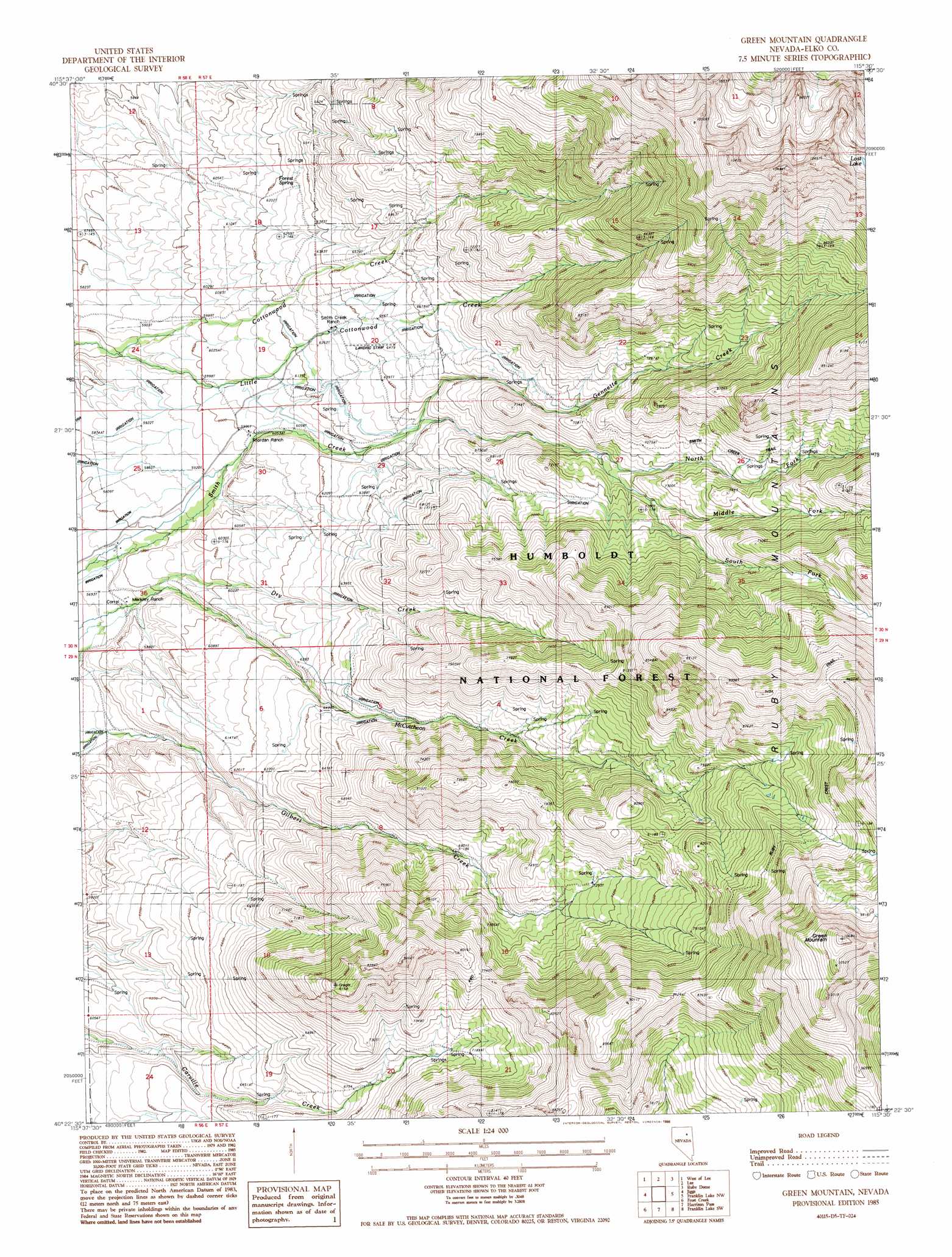
USGS Topo Quad 40115d5 - 1:24,000 scale
| Topo Map Name: | Green Mountain |
| USGS Topo Quad ID: | 40115d5 |
| Print Size: | ca. 21 1/4" wide x 27" high |
| Southeast Coordinates: | 40.375° N latitude / 115.5° W longitude |
| Map Center Coordinates: | 40.4375° N latitude / 115.5625° W longitude |
| U.S. State: | NV |
| Filename: | o40115d5.jpg |
| Download Map JPG Image: | Green Mountain topo map 1:24,000 scale |
| Map Type: | Topographic |
| Topo Series: | 7.5´ |
| Map Scale: | 1:24,000 |
| Source of Map Images: | United States Geological Survey (USGS) |
| Alternate Map Versions: |
Green Mountain NV 1985, updated 1986 Download PDF Buy paper map Green Mountain NV 2012 Download PDF Buy paper map Green Mountain NV 2014 Download PDF Buy paper map |
| FStopo: | US Forest Service topo Green Mountain is available: Download FStopo PDF Download FStopo TIF |
1:24,000 Topo Quads surrounding Green Mountain
White Flats |
Te-Moak Well |
Noon Rock |
Lamoille |
Verdi Peak |
Red Spring |
West Of Lee |
Lee |
Ruby Dome |
Ruby Valley School |
Cedar Ridge |
Jiggs |
Green Mountain |
Franklin Lake Nw |
Franklin Lake Ne |
East Of Bailey Mountain |
Frost Creek |
Harrison Pass |
Franklin Lake Sw |
Franklin Lake Se |
Sadler Basin |
Belmont Creek |
Pearl Peak |
Ruby Lake Nw |
Ruby Lake Ne |
> Back to 40115a1 at 1:100,000 scale
> Back to 40114a1 at 1:250,000 scale
> Back to U.S. Topo Maps home
Green Mountain topo map: Gazetteer
Green Mountain: Basins
Carville Basin elevation 2157m 7076′Green Mountain: Canals
O'Connells Ditch elevation 2074m 6804′Suttles Ditch elevation 2085m 6840′
Green Mountain: Forests
Humboldt National Forest elevation 3254m 10675′Green Mountain: Lakes
Lost Lake elevation 3013m 9885′Green Mountain: Populated Places
Dry Creek elevation 1753m 5751′Green Mountain: Post Offices
Dry Creek Post Office (historical) elevation 1753m 5751′Green Mountain: Springs
Forest Spring elevation 1927m 6322′Green Mountain: Streams
Dry Creek elevation 1768m 5800′Gennette Creek elevation 1928m 6325′
Little Cottonwood Creek elevation 1774m 5820′
Middle Fork Smith Creek elevation 2133m 6998′
North Fork Smith Creek elevation 2070m 6791′
South Fork Smith Creek elevation 2072m 6797′
Green Mountain: Summits
Green Mountain elevation 3254m 10675′Green Mountain: Trails
Smith Creek Trail elevation 2355m 7726′Green Mountain digital topo map on disk
Buy this Green Mountain topo map showing relief, roads, GPS coordinates and other geographical features, as a high-resolution digital map file on DVD: