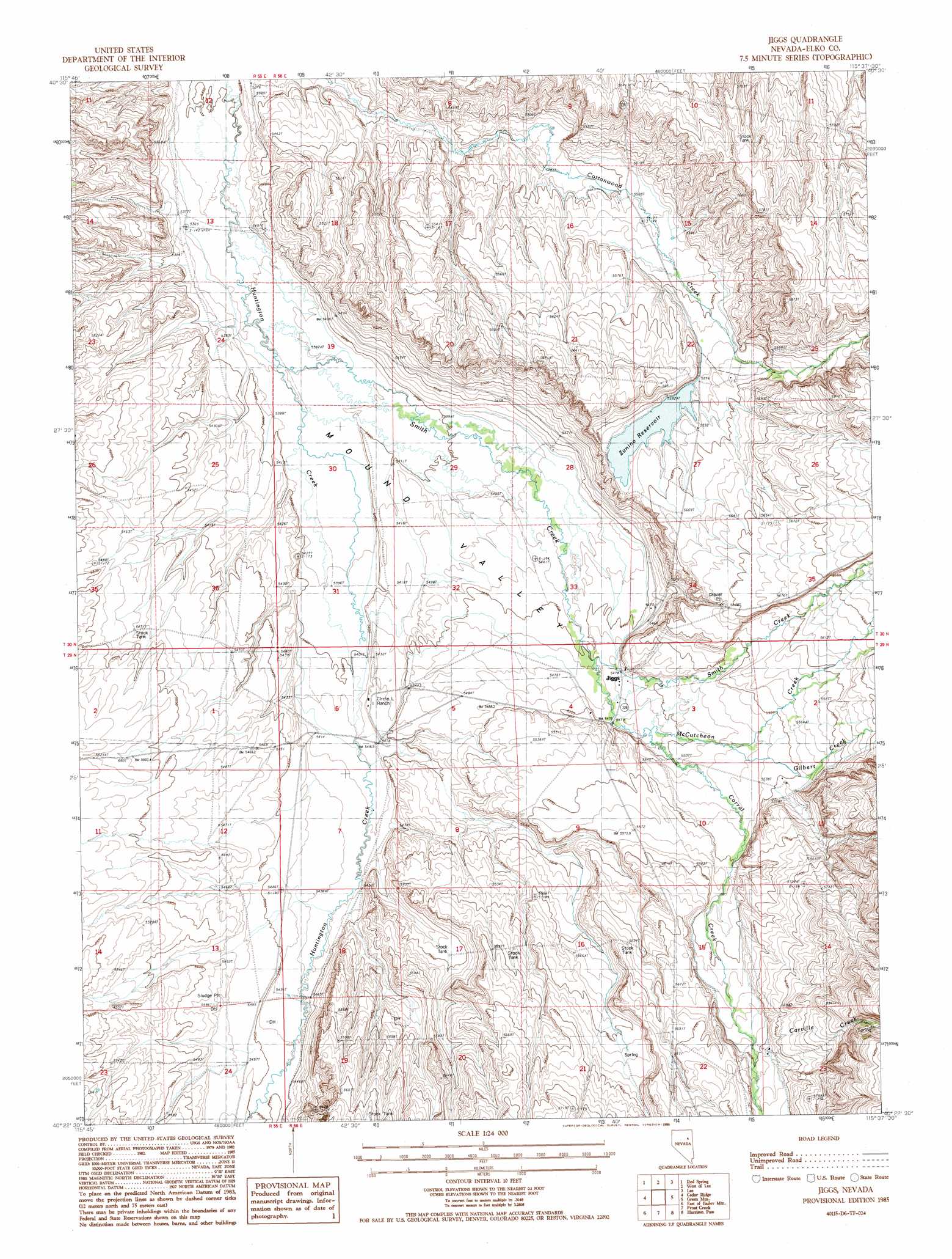
Jiggs Topo Map Nevada
To zoom in, hover over the map of Jiggs
USGS Topo Quad 40115d6 - 1:24,000 scale
| Topo Map Name: | Jiggs |
| USGS Topo Quad ID: | 40115d6 |
| Print Size: | ca. 21 1/4" wide x 27" high |
| Southeast Coordinates: | 40.375° N latitude / 115.625° W longitude |
| Map Center Coordinates: | 40.4375° N latitude / 115.6875° W longitude |
| U.S. State: | NV |
| Filename: | o40115d6.jpg |
| Download Map JPG Image: | Jiggs topo map 1:24,000 scale |
| Map Type: | Topographic |
| Topo Series: | 7.5´ |
| Map Scale: | 1:24,000 |
| Source of Map Images: | United States Geological Survey (USGS) |
| Alternate Map Versions: |
Jiggs NV 1985, updated 1986 Download PDF Buy paper map Jiggs NV 2012 Download PDF Buy paper map Jiggs NV 2015 Download PDF Buy paper map |
| FStopo: | US Forest Service topo Jiggs is available: Download FStopo PDF Download FStopo TIF |
1:24,000 Topo Quads surrounding Jiggs
Grindstone Mountain |
White Flats |
Te-Moak Well |
Noon Rock |
Lamoille |
Bullion |
Red Spring |
West Of Lee |
Lee |
Ruby Dome |
Robinson Mountain |
Cedar Ridge |
Jiggs |
Green Mountain |
Franklin Lake Nw |
Bailey Mountain |
East Of Bailey Mountain |
Frost Creek |
Harrison Pass |
Franklin Lake Sw |
Garcia Flat |
Sadler Basin |
Belmont Creek |
Pearl Peak |
Ruby Lake Nw |
> Back to 40115a1 at 1:100,000 scale
> Back to 40114a1 at 1:250,000 scale
> Back to U.S. Topo Maps home
Jiggs topo map: Gazetteer
Jiggs: Dams
Zunino Reservoir Dam elevation 1702m 5583′Jiggs: Mines
Mineral Soap Mine elevation 1639m 5377′Jiggs: Populated Places
Jiggs elevation 1672m 5485′Jiggs: Post Offices
Jiggs Post Office elevation 1672m 5485′Skelton Post Office (historical) elevation 1676m 5498′
Jiggs: Reservoirs
Zunino Reservoir elevation 1702m 5583′Jiggs: Streams
Carville Creek elevation 1721m 5646′Corral Creek elevation 1685m 5528′
Gilbert Creek elevation 1673m 5488′
McCutcheon Creek elevation 1684m 5524′
Smith Creek elevation 1635m 5364′
Jiggs: Valleys
Huntington Valley elevation 1651m 5416′Mound Valley elevation 1641m 5383′
Jiggs: Wells
Hansel Well Number 2 elevation 1663m 5456′Jiggs digital topo map on disk
Buy this Jiggs topo map showing relief, roads, GPS coordinates and other geographical features, as a high-resolution digital map file on DVD: