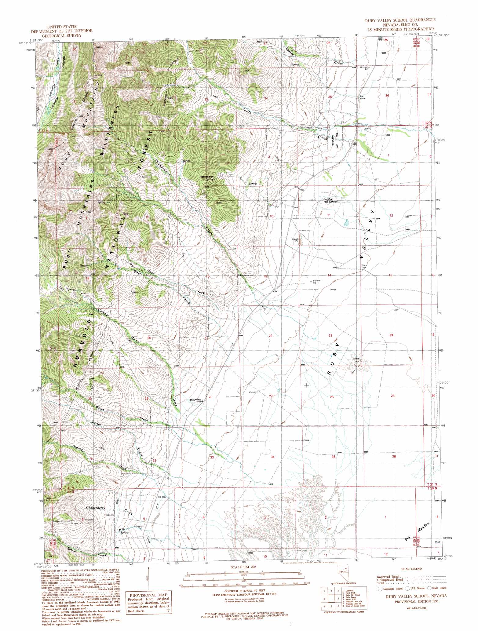
Ruby Valley School Topo Map Nevada
To zoom in, hover over the map of Ruby Valley School
USGS Topo Quad 40115e3 - 1:24,000 scale
| Topo Map Name: | Ruby Valley School |
| USGS Topo Quad ID: | 40115e3 |
| Print Size: | ca. 21 1/4" wide x 27" high |
| Southeast Coordinates: | 40.5° N latitude / 115.25° W longitude |
| Map Center Coordinates: | 40.5625° N latitude / 115.3125° W longitude |
| U.S. State: | NV |
| Filename: | o40115e3.jpg |
| Download Map JPG Image: | Ruby Valley School topo map 1:24,000 scale |
| Map Type: | Topographic |
| Topo Series: | 7.5´ |
| Map Scale: | 1:24,000 |
| Source of Map Images: | United States Geological Survey (USGS) |
| Alternate Map Versions: |
Ruby Valley School NV 1990, updated 1991 Download PDF Buy paper map Ruby Valley School NV 2012 Download PDF Buy paper map Ruby Valley School NV 2014 Download PDF Buy paper map |
| FStopo: | US Forest Service topo Ruby Valley School is available: Download FStopo PDF Download FStopo TIF |
1:24,000 Topo Quads surrounding Ruby Valley School
Boyd Reservoir |
Halleck Sw |
Soldier Peak |
Secret Valley |
Gordon Creek |
Noon Rock |
Lamoille |
Verdi Peak |
Ruby City Creek |
Arizona Spring |
Lee |
Ruby Dome |
Ruby Valley School |
Smith Well |
Valley Mountain |
Green Mountain |
Franklin Lake Nw |
Franklin Lake Ne |
West Of Delcer Buttes |
Delcer Buttes |
Harrison Pass |
Franklin Lake Sw |
Franklin Lake Se |
Medicine Spring |
Odgers Ranch |
> Back to 40115e1 at 1:100,000 scale
> Back to 40114a1 at 1:250,000 scale
> Back to U.S. Topo Maps home
Ruby Valley School topo map: Gazetteer
Ruby Valley School: Flats
Big Meadow elevation 1818m 5964′Ruby Valley School: Populated Places
Fair Play (historical) elevation 1849m 6066′Schley (historical) elevation 1855m 6085′
Ruby Valley School: Post Offices
Fair Play Post Office (historical) elevation 1849m 6066′Schley Post Office (historical) elevation 1855m 6085′
Ruby Valley School: Springs
Sulphur Hot Springs elevation 1844m 6049′Watermelon Spring elevation 2104m 6902′
Ruby Valley School: Streams
Baxter Creek elevation 1852m 6076′Birch Creek elevation 1843m 6046′
Carter Creek elevation 1823m 5980′
Chokecherry Creek elevation 1859m 6099′
Gedney Creek elevation 1833m 6013′
Lutts Creek elevation 1829m 6000′
Mose Creek elevation 1839m 6033′
Spring Creek elevation 1855m 6085′
Thompson Creek elevation 1857m 6092′
Wines Creek elevation 1841m 6040′
Ruby Valley School digital topo map on disk
Buy this Ruby Valley School topo map showing relief, roads, GPS coordinates and other geographical features, as a high-resolution digital map file on DVD: