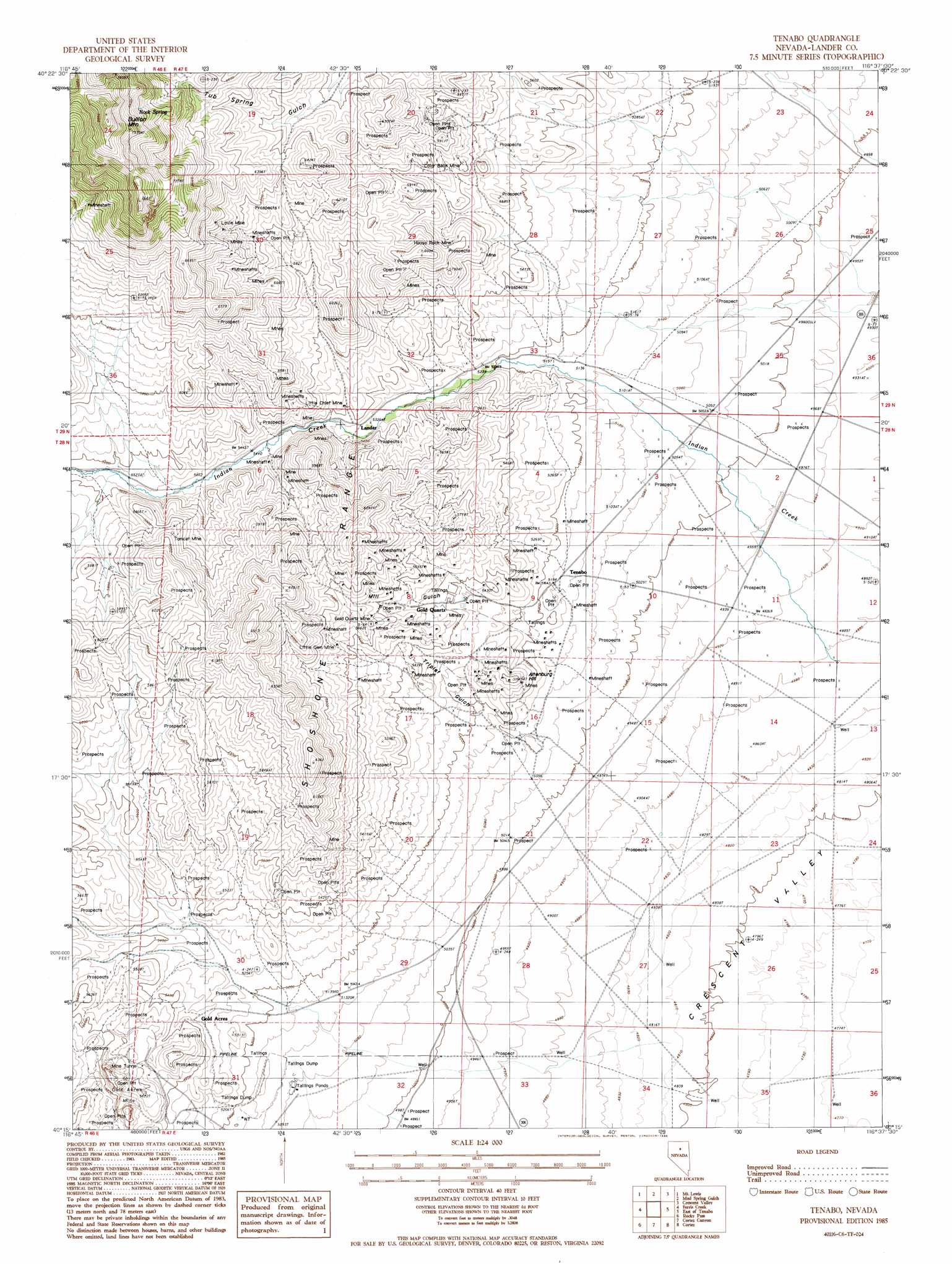
Tenabo Topo Map Nevada
To zoom in, hover over the map of Tenabo
USGS Topo Quad 40116c6 - 1:24,000 scale
| Topo Map Name: | Tenabo |
| USGS Topo Quad ID: | 40116c6 |
| Print Size: | ca. 21 1/4" wide x 27" high |
| Southeast Coordinates: | 40.25° N latitude / 116.625° W longitude |
| Map Center Coordinates: | 40.3125° N latitude / 116.6875° W longitude |
| U.S. State: | NV |
| Filename: | o40116c6.jpg |
| Download Map JPG Image: | Tenabo topo map 1:24,000 scale |
| Map Type: | Topographic |
| Topo Series: | 7.5´ |
| Map Scale: | 1:24,000 |
| Source of Map Images: | United States Geological Survey (USGS) |
| Alternate Map Versions: |
Tenabo NV 1985, updated 1986 Download PDF Buy paper map Tenabo NV 2012 Download PDF Buy paper map Tenabo NV 2014 Download PDF Buy paper map |
1:24,000 Topo Quads surrounding Tenabo
Blossom Spring |
Bateman Spring |
Mule Canyon |
The Geysers |
Beowawe |
Crippen Canyon |
Mount Lewis |
Mud Spring Gulch |
Crescent Valley |
Tumbleweed Flat |
Goat Peak |
Ferris Creek |
Tenabo |
East Of Tenabo |
Hand-Me-Down Creek |
Carico Lake North |
Rocky Pass |
Cortez Canyon |
Cortez |
Buckhorn Mine |
Carico Lake South |
Wood Spring Canyon |
Wenban Spring |
Dugout Spring |
Rocky Hills |
> Back to 40116a1 at 1:100,000 scale
> Back to 40116a1 at 1:250,000 scale
> Back to U.S. Topo Maps home
Tenabo topo map: Gazetteer
Tenabo: Mines
Ajax Mine elevation 1705m 5593′Altenburg Hill Mine elevation 1631m 5351′
Altenburg Mine elevation 1618m 5308′
Altenburg Placer Mine elevation 1562m 5124′
Badger Mine elevation 1775m 5823′
Blue Eagle Mine elevation 1673m 5488′
Blue Matrix Mine elevation 1953m 6407′
Blue Nugget Mine elevation 1612m 5288′
Blue Rock Mine elevation 1790m 5872′
Blue Sky Mine elevation 1623m 5324′
Bridal Vein Mine elevation 1790m 5872′
Bronco Number Two Placer Mine elevation 1790m 5872′
Caledonia Placer Mine elevation 1790m 5872′
Campbell and Young Mine elevation 1790m 5872′
Color Back Mine elevation 1730m 5675′
Desert Placers Mine elevation 1790m 5872′
Dutch Oven Mine elevation 1790m 5872′
Dutch Oven Placer Mine elevation 1790m 5872′
Emma Number Two Placer Mine elevation 1790m 5872′
Empire Mine elevation 1790m 5872′
Estella Bertrano Mine elevation 1790m 5872′
Euclid Mine elevation 1790m 5872′
Exile Mine elevation 1790m 5872′
Extra Mine elevation 1577m 5173′
Fairview Placer Mine elevation 1790m 5872′
Gem Mine elevation 1790m 5872′
Giffen Placer Mine elevation 1790m 5872′
Gold Acres Mine elevation 1660m 5446′
Gold Pan elevation 1790m 5872′
Gold Pan Mine elevation 1717m 5633′
Gold Pan Placer Mine elevation 1790m 5872′
Gold Quartz Mine elevation 1710m 5610′
Gold Slug Placer Mine elevation 1790m 5872′
Grand Prize Mine elevation 2037m 6683′
Gylding Mine elevation 1736m 5695′
Gylding Number Two Placer Mine elevation 1790m 5872′
Hale and May Mine elevation 1790m 5872′
House Rock Mine elevation 1759m 5770′
Independence Placer Mine elevation 1790m 5872′
Jarbidge Mine elevation 1790m 5872′
Lander Mine elevation 1790m 5872′
Little Chief Mine elevation 1653m 5423′
Little Gem Mine elevation 1733m 5685′
Little Phoenix Mine elevation 1790m 5872′
Locust Mine elevation 1790m 5872′
Locust Placer Mine elevation 1790m 5872′
Lovie Mine elevation 1969m 6459′
Lucky Boy Mine elevation 1790m 5872′
Lucky Boy Placer Mine elevation 1790m 5872′
Lyon Mine elevation 1790m 5872′
Marilyn Placer Mine elevation 1790m 5872′
Mary Ellen Place Mine elevation 1790m 5872′
Mill Gulch Placer Mine elevation 1695m 5561′
Mineral Range Mine elevation 1790m 5872′
Minnesota Placer Mine elevation 1790m 5872′
New Blue Mine elevation 1791m 5875′
No Name Number One Mine elevation 1725m 5659′
Norma Placer Mine elevation 1790m 5872′
Old Campground Mine elevation 1771m 5810′
Old Mill Mine elevation 1790m 5872′
Old Tenabo Placer Mine elevation 1790m 5872′
Pastime Mine elevation 1790m 5872′
Phoenix Mine elevation 1755m 5757′
Plastime Placer Mine elevation 1790m 5872′
Raleigh Mine elevation 1794m 5885′
Red Hills Mine elevation 1790m 5872′
Rex Number One Placer Mine elevation 1790m 5872′
Rex Number Two Placer Mine elevation 1790m 5872′
Rufan Mine elevation 1814m 5951′
Sander Mine elevation 1790m 5872′
Schultes Mine elevation 1790m 5872′
Silver Gem Mine elevation 1790m 5872′
Silver Grey Mine elevation 1790m 5872′
Silver Prize Mine elevation 1635m 5364′
Silver Sides Mine elevation 1713m 5620′
Stanley Mine elevation 1790m 5872′
Starting Point Placer Mine elevation 1790m 5872′
Steinich Mine elevation 1756m 5761′
Super-X Mine elevation 1661m 5449′
Tomcat Mine elevation 1820m 5971′
Triplett Group Mines elevation 1597m 5239′
Valley View Mine elevation 1790m 5872′
Viola Mine elevation 1790m 5872′
Virginia Placer Mine elevation 1790m 5872′
Wonder Placer Mine elevation 1790m 5872′
Yellow Streak Placer Mine elevation 1790m 5872′
Tenabo: Populated Places
Bullion (historical) elevation 1603m 5259′Frisbie (historical) elevation 1537m 5042′
Gold Acres elevation 1651m 5416′
Gold Quartz elevation 1695m 5561′
Lander (historical) elevation 1632m 5354′
Mill Gulch (historical) elevation 1595m 5232′
Tenabo elevation 1577m 5173′
Tenabo: Post Offices
Frisbie Post Office (historical) elevation 1537m 5042′Lander Post Office (historical) elevation 1632m 5354′
Tenabo Post Office (historical) elevation 1577m 5173′
Tenabo: Springs
Rock Spring elevation 2151m 7057′Tenabo: Summits
Altenburg Hill elevation 1642m 5387′Bullion Mountain elevation 2429m 7969′
Tenabo: Valleys
Mill Gulch elevation 1618m 5308′Triplet Gulch elevation 1561m 5121′
Tenabo digital topo map on disk
Buy this Tenabo topo map showing relief, roads, GPS coordinates and other geographical features, as a high-resolution digital map file on DVD: