Mount Lewis Topo Map Nevada
To zoom in, hover over the map of Mount Lewis
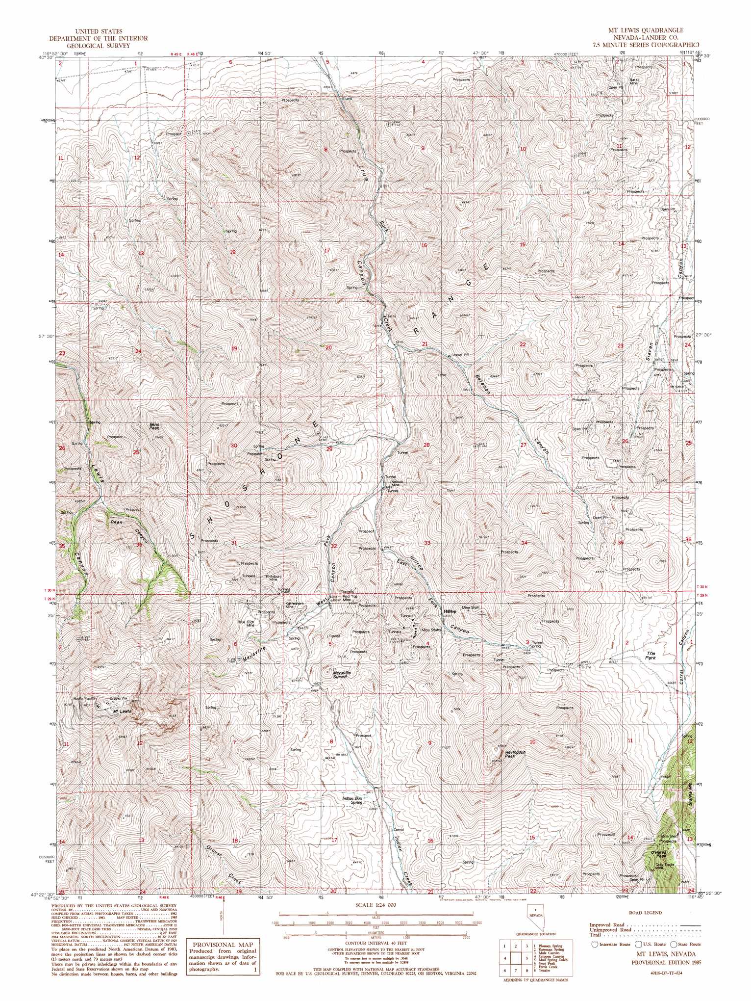
USGS Topo Quad 40116d7 - 1:24,000 scale
| Topo Map Name: | Mount Lewis |
| USGS Topo Quad ID: | 40116d7 |
| Print Size: | ca. 21 1/4" wide x 27" high |
| Southeast Coordinates: | 40.375° N latitude / 116.75° W longitude |
| Map Center Coordinates: | 40.4375° N latitude / 116.8125° W longitude |
| U.S. State: | NV |
| Filename: | o40116d7.jpg |
| Download Map JPG Image: | Mount Lewis topo map 1:24,000 scale |
| Map Type: | Topographic |
| Topo Series: | 7.5´ |
| Map Scale: | 1:24,000 |
| Source of Map Images: | United States Geological Survey (USGS) |
| Alternate Map Versions: |
Mt. Lewis NV 1985, updated 1986 Download PDF Buy paper map Mount Lewis NV 2012 Download PDF Buy paper map Mount Lewis NV 2014 Download PDF Buy paper map |
1:24,000 Topo Quads surrounding Mount Lewis
Snow Gulch |
Battle Mountain |
Stony Point |
Argenta |
Dunphy |
Galena |
Blossom Spring |
Bateman Spring |
Mule Canyon |
The Geysers |
Mccoy Ne |
Crippen Canyon |
Mount Lewis |
Mud Spring Gulch |
Crescent Valley |
Redrock Spring |
Goat Peak |
Ferris Creek |
Tenabo |
East Of Tenabo |
Moss Creek |
Carico Lake North |
Rocky Pass |
Cortez Canyon |
Cortez |
> Back to 40116a1 at 1:100,000 scale
> Back to 40116a1 at 1:250,000 scale
> Back to U.S. Topo Maps home
Mount Lewis topo map: Gazetteer
Mount Lewis: Flats
The Park elevation 2012m 6601′Mount Lewis: Gaps
Dixie Pass elevation 2340m 7677′Mount Lewis: Mines
Aztec Group Mine elevation 2029m 6656′Barse Mine elevation 1654m 5426′
Bateman Canyon Mine elevation 1993m 6538′
Battle Mountain Mine elevation 1834m 6017′
Blue Dick Mine elevation 2155m 7070′
Celestine O'Neal Mine elevation 1834m 6017′
Dean Mine elevation 2307m 7568′
Defiance Mine elevation 1834m 6017′
Dusang and Logan Mine elevation 2002m 6568′
Eagle Mines elevation 2346m 7696′
Eagle Monitor Mine elevation 1834m 6017′
First Riffles Mine elevation 1735m 5692′
Gold Dyke Mine elevation 2088m 6850′
Gold Rod Mine elevation 2328m 7637′
Gray Eagle Mine elevation 2327m 7634′
Highland Chief Mine elevation 2285m 7496′
Hilltop Mine elevation 2072m 6797′
Jenkins Mine elevation 2328m 7637′
Kattenhorn Mine elevation 2088m 6850′
Kimberly Consolidated Mine elevation 2112m 6929′
Miners Dream Mine elevation 1864m 6115′
Miners Dream Placer Mine elevation 1854m 6082′
Morning Glory Mine elevation 2328m 7637′
Neff Mine elevation 2328m 7637′
Nelson Mine elevation 1789m 5869′
O K Mine elevation 2328m 7637′
O'Neal Mine elevation 1834m 6017′
Paymaster and Christopher Mine elevation 2025m 6643′
Pittsburg Mine elevation 2220m 7283′
Red Top Mine elevation 1994m 6541′
Riffles Placer Mine elevation 1744m 5721′
Southern Pacific Lease Mine elevation 1929m 6328′
Starr Grove Mine elevation 1880m 6167′
Mount Lewis: Populated Places
Dean (historical) elevation 2164m 7099′Hilltop elevation 1969m 6459′
Maysville (historical) elevation 2076m 6811′
Middletown (historical) elevation 1886m 6187′
Pittsburgh (historical) elevation 1869m 6131′
Starr (historical) elevation 1880m 6167′
Mount Lewis: Post Offices
Dean Post Office elevation 2164m 7099′Hilltop Post Office (historical) elevation 1969m 6459′
Pittsburg Post Office elevation 1869m 6131′
Starr Post Office (historical) elevation 1880m 6167′
Mount Lewis: Springs
Bens Spring elevation 1824m 5984′Buck Spring elevation 2372m 7782′
Cherry Spring elevation 1823m 5980′
Indian Box Spring elevation 1965m 6446′
Tunnel Spring elevation 2080m 6824′
Mount Lewis: Streams
East Fork Rock Creek elevation 1798m 5898′West Fork Rock Creek elevation 1798m 5898′
Mount Lewis: Summits
Bens Peak elevation 2385m 7824′Granite Mountain elevation 2416m 7926′
Havingdon Peak elevation 2497m 8192′
Maysville Summit elevation 2166m 7106′
Mount Lewis elevation 2918m 9573′
O'Haras Peak elevation 2329m 7641′
Mount Lewis: Valleys
Bateman Canyon elevation 1696m 5564′Crum Canyon elevation 1539m 5049′
Dean Canyon elevation 2000m 6561′
Hilltop Canyon elevation 1798m 5898′
Maysville Canyon elevation 1792m 5879′
Mount Lewis digital topo map on disk
Buy this Mount Lewis topo map showing relief, roads, GPS coordinates and other geographical features, as a high-resolution digital map file on DVD: