Dunphy Topo Map Nevada
To zoom in, hover over the map of Dunphy
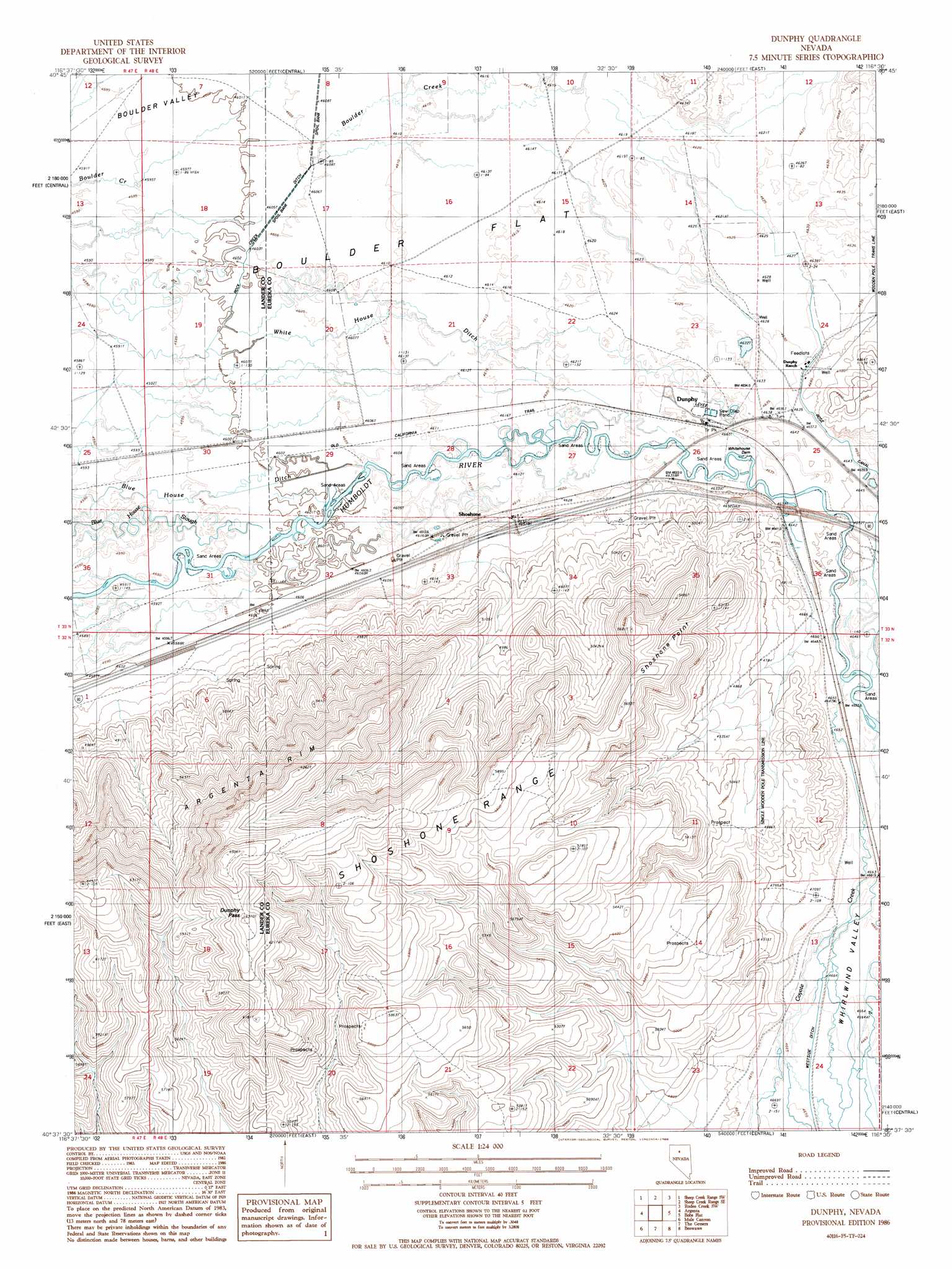
USGS Topo Quad 40116f5 - 1:24,000 scale
| Topo Map Name: | Dunphy |
| USGS Topo Quad ID: | 40116f5 |
| Print Size: | ca. 21 1/4" wide x 27" high |
| Southeast Coordinates: | 40.625° N latitude / 116.5° W longitude |
| Map Center Coordinates: | 40.6875° N latitude / 116.5625° W longitude |
| U.S. State: | NV |
| Filename: | o40116f5.jpg |
| Download Map JPG Image: | Dunphy topo map 1:24,000 scale |
| Map Type: | Topographic |
| Topo Series: | 7.5´ |
| Map Scale: | 1:24,000 |
| Source of Map Images: | United States Geological Survey (USGS) |
| Alternate Map Versions: |
Dunphy NV 1986, updated 1986 Download PDF Buy paper map Dunphy NV 2012 Download PDF Buy paper map Dunphy NV 2014 Download PDF Buy paper map |
1:24,000 Topo Quads surrounding Dunphy
Izzenhood Gap |
Sheep Creek Range Nw |
Sheep Creek Range Ne |
Rodeo Creek Nw |
Rodeo Creek Ne |
Izzenhood Spring |
Sheep Creek Range Sw |
Sheep Creek Range Se |
Rodeo Creek Sw |
Welches Canyon |
Stony Point |
Argenta |
Dunphy |
Bobs Flat |
Emigrant Pass |
Bateman Spring |
Mule Canyon |
The Geysers |
Beowawe |
Scotts Gulch |
Mount Lewis |
Mud Spring Gulch |
Crescent Valley |
Tumbleweed Flat |
Frenchie Flat |
> Back to 40116e1 at 1:100,000 scale
> Back to 40116a1 at 1:250,000 scale
> Back to U.S. Topo Maps home
Dunphy topo map: Gazetteer
Dunphy: Airports
Dunphy Ranch Landing Strip elevation 1414m 4639′Dunphy: Canals
Rock Creek Ditch elevation 1404m 4606′Rose Canal elevation 1417m 4648′
Dunphy: Cliffs
Argenta Rim elevation 1941m 6368′Dunphy: Dams
Blue House Dam elevation 1405m 4609′Rose Dam elevation 1419m 4655′
Whitehouse Dam elevation 1413m 4635′
Dunphy: Flats
Boulder Flat elevation 1407m 4616′Dunphy: Gaps
Dunphy Pass elevation 1785m 5856′Dunphy: Populated Places
Dunphy elevation 1414m 4639′Rixies elevation 1416m 4645′
Shoshone elevation 1413m 4635′
Dunphy: Post Offices
Dunphy Post Office (historical) elevation 1414m 4639′Dunphy: Streams
Coyote Creek elevation 1417m 4648′Dunphy: Summits
Shoshone Point elevation 1710m 5610′Dunphy: Trails
Old California Trail elevation 1406m 4612′Route of California Trail elevation 1405m 4609′
Dunphy digital topo map on disk
Buy this Dunphy topo map showing relief, roads, GPS coordinates and other geographical features, as a high-resolution digital map file on DVD: