Goldbanks Hills Topo Map Nevada
To zoom in, hover over the map of Goldbanks Hills
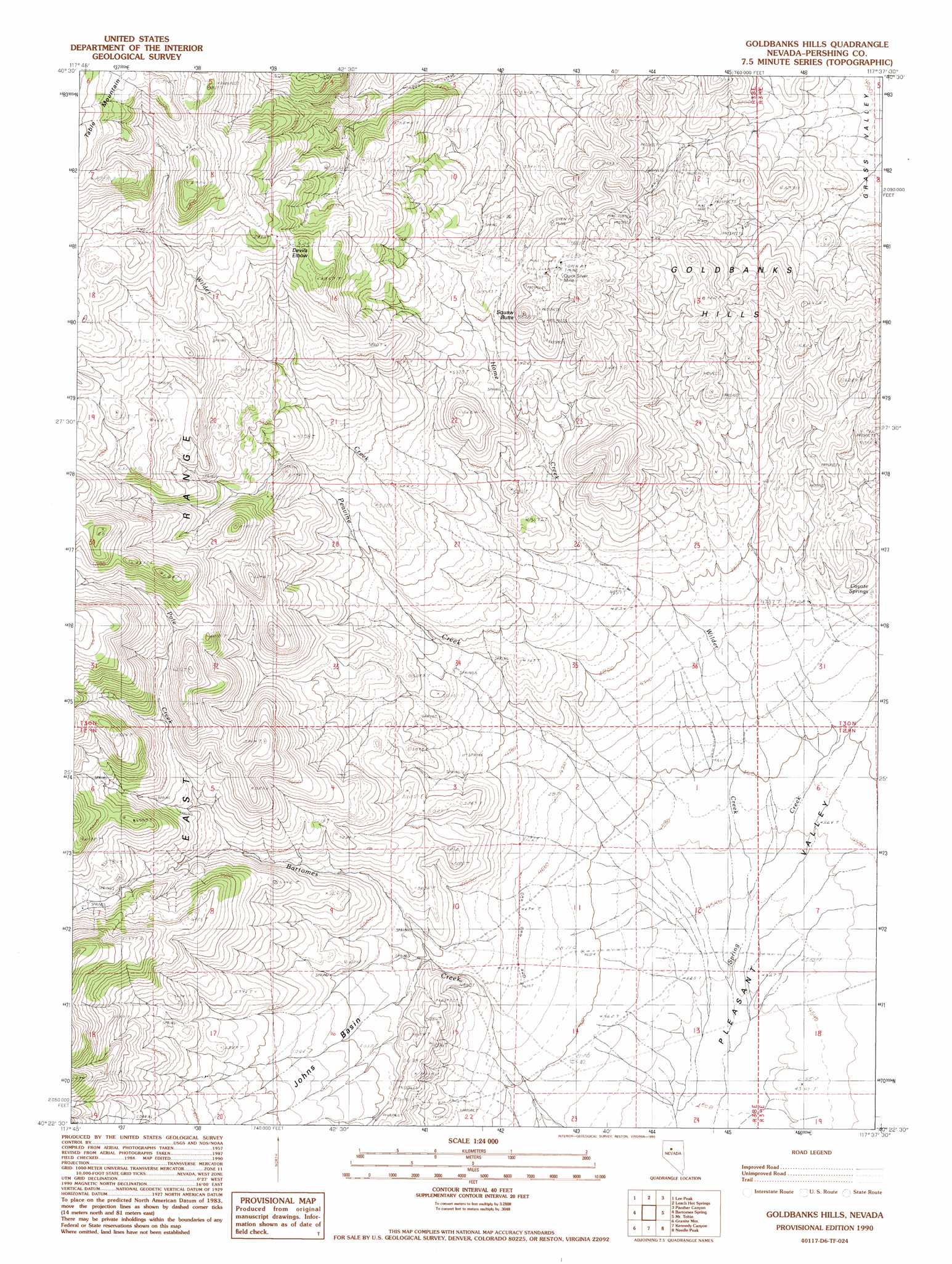
USGS Topo Quad 40117d6 - 1:24,000 scale
| Topo Map Name: | Goldbanks Hills |
| USGS Topo Quad ID: | 40117d6 |
| Print Size: | ca. 21 1/4" wide x 27" high |
| Southeast Coordinates: | 40.375° N latitude / 117.625° W longitude |
| Map Center Coordinates: | 40.4375° N latitude / 117.6875° W longitude |
| U.S. State: | NV |
| Filename: | o40117d6.jpg |
| Download Map JPG Image: | Goldbanks Hills topo map 1:24,000 scale |
| Map Type: | Topographic |
| Topo Series: | 7.5´ |
| Map Scale: | 1:24,000 |
| Source of Map Images: | United States Geological Survey (USGS) |
| Alternate Map Versions: |
Goldbanks Hills NV 1990, updated 1990 Download PDF Buy paper map Goldbanks Hills NV 2011 Download PDF Buy paper map Goldbanks Hills NV 2014 Download PDF Buy paper map |
1:24,000 Topo Quads surrounding Goldbanks Hills
Dun Glen |
Natchez Pass |
Clear Creek Ranch |
Sheep Ranch Canyon |
Smelser Pass |
Inskip Canyon |
Lee Peak |
Leach Hot Springs |
Panther Canyon |
China Mountain |
Kyle Hot Springs |
Bartomes Spring |
Goldbanks Hills |
Mount Tobin |
Buffalo Springs |
Kyle Hot Springs Sw |
Granite Mountain |
Kennedy Canyon |
Needle Peak |
Jersey Summit |
West Of Mckinney Pass |
Mckinney Pass |
Sou Hills |
Home Station Ranch |
Mount Moses |
> Back to 40117a1 at 1:100,000 scale
> Back to 40116a1 at 1:250,000 scale
> Back to U.S. Topo Maps home
Goldbanks Hills topo map: Gazetteer
Goldbanks Hills: Basins
Johns Basin elevation 1562m 5124′Goldbanks Hills: Flats
Devils Elbow elevation 1913m 6276′Goldbanks Hills: Mines
Goldbanks Quicksilver Mine elevation 1718m 5636′Old Timer Mine elevation 1440m 4724′
Quick Silver Mine elevation 1704m 5590′
Goldbanks Hills: Ranges
Goldbanks Hills elevation 1617m 5305′Goldbanks Hills: Springs
Coyote Springs elevation 1434m 4704′Goldbanks Hills: Streams
Bartomes Creek elevation 1592m 5223′Home Creek elevation 1488m 4881′
Peavine Creek elevation 1418m 4652′
Wilder Creek elevation 1389m 4557′
Goldbanks Hills: Summits
Squaw Butte elevation 1748m 5734′Goldbanks Hills: Valleys
Sweeney Canyon elevation 1459m 4786′Goldbanks Hills digital topo map on disk
Buy this Goldbanks Hills topo map showing relief, roads, GPS coordinates and other geographical features, as a high-resolution digital map file on DVD: