Buffalo Creek Topo Map Nevada
To zoom in, hover over the map of Buffalo Creek
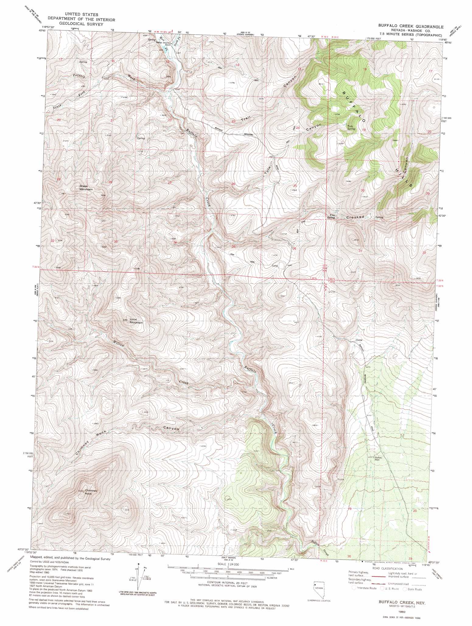
USGS Topo Quad 40119f7 - 1:24,000 scale
| Topo Map Name: | Buffalo Creek |
| USGS Topo Quad ID: | 40119f7 |
| Print Size: | ca. 21 1/4" wide x 27" high |
| Southeast Coordinates: | 40.625° N latitude / 119.75° W longitude |
| Map Center Coordinates: | 40.6875° N latitude / 119.8125° W longitude |
| U.S. State: | NV |
| Filename: | o40119f7.jpg |
| Download Map JPG Image: | Buffalo Creek topo map 1:24,000 scale |
| Map Type: | Topographic |
| Topo Series: | 7.5´ |
| Map Scale: | 1:24,000 |
| Source of Map Images: | United States Geological Survey (USGS) |
| Alternate Map Versions: |
Buffalo Creek NV 1980, updated 1980 Download PDF Buy paper map Buffalo Creek NV 2011 Download PDF Buy paper map Buffalo Creek NV 2014 Download PDF Buy paper map |
1:24,000 Topo Quads surrounding Buffalo Creek
Buckhorn Lake |
Burnt Lake |
Rye Patch Canyon |
Hillside Spring |
Crutcher Canyon |
Buckhorn Canyon |
Hole In The Ground |
Eddies Garden |
Poodle Mountain |
Squaw Valley |
Al Shinn Canyon |
Mixie Flat |
Buffalo Creek |
Horse Canyon |
Wall Spring |
Cherry Mountain |
Smoke Creek Ranch |
Salt Marsh |
Hog Spring |
Smith Canyon |
Bull Flat |
Red Rock Canyon |
Sheepshead Spring |
Reynard |
Pah-Rum Peak |
> Back to 40119e1 at 1:100,000 scale
> Back to 40118a1 at 1:250,000 scale
> Back to U.S. Topo Maps home
Buffalo Creek topo map: Gazetteer
Buffalo Creek: Flats
Buffalo Meadows elevation 1341m 4399′Buffalo Creek: Springs
Cow Spring elevation 1484m 4868′Crooked Canyon Spring elevation 1608m 5275′
Rimrock Spring elevation 1520m 4986′
Rosebush Spring elevation 1533m 5029′
Trail Canyon Spring elevation 1646m 5400′
Tule Spring elevation 1635m 5364′
Buffalo Creek: Streams
Chimney Rock Creek elevation 1244m 4081′North Fork Buffalo Creek elevation 1328m 4356′
Parsnip Wash elevation 1318m 4324′
South Fork Parsnip Wash elevation 1378m 4520′
West Fork Buffalo Creek elevation 1328m 4356′
Willow Creek elevation 1251m 4104′
Buffalo Creek: Summits
Chimney Rock elevation 1791m 5875′Grass Mountain elevation 1777m 5830′
Lone Mountain elevation 1642m 5387′
Buffalo Creek: Valleys
Buffalo Canyon elevation 1212m 3976′Chimney Rock Canyon elevation 1244m 4081′
Crooked Canyon elevation 1300m 4265′
Trail Canyon elevation 1343m 4406′
Tule Canyon elevation 1303m 4274′
Buffalo Creek: Wells
Buffalo Well elevation 1238m 4061′Buffalo Creek digital topo map on disk
Buy this Buffalo Creek topo map showing relief, roads, GPS coordinates and other geographical features, as a high-resolution digital map file on DVD: