Eddies Garden Topo Map Nevada
To zoom in, hover over the map of Eddies Garden
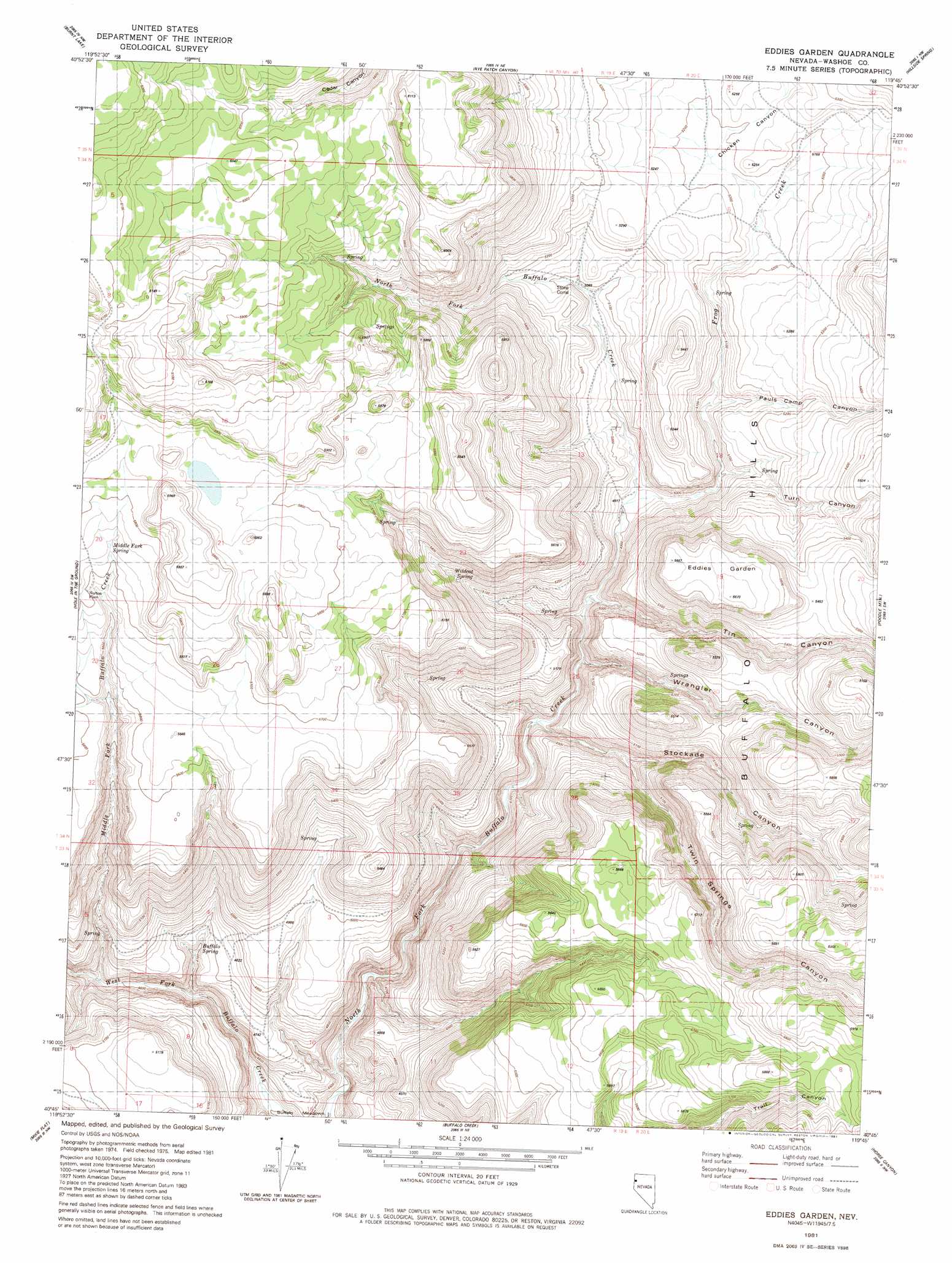
USGS Topo Quad 40119g7 - 1:24,000 scale
| Topo Map Name: | Eddies Garden |
| USGS Topo Quad ID: | 40119g7 |
| Print Size: | ca. 21 1/4" wide x 27" high |
| Southeast Coordinates: | 40.75° N latitude / 119.75° W longitude |
| Map Center Coordinates: | 40.8125° N latitude / 119.8125° W longitude |
| U.S. State: | NV |
| Filename: | o40119g7.jpg |
| Download Map JPG Image: | Eddies Garden topo map 1:24,000 scale |
| Map Type: | Topographic |
| Topo Series: | 7.5´ |
| Map Scale: | 1:24,000 |
| Source of Map Images: | United States Geological Survey (USGS) |
| Alternate Map Versions: |
Eddies Garden NV 1981, updated 1981 Download PDF Buy paper map Eddies Garden NV 2011 Download PDF Buy paper map Eddies Garden NV 2014 Download PDF Buy paper map |
1:24,000 Topo Quads surrounding Eddies Garden
Little Hat Mountain |
Duck Lake |
Juniper Springs |
Lost Creek Pass |
Fox Mountain |
Buckhorn Lake |
Burnt Lake |
Rye Patch Canyon |
Hillside Spring |
Crutcher Canyon |
Buckhorn Canyon |
Hole In The Ground |
Eddies Garden |
Poodle Mountain |
Squaw Valley |
Al Shinn Canyon |
Mixie Flat |
Buffalo Creek |
Horse Canyon |
Wall Spring |
Cherry Mountain |
Smoke Creek Ranch |
Salt Marsh |
Hog Spring |
Smith Canyon |
> Back to 40119e1 at 1:100,000 scale
> Back to 40118a1 at 1:250,000 scale
> Back to U.S. Topo Maps home
Eddies Garden topo map: Gazetteer
Eddies Garden: Springs
Buffalo Spring elevation 1438m 4717′Cottonwood Spring elevation 1593m 5226′
Middle Fork Spring elevation 1749m 5738′
Stone Corral Spring elevation 1709m 5606′
Wildcat Spring elevation 1611m 5285′
Eddies Garden: Streams
Frog Creek elevation 1496m 4908′Middle Fork Buffalo Creek elevation 1407m 4616′
Eddies Garden: Summits
Eddies Garden elevation 1727m 5666′Eddies Garden: Valleys
Chicken Canyon elevation 1573m 5160′Pauls Camp Canyon elevation 1537m 5042′
Stockade Canyon elevation 1452m 4763′
Tin Canyon elevation 1503m 4931′
Turn Canyon elevation 1523m 4996′
Twin Springs Canyon elevation 1475m 4839′
Wrangler Canyon elevation 1457m 4780′
Eddies Garden digital topo map on disk
Buy this Eddies Garden topo map showing relief, roads, GPS coordinates and other geographical features, as a high-resolution digital map file on DVD: