Crescent Mills Topo Map California
To zoom in, hover over the map of Crescent Mills
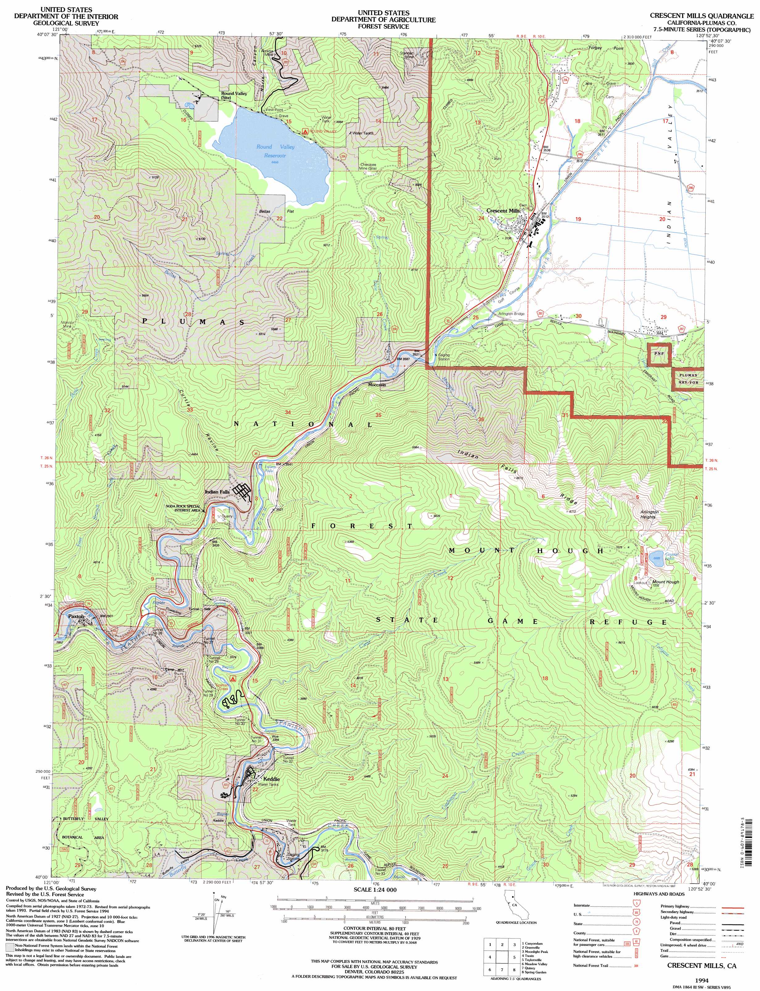
USGS Topo Quad 40120a8 - 1:24,000 scale
| Topo Map Name: | Crescent Mills |
| USGS Topo Quad ID: | 40120a8 |
| Print Size: | ca. 21 1/4" wide x 27" high |
| Southeast Coordinates: | 40° N latitude / 120.875° W longitude |
| Map Center Coordinates: | 40.0625° N latitude / 120.9375° W longitude |
| U.S. State: | CA |
| Filename: | o40120a8.jpg |
| Download Map JPG Image: | Crescent Mills topo map 1:24,000 scale |
| Map Type: | Topographic |
| Topo Series: | 7.5´ |
| Map Scale: | 1:24,000 |
| Source of Map Images: | United States Geological Survey (USGS) |
| Alternate Map Versions: |
Crescent Mills CA 1980, updated 1980 Download PDF Buy paper map Crescent Mills CA 1980, updated 1980 Download PDF Buy paper map Crescent Mills CA 1980, updated 1986 Download PDF Buy paper map Crescent Mills CA 1994, updated 1997 Download PDF Buy paper map Crescent Mills CA 2012 Download PDF Buy paper map Crescent Mills CA 2015 Download PDF Buy paper map |
| FStopo: | US Forest Service topo Crescent Mills is available: Download FStopo PDF Download FStopo TIF |
1:24,000 Topo Quads surrounding Crescent Mills
Chester |
Westwood West |
Westwood East |
Fredonyer Pass |
Diamond Mountain |
Almanor |
Canyondam |
Greenville |
Moonlight Peak |
Kettle Rock |
Caribou |
Twain |
Crescent Mills |
Taylorsville |
Genesee Valley |
Bucks Lake |
Meadow Valley |
Quincy |
Spring Garden |
Mount Ingalls |
Haskins Valley |
Dogwood Peak |
Onion Valley |
Blue Nose Mountain |
Johnsville |
> Back to 40120a1 at 1:100,000 scale
> Back to 40120a1 at 1:250,000 scale
> Back to U.S. Topo Maps home
Crescent Mills topo map: Gazetteer
Crescent Mills: Areas
Butterfly Valley Botanical Area elevation 1152m 3779′Crescent Mills: Bridges
Arlington Bridge elevation 1068m 3503′Crescent Mills: Capes
Forgay Point elevation 1149m 3769′Crescent Mills: Dams
Bidwell Lake 273 Dam elevation 1362m 4468′Crescent Mills: Falls
Indian Falls elevation 976m 3202′Crescent Mills: Flats
Bellas Flat elevation 1366m 4481′Crescent Mills: Lakes
Crystal Lake elevation 2040m 6692′Crescent Mills: Mines
Arcadia Mine elevation 1256m 4120′Cherokee Mine elevation 1394m 4573′
Monitor Mine elevation 1545m 5068′
Standart Mine elevation 1309m 4294′
Crescent Mills: Parks
Mount Hough State Game Refuge elevation 1560m 5118′Crescent Mills: Populated Places
Crescent Mills elevation 1075m 3526′Indian Falls elevation 993m 3257′
Keddie elevation 995m 3264′
Moccasin elevation 1072m 3517′
Paxton elevation 905m 2969′
Round Valley (historical) elevation 1378m 4520′
Crescent Mills: Post Offices
Crescent Mills Post Office elevation 1073m 3520′Crescent Mills: Reservoirs
Round Valley Reservoir elevation 1359m 4458′Round Valley Reservoir elevation 1362m 4468′
Crescent Mills: Ridges
Indian Falls Ridge elevation 1939m 6361′Crescent Mills: Streams
Bellas Creek elevation 1369m 4491′Big Blackhawk Creek elevation 955m 3133′
Butterfly Creek elevation 965m 3166′
Cashman Creek elevation 975m 3198′
Clear Creek elevation 930m 3051′
Dixie Creek elevation 1072m 3517′
Hough Creek elevation 1068m 3503′
Indian Creek elevation 904m 2965′
Moccasin Creek elevation 1062m 3484′
Soda Creek elevation 871m 2857′
Spanish Creek elevation 884m 2900′
Wolf Creek elevation 1068m 3503′
Crescent Mills: Summits
Arlington Heights elevation 2089m 6853′Hunodim Peak elevation 1621m 5318′
Mount Hough elevation 2201m 7221′
Crescent Mills: Tunnels
Tunnel Number 26 elevation 980m 3215′Tunnel Number 27 elevation 1021m 3349′
Tunnel Number 28 elevation 996m 3267′
Tunnel Number 29 elevation 984m 3228′
Tunnel Number 30 elevation 1039m 3408′
Tunnel Number 31 elevation 1021m 3349′
Tunnel Number 32 elevation 1048m 3438′
Tunnel Number 33 elevation 1124m 3687′
Crescent Mills: Valleys
Butterfly Valley elevation 966m 3169′Curtis Ravine elevation 968m 3175′
Indian Valley elevation 1092m 3582′
Crescent Mills digital topo map on disk
Buy this Crescent Mills topo map showing relief, roads, GPS coordinates and other geographical features, as a high-resolution digital map file on DVD: