Antelope Lake Topo Map California
To zoom in, hover over the map of Antelope Lake
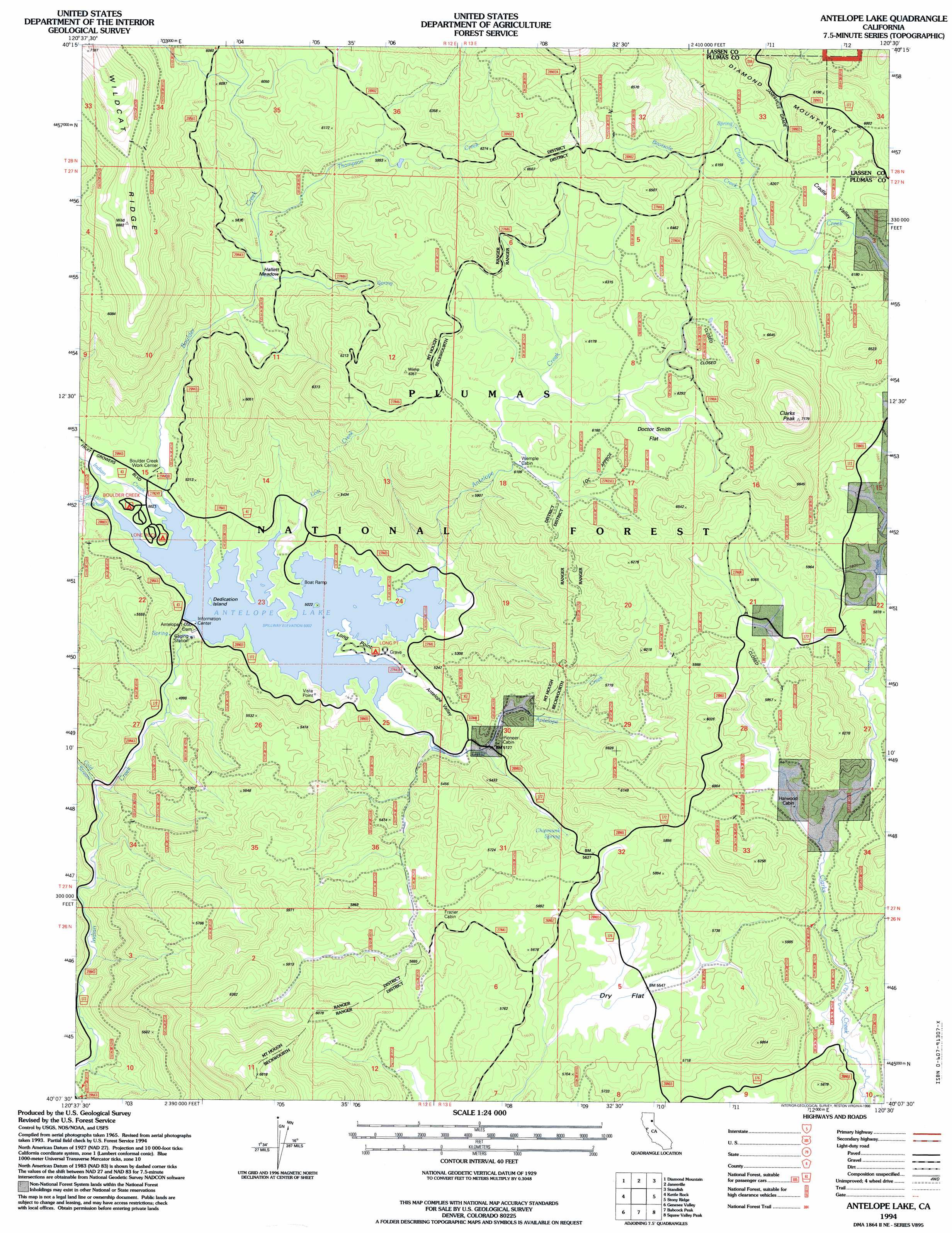
USGS Topo Quad 40120b5 - 1:24,000 scale
| Topo Map Name: | Antelope Lake |
| USGS Topo Quad ID: | 40120b5 |
| Print Size: | ca. 21 1/4" wide x 27" high |
| Southeast Coordinates: | 40.125° N latitude / 120.5° W longitude |
| Map Center Coordinates: | 40.1875° N latitude / 120.5625° W longitude |
| U.S. State: | CA |
| Filename: | o40120b5.jpg |
| Download Map JPG Image: | Antelope Lake topo map 1:24,000 scale |
| Map Type: | Topographic |
| Topo Series: | 7.5´ |
| Map Scale: | 1:24,000 |
| Source of Map Images: | United States Geological Survey (USGS) |
| Alternate Map Versions: |
Antelope Lake CA 1972, updated 1974 Download PDF Buy paper map Antelope Lake CA 1972, updated 1974 Download PDF Buy paper map Antelope Lake CA 1994, updated 1998 Download PDF Buy paper map Antelope Lake CA 1994, updated 1998 Download PDF Buy paper map Antelope Lake CA 2012 Download PDF Buy paper map Antelope Lake CA 2015 Download PDF Buy paper map |
| FStopo: | US Forest Service topo Antelope Lake is available: Download FStopo PDF Download FStopo TIF |
1:24,000 Topo Quads surrounding Antelope Lake
Roop Mountain |
Susanville |
Johnstonville |
Litchfield |
Shaffer Mountain |
Fredonyer Pass |
Diamond Mountain |
Janesville |
Standish |
Wendel Hot Springs |
Moonlight Peak |
Kettle Rock |
Antelope Lake |
Stony Ridge |
Milford |
Taylorsville |
Genesee Valley |
Babcock Peak |
Squaw Valley Peak |
Ferris Creek |
Spring Garden |
Mount Ingalls |
Grizzly Valley |
Crocker Mountain |
Dixie Mountain |
> Back to 40120a1 at 1:100,000 scale
> Back to 40120a1 at 1:250,000 scale
> Back to U.S. Topo Maps home
Antelope Lake topo map: Gazetteer
Antelope Lake: Basins
Cradle Valley elevation 1812m 5944′Antelope Lake: Capes
Long Point elevation 1534m 5032′Antelope Lake: Dams
Antelope 1-050 Dam elevation 1510m 4954′Antelope Valley Dam elevation 1526m 5006′
Antelope Lake: Flats
Doctor Smith Flat elevation 1878m 6161′Dry Flat elevation 1691m 5547′
Hallett Meadow elevation 1654m 5426′
Antelope Lake: Islands
Dedication Island elevation 1527m 5009′Antelope Lake: Reservoirs
Antelope Lake elevation 1526m 5006′Antelope Valley Reservoir elevation 1510m 4954′
Antelope Lake: Ridges
Wildcat Ridge elevation 2055m 6742′Antelope Lake: Springs
Chipmunk Spring elevation 1670m 5479′Antelope Lake: Streams
Antelope Creek elevation 1526m 5006′Bootsole Creek elevation 1839m 6033′
Boulder Creek elevation 1526m 5006′
Cold Stream elevation 1450m 4757′
Little Antelope Creek elevation 1526m 5006′
Lone Rock Creek elevation 1526m 5006′
Lost Creek elevation 1526m 5006′
Thompson Creek elevation 1672m 5485′
Antelope Lake: Summits
Clarks Peak elevation 2168m 7112′Antelope Lake: Valleys
Antelope Valley elevation 1526m 5006′Lower Lone Rock Valley elevation 1526m 5006′
Antelope Lake digital topo map on disk
Buy this Antelope Lake topo map showing relief, roads, GPS coordinates and other geographical features, as a high-resolution digital map file on DVD: