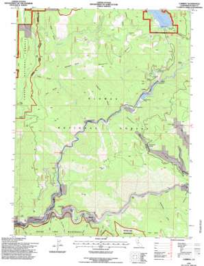
Caribou Topo Map California
To zoom in, hover over the map of Caribou
USGS Topo Quad 40121a2 - 1:24,000 scale
| Topo Map Name: | Caribou |
| USGS Topo Quad ID: | 40121a2 |
| Print Size: | ca. 21 1/4" wide x 27" high |
| Southeast Coordinates: | 40° N latitude / 121.125° W longitude |
| Map Center Coordinates: | 40.0625° N latitude / 121.1875° W longitude |
| U.S. State: | CA |
| Filename: | o40121a2.jpg |
| Download Map JPG Image: | Caribou topo map 1:24,000 scale |
| Map Type: | Topographic |
| Topo Series: | 7.5´ |
| Map Scale: | 1:24,000 |
| Source of Map Images: | United States Geological Survey (USGS) |
| Alternate Map Versions: |
Caribou CA 1979, updated 1979 Download PDF Buy paper map Caribou CA 1979, updated 1979 Download PDF Buy paper map Caribou CA 1979, updated 1979 Download PDF Buy paper map Caribou CA 1994, updated 1997 Download PDF Buy paper map Caribou CA 2012 Download PDF Buy paper map Caribou CA 2015 Download PDF Buy paper map |
| FStopo: | US Forest Service topo Caribou is available: Download FStopo PDF Download FStopo TIF |
1:24,000 Topo Quads surrounding Caribou
> Back to 40121a1 at 1:100,000 scale
> Back to 40120a1 at 1:250,000 scale
> Back to U.S. Topo Maps home
Caribou topo map: Gazetteer
Caribou: Bars
Indian Bar elevation 742m 2434′Missouri Bar elevation 717m 2352′
Pea Soup Bar elevation 728m 2388′
Poverty Bar elevation 752m 2467′
Smiths Bar elevation 716m 2349′
Twelve Mile Bar elevation 822m 2696′
Caribou: Basins
Fales Basin elevation 1487m 4878′Caribou: Capes
Smith Point elevation 711m 2332′Caribou: Dams
Butt Valley 93 Dam elevation 1264m 4146′Caribou Afterbay 97-120 Dam elevation 945m 3100′
Caribou: Flats
Oak Flat elevation 1195m 3920′Caribou: Gaps
Deadwood Saddle elevation 1399m 4589′Caribou: Mines
Red Rock Mine elevation 1553m 5095′Caribou: Populated Places
Belden elevation 677m 2221′Caribou elevation 1002m 3287′
Haven elevation 702m 2303′
Caribou: Reservoirs
Belden Forebay elevation 911m 2988′Butt Valley Reservoir elevation 1263m 4143′
Caribou: Ridges
Mosquito Ridge elevation 1688m 5538′Caribou: Springs
Soda Spring elevation 1183m 3881′Caribou: Streams
Benner Creek elevation 1224m 4015′Butt Creek elevation 965m 3166′
Clear Creek elevation 878m 2880′
Cold Brook Creek elevation 923m 3028′
Cottonwood Creek elevation 1260m 4133′
Deer Creek elevation 958m 3143′
Digger Creek elevation 871m 2857′
East Branch North Fork Feather River elevation 693m 2273′
French Creek elevation 911m 2988′
Middle Branch Mosquito Creek elevation 1320m 4330′
Mill Creek elevation 745m 2444′
Mosquito Creek elevation 805m 2641′
North Branch Mosquito Creek elevation 1263m 4143′
Owl Creek elevation 1211m 3973′
South Branch Mosquito Creek elevation 1320m 4330′
Squirrel Creek elevation 904m 2965′
Waller Creek elevation 725m 2378′
Caribou: Summits
Cherry Hill elevation 1756m 5761′Red Hill elevation 1928m 6325′
Caribou: Tunnels
Tunnel Twenty Five elevation 819m 2687′Tunnel Twenty Four elevation 769m 2522′
Tunnel Twenty Three elevation 777m 2549′
Caribou: Valleys
China Ravine elevation 1006m 3300′Cold Spring Ravine elevation 749m 2457′
Crablouse Ravine elevation 905m 2969′
Deadwood Canyon elevation 889m 2916′
Fern Canyon elevation 701m 2299′
French Ravine elevation 775m 2542′
Kellogg Ravine elevation 786m 2578′
McFarlane Ravine elevation 1046m 3431′
Oak Ravine elevation 733m 2404′
Rattlesnake Gulch elevation 838m 2749′
Serpentine Canyon elevation 736m 2414′
Silva Ravine elevation 983m 3225′
Soda Ravine elevation 1096m 3595′
Caribou digital topo map on disk
Buy this Caribou topo map showing relief, roads, GPS coordinates and other geographical features, as a high-resolution digital map file on DVD:


