Belden Topo Map California
To zoom in, hover over the map of Belden
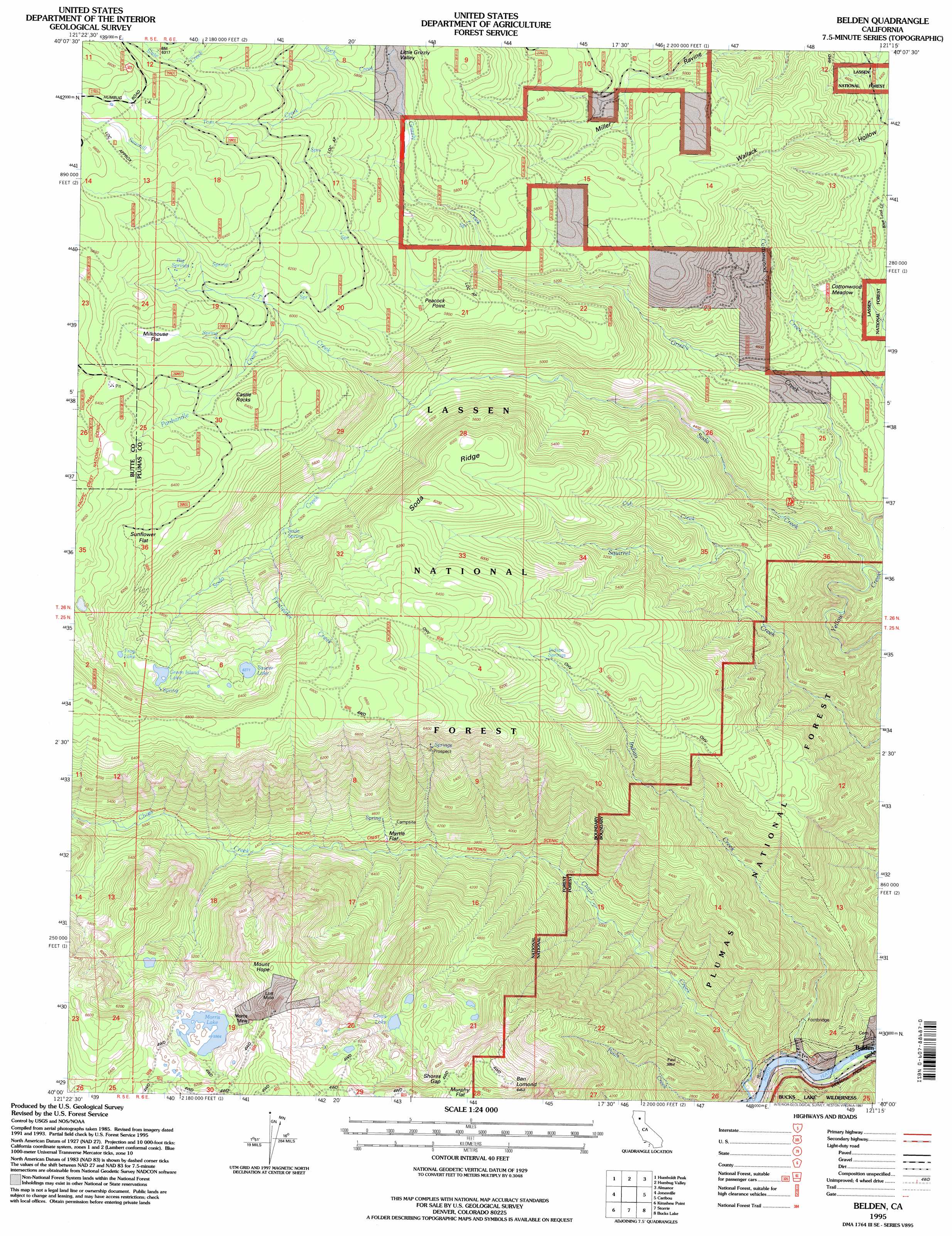
USGS Topo Quad 40121a3 - 1:24,000 scale
| Topo Map Name: | Belden |
| USGS Topo Quad ID: | 40121a3 |
| Print Size: | ca. 21 1/4" wide x 27" high |
| Southeast Coordinates: | 40° N latitude / 121.25° W longitude |
| Map Center Coordinates: | 40.0625° N latitude / 121.3125° W longitude |
| U.S. State: | CA |
| Filename: | o40121a3.jpg |
| Download Map JPG Image: | Belden topo map 1:24,000 scale |
| Map Type: | Topographic |
| Topo Series: | 7.5´ |
| Map Scale: | 1:24,000 |
| Source of Map Images: | United States Geological Survey (USGS) |
| Alternate Map Versions: |
Belden CA 1991, updated 1991 Download PDF Buy paper map Belden CA 1995, updated 1997 Download PDF Buy paper map Belden CA 2012 Download PDF Buy paper map Belden CA 2015 Download PDF Buy paper map |
| FStopo: | US Forest Service topo Belden is available: Download FStopo PDF Download FStopo TIF |
1:24,000 Topo Quads surrounding Belden
Mineral |
Childs Meadows |
Stover Mountain |
Chester |
Westwood West |
Onion Butte |
Humboldt Peak |
Humbug Valley |
Almanor |
Canyondam |
Butte Meadows |
Jonesville |
Belden |
Caribou |
Twain |
Stirling City |
Kimshew Point |
Storrie |
Bucks Lake |
Meadow Valley |
Paradise East |
Pulga |
Soapstone Hill |
Haskins Valley |
Dogwood Peak |
> Back to 40121a1 at 1:100,000 scale
> Back to 40120a1 at 1:250,000 scale
> Back to U.S. Topo Maps home
Belden topo map: Gazetteer
Belden: Flats
Cottonwood Meadow elevation 1330m 4363′Milkhouse Flat elevation 1933m 6341′
Myrtle Flat elevation 1271m 4169′
Sunflower Flat elevation 1857m 6092′
Belden: Gaps
Shores Gap elevation 1899m 6230′Belden: Lakes
Chips Lake elevation 1721m 5646′Frog Lake elevation 1883m 6177′
Green Island Lake elevation 1860m 6102′
Morris Lake elevation 1820m 5971′
Saucer Lake elevation 1912m 6272′
Belden: Mines
Lott Mine elevation 1919m 6295′Morris Mine elevation 1901m 6236′
Belden: Ridges
Peacock Point elevation 1794m 5885′Soda Ridge elevation 1830m 6003′
Belden: Springs
Big Springs elevation 1908m 6259′Indian Springs elevation 1821m 5974′
Soda Spring elevation 1591m 5219′
Belden: Streams
Cub Creek elevation 1394m 4573′Firstwater Creek elevation 1614m 5295′
Grizzly Creek elevation 1191m 3907′
Indian Creek elevation 674m 2211′
L-T Creek elevation 1523m 4996′
Panhandle Creek elevation 1824m 5984′
Rock Creek elevation 1741m 5711′
Sawmill Tom Creek elevation 1732m 5682′
Soda Creek elevation 1156m 3792′
Yellow Creek elevation 673m 2208′
Belden: Summits
Ben Lomond elevation 1945m 6381′Castle Rocks elevation 1961m 6433′
Humbug Summit elevation 2007m 6584′
Mount Hope elevation 2007m 6584′
Belden: Valleys
Belden Ravine elevation 695m 2280′Blue Lead Gulch elevation 1285m 4215′
Wallack Hollow elevation 1334m 4376′
Belden digital topo map on disk
Buy this Belden topo map showing relief, roads, GPS coordinates and other geographical features, as a high-resolution digital map file on DVD: