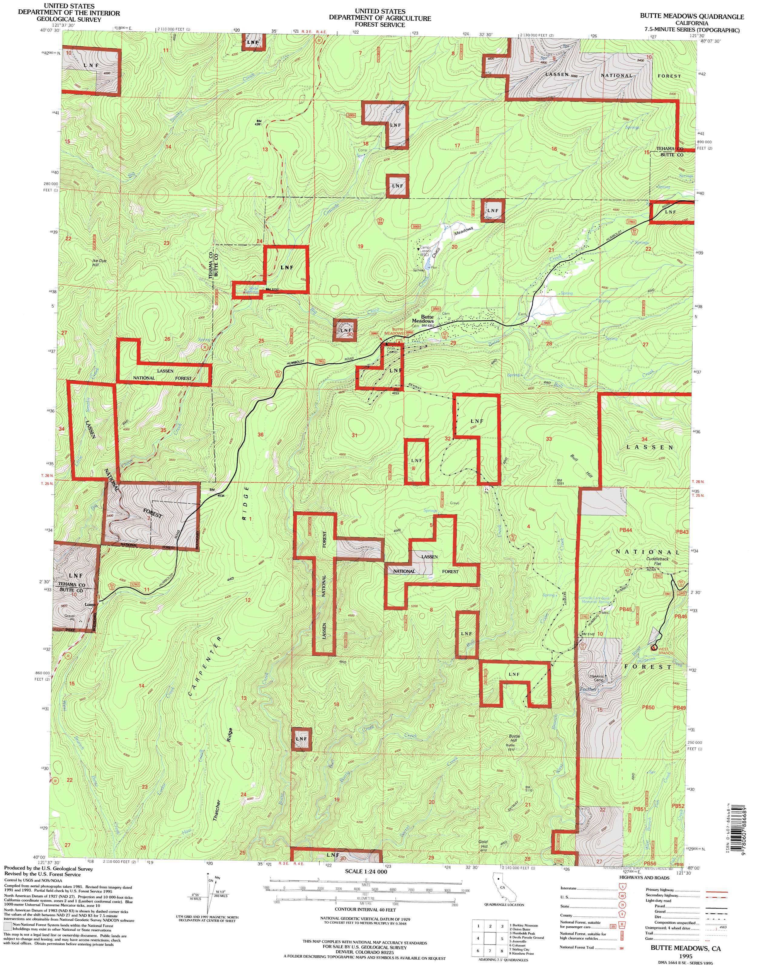
Butte Meadows Topo Map California
To zoom in, hover over the map of Butte Meadows
USGS Topo Quad 40121a5 - 1:24,000 scale
| Topo Map Name: | Butte Meadows |
| USGS Topo Quad ID: | 40121a5 |
| Print Size: | ca. 21 1/4" wide x 27" high |
| Southeast Coordinates: | 40° N latitude / 121.5° W longitude |
| Map Center Coordinates: | 40.0625° N latitude / 121.5625° W longitude |
| U.S. State: | CA |
| Filename: | o40121a5.jpg |
| Download Map JPG Image: | Butte Meadows topo map 1:24,000 scale |
| Map Type: | Topographic |
| Topo Series: | 7.5´ |
| Map Scale: | 1:24,000 |
| Source of Map Images: | United States Geological Survey (USGS) |
| Alternate Map Versions: |
Butte Meadows CA 1991, updated 1991 Download PDF Buy paper map Butte Meadows CA 1995, updated 1997 Download PDF Buy paper map Butte Meadows CA 2012 Download PDF Buy paper map Butte Meadows CA 2015 Download PDF Buy paper map |
| FStopo: | US Forest Service topo Butte Meadows is available: Download FStopo PDF Download FStopo TIF |
1:24,000 Topo Quads surrounding Butte Meadows
Finley Butte |
Lyonsville |
Mineral |
Childs Meadows |
Stover Mountain |
Panther Spring |
Barkley Mountain |
Onion Butte |
Humboldt Peak |
Humbug Valley |
Ishi Caves |
Devils Parade Ground |
Butte Meadows |
Jonesville |
Belden |
Campbell Mound |
Cohasset |
Stirling City |
Kimshew Point |
Storrie |
Richardson Springs |
Paradise West |
Paradise East |
Pulga |
Soapstone Hill |
> Back to 40121a1 at 1:100,000 scale
> Back to 40120a1 at 1:250,000 scale
> Back to U.S. Topo Maps home
Butte Meadows topo map: Gazetteer
Butte Meadows: Flats
Chico Meadows elevation 1295m 4248′Cuddleback Flat elevation 1571m 5154′
Butte Meadows: Populated Places
Butte Meadows elevation 1323m 4340′Glenburn elevation 1559m 5114′
Lomo elevation 1152m 3779′
Butte Meadows: Post Offices
Butte Meadows Post Office (historical) elevation 1323m 4340′Butte Meadows: Ridges
Carpenter Ridge elevation 1429m 4688′Thatcher Ridge elevation 1271m 4169′
Butte Meadows: Springs
Cornelia Lott Sank Memorial Spring elevation 1531m 5022′Soda Springs elevation 1142m 3746′
Butte Meadows: Streams
Bolt Creek elevation 1330m 4363′Bottle Creek elevation 1093m 3585′
Bull Creek elevation 1019m 3343′
Cascade Creek elevation 1134m 3720′
Cedar Creek elevation 997m 3270′
Coon Creek elevation 1406m 4612′
Philbrook Creek elevation 1471m 4826′
Secret Creek elevation 1050m 3444′
Butte Meadows: Summits
Bottle Hill elevation 1609m 5278′Bull Hill elevation 1624m 5328′
Gold Hill elevation 1527m 5009′
Ike Dye Hill elevation 1338m 4389′
Butte Meadows digital topo map on disk
Buy this Butte Meadows topo map showing relief, roads, GPS coordinates and other geographical features, as a high-resolution digital map file on DVD: