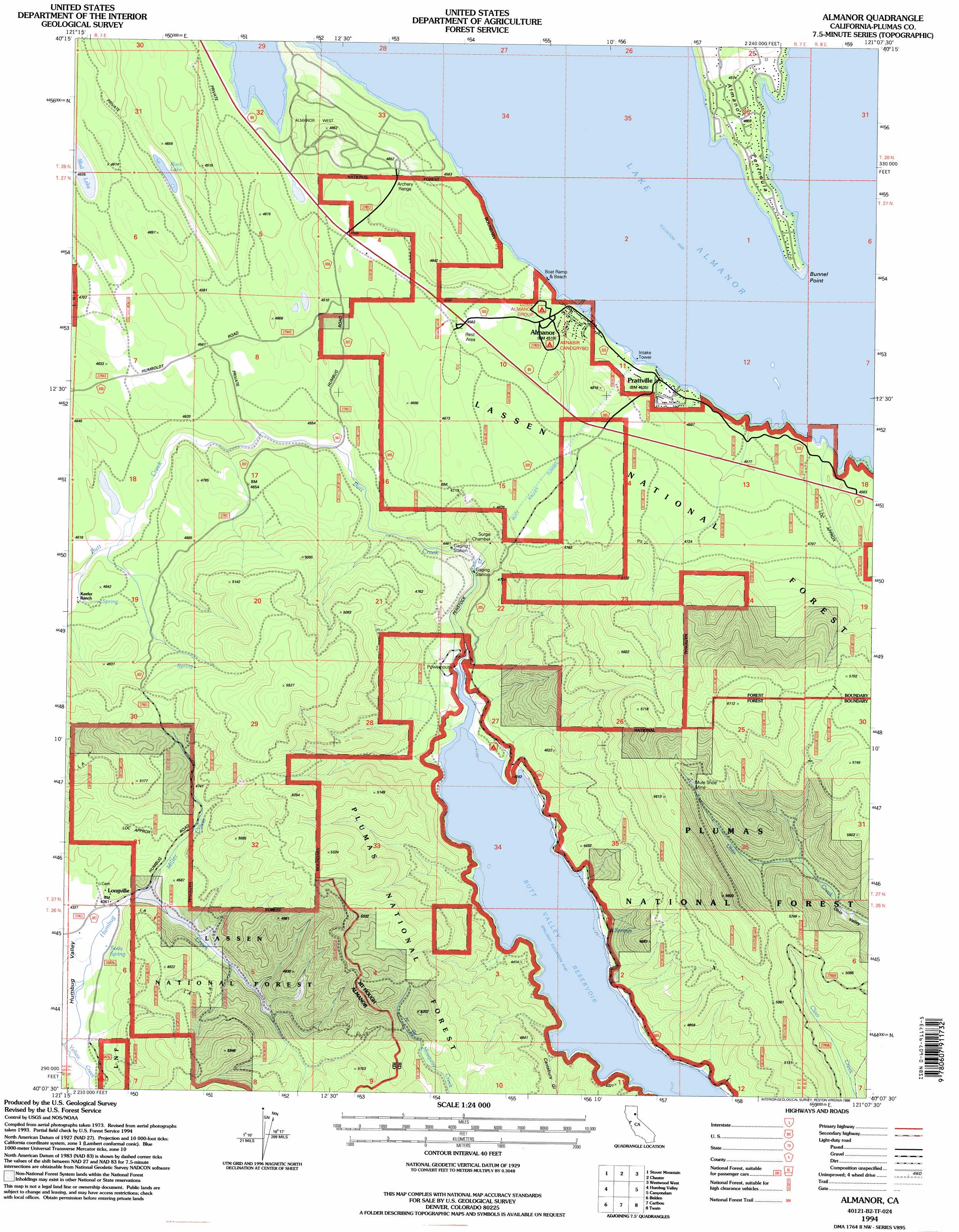
Almanor Topo Map California
To zoom in, hover over the map of Almanor
USGS Topo Quad 40121b2 - 1:24,000 scale
| Topo Map Name: | Almanor |
| USGS Topo Quad ID: | 40121b2 |
| Print Size: | ca. 21 1/4" wide x 27" high |
| Southeast Coordinates: | 40.125° N latitude / 121.125° W longitude |
| Map Center Coordinates: | 40.1875° N latitude / 121.1875° W longitude |
| U.S. State: | CA |
| Filename: | o40121b2.jpg |
| Download Map JPG Image: | Almanor topo map 1:24,000 scale |
| Map Type: | Topographic |
| Topo Series: | 7.5´ |
| Map Scale: | 1:24,000 |
| Source of Map Images: | United States Geological Survey (USGS) |
| Alternate Map Versions: |
Almanor CA 1979, updated 1979 Download PDF Buy paper map Almanor CA 1979, updated 1979 Download PDF Buy paper map Almanor CA 1994, updated 1998 Download PDF Buy paper map Almanor CA 1994, updated 1998 Download PDF Buy paper map Almanor CA 2012 Download PDF Buy paper map Almanor CA 2015 Download PDF Buy paper map |
| FStopo: | US Forest Service topo Almanor is available: Download FStopo PDF Download FStopo TIF |
1:24,000 Topo Quads surrounding Almanor
Reading Peak |
Mount Harkness |
Red Cinder |
Swain Mountain |
Pegleg Mountain |
Childs Meadows |
Stover Mountain |
Chester |
Westwood West |
Westwood East |
Humboldt Peak |
Humbug Valley |
Almanor |
Canyondam |
Greenville |
Jonesville |
Belden |
Caribou |
Twain |
Crescent Mills |
Kimshew Point |
Storrie |
Bucks Lake |
Meadow Valley |
Quincy |
> Back to 40121a1 at 1:100,000 scale
> Back to 40120a1 at 1:250,000 scale
> Back to U.S. Topo Maps home
Almanor topo map: Gazetteer
Almanor: Capes
Almanor Peninsula elevation 1393m 4570′Bunnel Point elevation 1374m 4507′
Almanor: Lakes
Mud Lake elevation 1411m 4629′Rock Lake elevation 1375m 4511′
Almanor: Mines
Mule Shoe Mine elevation 1546m 5072′Almanor: Populated Places
Almanor elevation 1388m 4553′Lake Almanor West elevation 1422m 4665′
Longville elevation 1341m 4399′
Prattville elevation 1382m 4534′
Almanor: Post Offices
Almanor Post Office (historical) elevation 1388m 4553′Almanor: Springs
Soda Spring elevation 1326m 4350′Almanor: Streams
Miller Creek elevation 1333m 4373′Almanor: Tunnels
Butt Valley Tunnel elevation 1430m 4691′Almanor: Valleys
Cantebury Gulch elevation 1272m 4173′Almanor digital topo map on disk
Buy this Almanor topo map showing relief, roads, GPS coordinates and other geographical features, as a high-resolution digital map file on DVD: