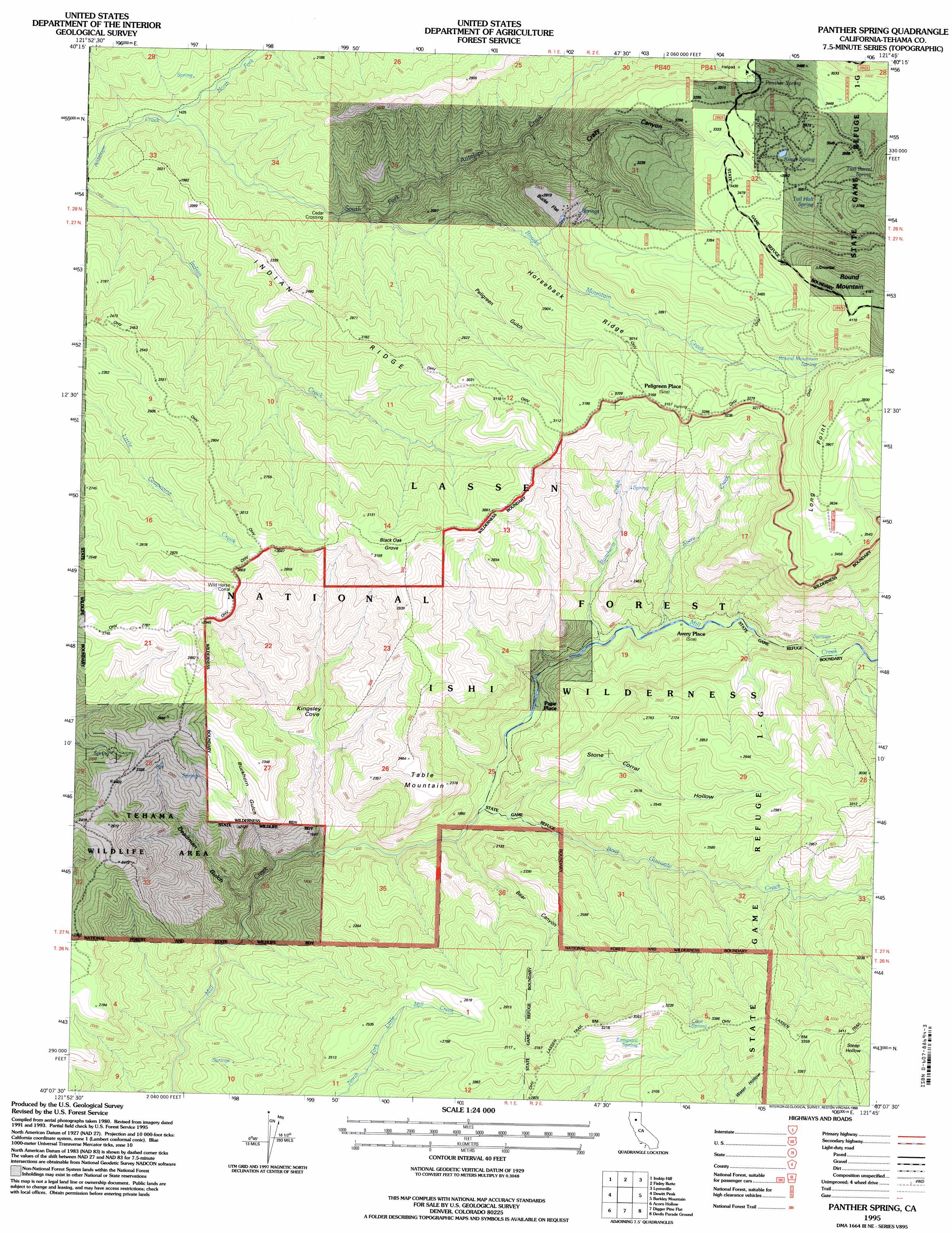
Panther Spring Topo Map California
To zoom in, hover over the map of Panther Spring
USGS Topo Quad 40121b7 - 1:24,000 scale
| Topo Map Name: | Panther Spring |
| USGS Topo Quad ID: | 40121b7 |
| Print Size: | ca. 21 1/4" wide x 27" high |
| Southeast Coordinates: | 40.125° N latitude / 121.75° W longitude |
| Map Center Coordinates: | 40.1875° N latitude / 121.8125° W longitude |
| U.S. State: | CA |
| Filename: | o40121b7.jpg |
| Download Map JPG Image: | Panther Spring topo map 1:24,000 scale |
| Map Type: | Topographic |
| Topo Series: | 7.5´ |
| Map Scale: | 1:24,000 |
| Source of Map Images: | United States Geological Survey (USGS) |
| Alternate Map Versions: |
Panther Spring CA 1986, updated 1986 Download PDF Buy paper map Panther Spring CA 1995, updated 1998 Download PDF Buy paper map Panther Spring CA 2012 Download PDF Buy paper map Panther Spring CA 2015 Download PDF Buy paper map |
| FStopo: | US Forest Service topo Panther Spring is available: Download FStopo PDF Download FStopo TIF |
1:24,000 Topo Quads surrounding Panther Spring
Tuscan Buttes Ne |
Shingletown |
Manton |
Grays Peak |
Lassen Peak |
Dales |
Inskip Hill |
Finley Butte |
Lyonsville |
Mineral |
Tuscan Springs |
Dewitt Peak |
Panther Spring |
Barkley Mountain |
Onion Butte |
Los Molinos |
Acorn Hollow |
Ishi Caves |
Devils Parade Ground |
Butte Meadows |
Vina |
Richardson Springs Nw |
Campbell Mound |
Cohasset |
Stirling City |
> Back to 40121a1 at 1:100,000 scale
> Back to 40120a1 at 1:250,000 scale
> Back to U.S. Topo Maps home
Panther Spring topo map: Gazetteer
Panther Spring: Capes
Long Point elevation 1042m 3418′Panther Spring: Crossings
Blunkall Crossing elevation 383m 1256′Cedar Crossing elevation 533m 1748′
Panther Spring: Flats
Bucks Flat elevation 864m 2834′Little Bucks Flat elevation 896m 2939′
Panther Spring: Populated Places
Avery Place elevation 513m 1683′Pape Place elevation 490m 1607′
Peligreen Place elevation 960m 3149′
Panther Spring: Ridges
Horseback Ridge elevation 878m 2880′Indian Ridge elevation 835m 2739′
Panther Spring: Springs
Cave Spring elevation 1003m 3290′Davison Spring elevation 934m 3064′
Emigrant Spring elevation 865m 2837′
Knass Spring elevation 1058m 3471′
Panther Spring elevation 1001m 3284′
Round Mountain Spring elevation 1104m 3622′
Tail Holt Spring elevation 1062m 3484′
Two-Barrel Spring elevation 1134m 3720′
Panther Spring: Streams
Avery Creek elevation 501m 1643′Boat Gunwale Creek elevation 447m 1466′
North Fork Antelope Creek elevation 451m 1479′
Rancheria Creek elevation 484m 1587′
Round Mountain Creek elevation 552m 1811′
South Fork Antelope Creek elevation 430m 1410′
Panther Spring: Summits
Round Mountain elevation 1231m 4038′Table Mountain elevation 713m 2339′
Panther Spring: Valleys
Bear Canyon elevation 464m 1522′Buckhorn Gulch elevation 409m 1341′
Crazy Canyon elevation 644m 2112′
Deadman Gulch elevation 392m 1286′
Kingsley Cove elevation 420m 1377′
Peligreen Gulch elevation 579m 1899′
Steep Hollow elevation 1031m 3382′
Stone Corral Hollow elevation 492m 1614′
Panther Spring: Woods
Black Oak Grove elevation 766m 2513′Panther Spring digital topo map on disk
Buy this Panther Spring topo map showing relief, roads, GPS coordinates and other geographical features, as a high-resolution digital map file on DVD: