Finley Butte Topo Map California
To zoom in, hover over the map of Finley Butte
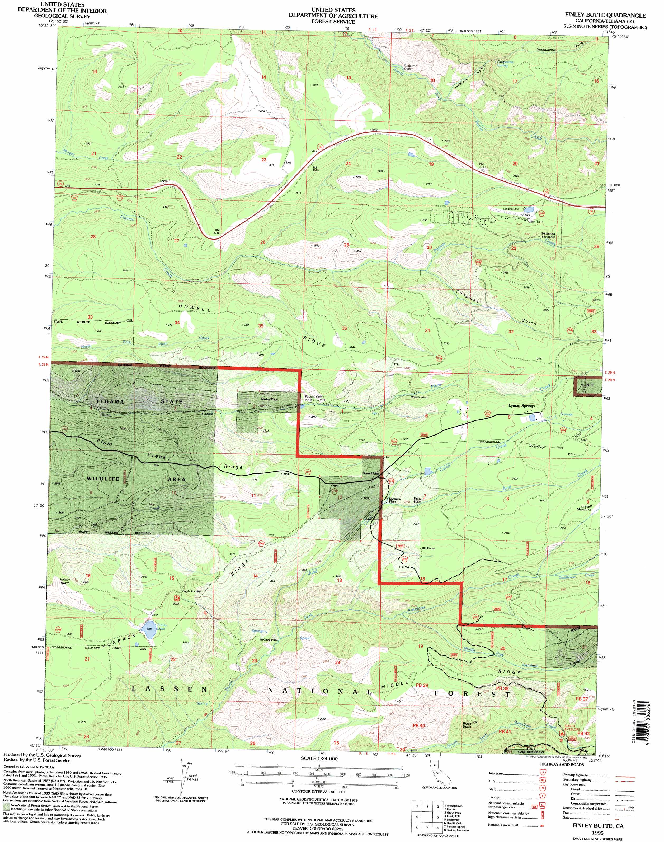
USGS Topo Quad 40121c7 - 1:24,000 scale
| Topo Map Name: | Finley Butte |
| USGS Topo Quad ID: | 40121c7 |
| Print Size: | ca. 21 1/4" wide x 27" high |
| Southeast Coordinates: | 40.25° N latitude / 121.75° W longitude |
| Map Center Coordinates: | 40.3125° N latitude / 121.8125° W longitude |
| U.S. State: | CA |
| Filename: | o40121c7.jpg |
| Download Map JPG Image: | Finley Butte topo map 1:24,000 scale |
| Map Type: | Topographic |
| Topo Series: | 7.5´ |
| Map Scale: | 1:24,000 |
| Source of Map Images: | United States Geological Survey (USGS) |
| Alternate Map Versions: |
Finley Butte CA 1985, updated 1985 Download PDF Buy paper map Finley Butte CA 1995, updated 1998 Download PDF Buy paper map Finley Butte CA 1995, updated 1998 Download PDF Buy paper map Finley Butte CA 2012 Download PDF Buy paper map Finley Butte CA 2015 Download PDF Buy paper map |
| FStopo: | US Forest Service topo Finley Butte is available: Download FStopo PDF Download FStopo TIF |
1:24,000 Topo Quads surrounding Finley Butte
Clough Gulch |
Inwood |
Hagaman Gulch |
Viola |
Manzanita Lake |
Tuscan Buttes Ne |
Shingletown |
Manton |
Grays Peak |
Lassen Peak |
Dales |
Inskip Hill |
Finley Butte |
Lyonsville |
Mineral |
Tuscan Springs |
Dewitt Peak |
Panther Spring |
Barkley Mountain |
Onion Butte |
Los Molinos |
Acorn Hollow |
Ishi Caves |
Devils Parade Ground |
Butte Meadows |
> Back to 40121a1 at 1:100,000 scale
> Back to 40120a1 at 1:250,000 scale
> Back to U.S. Topo Maps home
Finley Butte topo map: Gazetteer
Finley Butte: Airports
Ponderosa Sky Ranch elevation 1043m 3421′Finley Butte: Bridges
High Trestle elevation 837m 2746′Finley Butte: Lakes
Finley Lake elevation 852m 2795′Finley Butte: Populated Places
Dantuma Place elevation 932m 3057′Finley Place elevation 962m 3156′
Lyman Springs elevation 1051m 3448′
Marian Place elevation 797m 2614′
McClure Place elevation 573m 1879′
Finley Butte: Ridges
Howell Ridge elevation 862m 2828′Middle Ridge elevation 1101m 3612′
Finley Butte: Springs
Grapevine Spring elevation 1058m 3471′Lyman Springs elevation 1054m 3458′
Finley Butte: Streams
Deadhorse Creek elevation 944m 3097′Judd Creek elevation 570m 1870′
Middle Fork Antelope Creek elevation 773m 2536′
Finley Butte: Summits
Black Butte elevation 1047m 3435′Finley Butte elevation 859m 2818′
Finley Butte: Valleys
Chapman Gulch elevation 814m 2670′Grapevine Canyon elevation 685m 2247′
Snoqualmie Gulch elevation 906m 2972′
Finley Butte digital topo map on disk
Buy this Finley Butte topo map showing relief, roads, GPS coordinates and other geographical features, as a high-resolution digital map file on DVD: