Reading Peak Topo Map California
To zoom in, hover over the map of Reading Peak
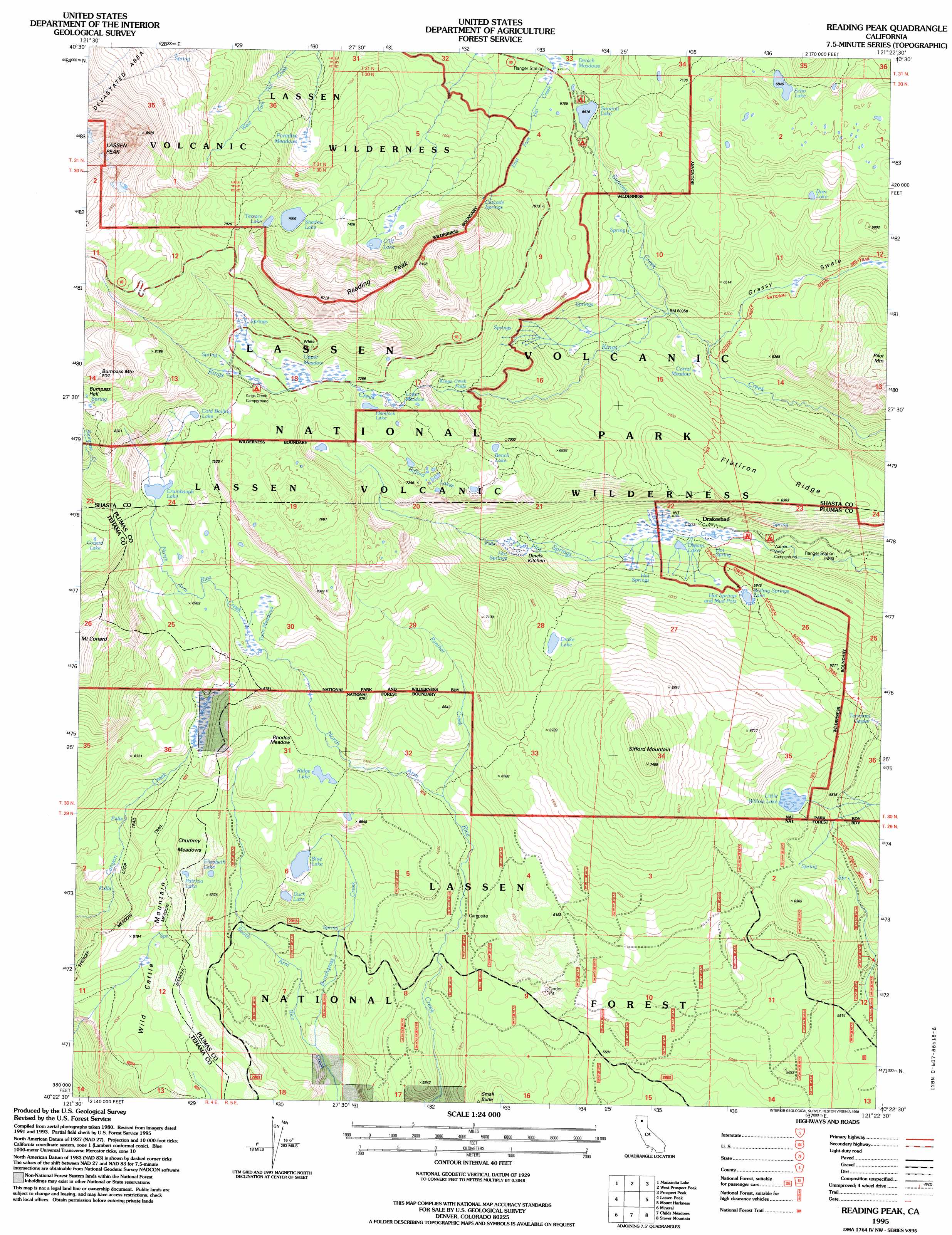
USGS Topo Quad 40121d4 - 1:24,000 scale
| Topo Map Name: | Reading Peak |
| USGS Topo Quad ID: | 40121d4 |
| Print Size: | ca. 21 1/4" wide x 27" high |
| Southeast Coordinates: | 40.375° N latitude / 121.375° W longitude |
| Map Center Coordinates: | 40.4375° N latitude / 121.4375° W longitude |
| U.S. State: | CA |
| Filename: | o40121d4.jpg |
| Download Map JPG Image: | Reading Peak topo map 1:24,000 scale |
| Map Type: | Topographic |
| Topo Series: | 7.5´ |
| Map Scale: | 1:24,000 |
| Source of Map Images: | United States Geological Survey (USGS) |
| Alternate Map Versions: |
Reading Peak CA 1985, updated 1985 Download PDF Buy paper map Reading Peak CA 1995, updated 1998 Download PDF Buy paper map Reading Peak CA 2012 Download PDF Buy paper map Reading Peak CA 2015 Download PDF Buy paper map |
| FStopo: | US Forest Service topo Reading Peak is available: Download FStopo PDF Download FStopo TIF |
1:24,000 Topo Quads surrounding Reading Peak
Jacks Backbone |
Thousand Lakes Valley |
Old Station |
Swains Hole |
Poison Lake |
Viola |
Manzanita Lake |
West Prospect Peak |
Prospect Peak |
Bogard Buttes |
Grays Peak |
Lassen Peak |
Reading Peak |
Mount Harkness |
Red Cinder |
Lyonsville |
Mineral |
Childs Meadows |
Stover Mountain |
Chester |
Barkley Mountain |
Onion Butte |
Humboldt Peak |
Humbug Valley |
Almanor |
> Back to 40121a1 at 1:100,000 scale
> Back to 40120a1 at 1:250,000 scale
> Back to U.S. Topo Maps home
Reading Peak topo map: Gazetteer
Reading Peak: Falls
Kings Creek Falls elevation 2088m 6850′Reading Peak: Flats
Chummy Meadows elevation 1963m 6440′Corral Meadow elevation 1825m 5987′
Lower Kings Creek Meadow elevation 2189m 7181′
Lower Meadow elevation 2196m 7204′
Rhodes Meadow elevation 1999m 6558′
Spencer Meadow elevation 2079m 6820′
Twin Meadows elevation 2064m 6771′
Upper Kings Creek Meadow elevation 2231m 7319′
Upper Meadow elevation 2247m 7372′
Reading Peak: Lakes
Bench Lake elevation 2119m 6952′Blue Lake elevation 1915m 6282′
Boiling Springs Lake elevation 1802m 5912′
Cliff Lake elevation 2241m 7352′
Cold Boiling Lake elevation 2265m 7431′
Conard Lake elevation 2204m 7230′
Crumbaugh Lake elevation 2200m 7217′
Deer Lake elevation 2023m 6637′
Drake Lake elevation 1982m 6502′
Dream Lake elevation 1747m 5731′
Duck Lake elevation 1889m 6197′
Echo Lake elevation 2088m 6850′
Elizabeth Lake elevation 1950m 6397′
Hemlock Lake elevation 2205m 7234′
Little Willow Lake elevation 1837m 6026′
Patricia Lake elevation 1973m 6473′
Ridge Lake elevation 1980m 6496′
Shadow Lake elevation 2320m 7611′
Sifford Lakes elevation 2193m 7194′
Summit Lake elevation 2036m 6679′
Terrace Lake elevation 2351m 7713′
Reading Peak: Parks
Lassen Volcanic National Park elevation 2035m 6676′Reading Peak: Populated Places
Drakesbad elevation 1739m 5705′Reading Peak: Ridges
Flatiron Ridge elevation 1886m 6187′Reading Peak: Springs
Cascade Springs elevation 2199m 7214′Devils Kitchen elevation 1869m 6131′
Drakes Springs elevation 1773m 5816′
Terminal Geyser elevation 1785m 5856′
Reading Peak: Streams
Bunchgrass Creek elevation 1690m 5544′Panther Creek elevation 1865m 6118′
Summit Creek elevation 1857m 6092′
Reading Peak: Summits
Bumpass Mountain elevation 2664m 8740′Reading Peak elevation 2647m 8684′
Sifford Mountain elevation 2250m 7381′
Reading Peak: Trails
Childs Meadows Trail elevation 1870m 6135′Growler Trail elevation 1881m 6171′
Hanna Trail elevation 1884m 6181′
Spencer Meadow Trail elevation 1895m 6217′
Reading Peak: Valleys
Grassy Swale elevation 1887m 6190′Reading Peak digital topo map on disk
Buy this Reading Peak topo map showing relief, roads, GPS coordinates and other geographical features, as a high-resolution digital map file on DVD: