Manton Topo Map California
To zoom in, hover over the map of Manton
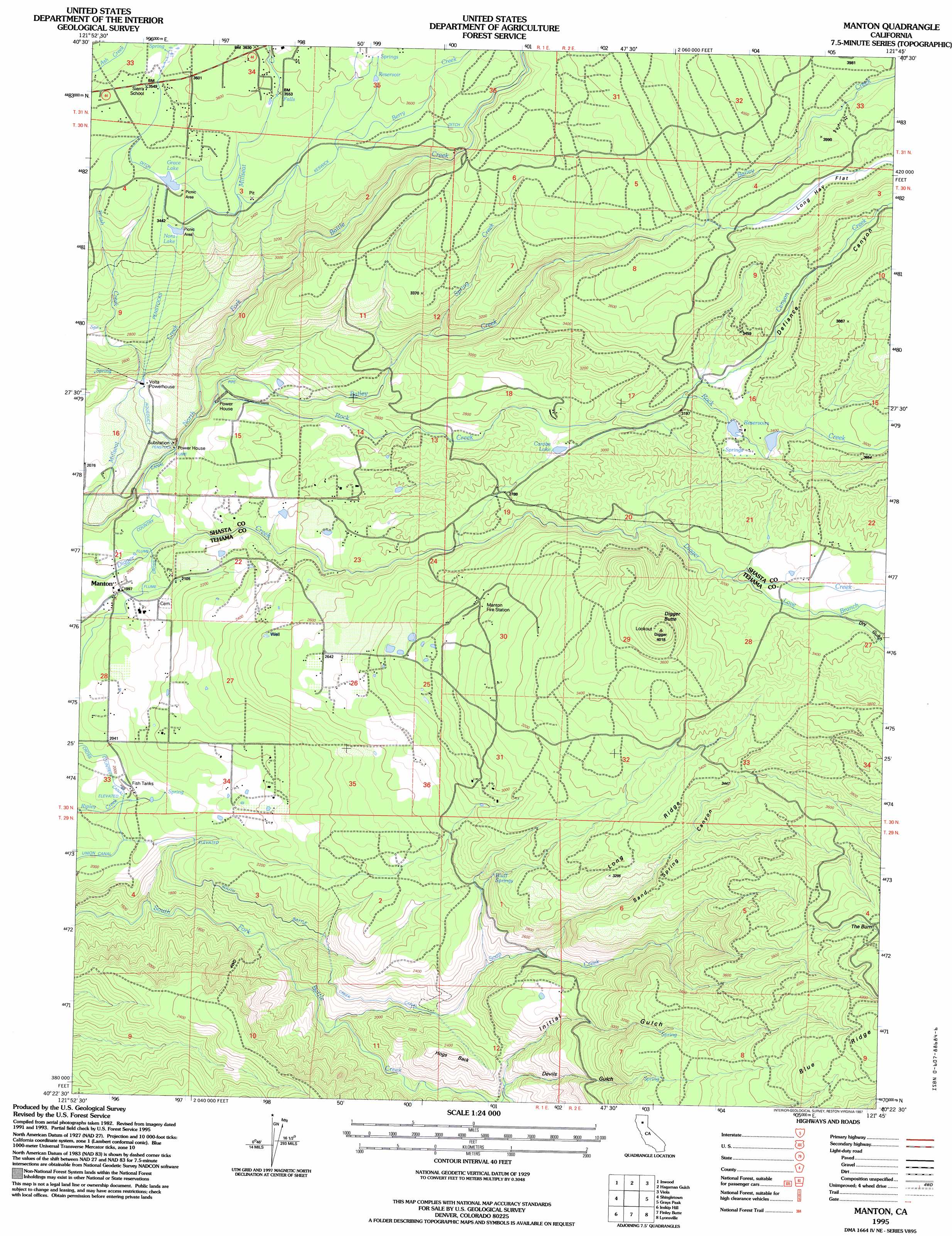
USGS Topo Quad 40121d7 - 1:24,000 scale
| Topo Map Name: | Manton |
| USGS Topo Quad ID: | 40121d7 |
| Print Size: | ca. 21 1/4" wide x 27" high |
| Southeast Coordinates: | 40.375° N latitude / 121.75° W longitude |
| Map Center Coordinates: | 40.4375° N latitude / 121.8125° W longitude |
| U.S. State: | CA |
| Filename: | o40121d7.jpg |
| Download Map JPG Image: | Manton topo map 1:24,000 scale |
| Map Type: | Topographic |
| Topo Series: | 7.5´ |
| Map Scale: | 1:24,000 |
| Source of Map Images: | United States Geological Survey (USGS) |
| Alternate Map Versions: |
Manton CA 1985, updated 1986 Download PDF Buy paper map Manton CA 1995, updated 1997 Download PDF Buy paper map Manton CA 1995, updated 1997 Download PDF Buy paper map Manton CA 2012 Download PDF Buy paper map Manton CA 2015 Download PDF Buy paper map |
| FStopo: | US Forest Service topo Manton is available: Download FStopo PDF Download FStopo TIF |
1:24,000 Topo Quads surrounding Manton
Oak Run |
Whitmore |
Miller Mountain |
Jacks Backbone |
Thousand Lakes Valley |
Clough Gulch |
Inwood |
Hagaman Gulch |
Viola |
Manzanita Lake |
Tuscan Buttes Ne |
Shingletown |
Manton |
Grays Peak |
Lassen Peak |
Dales |
Inskip Hill |
Finley Butte |
Lyonsville |
Mineral |
Tuscan Springs |
Dewitt Peak |
Panther Spring |
Barkley Mountain |
Onion Butte |
> Back to 40121a1 at 1:100,000 scale
> Back to 40120a1 at 1:250,000 scale
> Back to U.S. Topo Maps home
Manton topo map: Gazetteer
Manton: Areas
The Burn elevation 1267m 4156′Manton: Canals
Cross Country Ditch elevation 635m 2083′Keswick Ditch elevation 1074m 3523′
Union Canal elevation 635m 2083′
Manton: Dams
Null 1221 Dam elevation 1008m 3307′Manton: Flats
Long Hay Flat elevation 1169m 3835′Manton: Lakes
Carobe Lake elevation 885m 2903′Grace Lake elevation 1064m 3490′
Nora Lake elevation 1045m 3428′
Manton: Populated Places
Manton elevation 612m 2007′Manton: Ridges
Hogs Back elevation 710m 2329′Long Ridge elevation 1014m 3326′
Manton: Springs
Bluff Springs elevation 785m 2575′Manton: Streams
Bailey Creek elevation 685m 2247′Berry Creek elevation 1051m 3448′
Brush Creek elevation 671m 2201′
Canyon Creek elevation 965m 3166′
Love Branch elevation 963m 3159′
Rock Creek elevation 686m 2250′
Soap Creek elevation 640m 2099′
Spring Creek elevation 855m 2805′
Manton: Summits
Digger Butte elevation 1212m 3976′Manton: Valleys
Devils Gulch elevation 643m 2109′Dry Gulch elevation 1018m 3339′
Initial Gulch elevation 660m 2165′
Sand Spring Canyon elevation 773m 2536′
Manton digital topo map on disk
Buy this Manton topo map showing relief, roads, GPS coordinates and other geographical features, as a high-resolution digital map file on DVD: