Miller Mountain Topo Map California
To zoom in, hover over the map of Miller Mountain
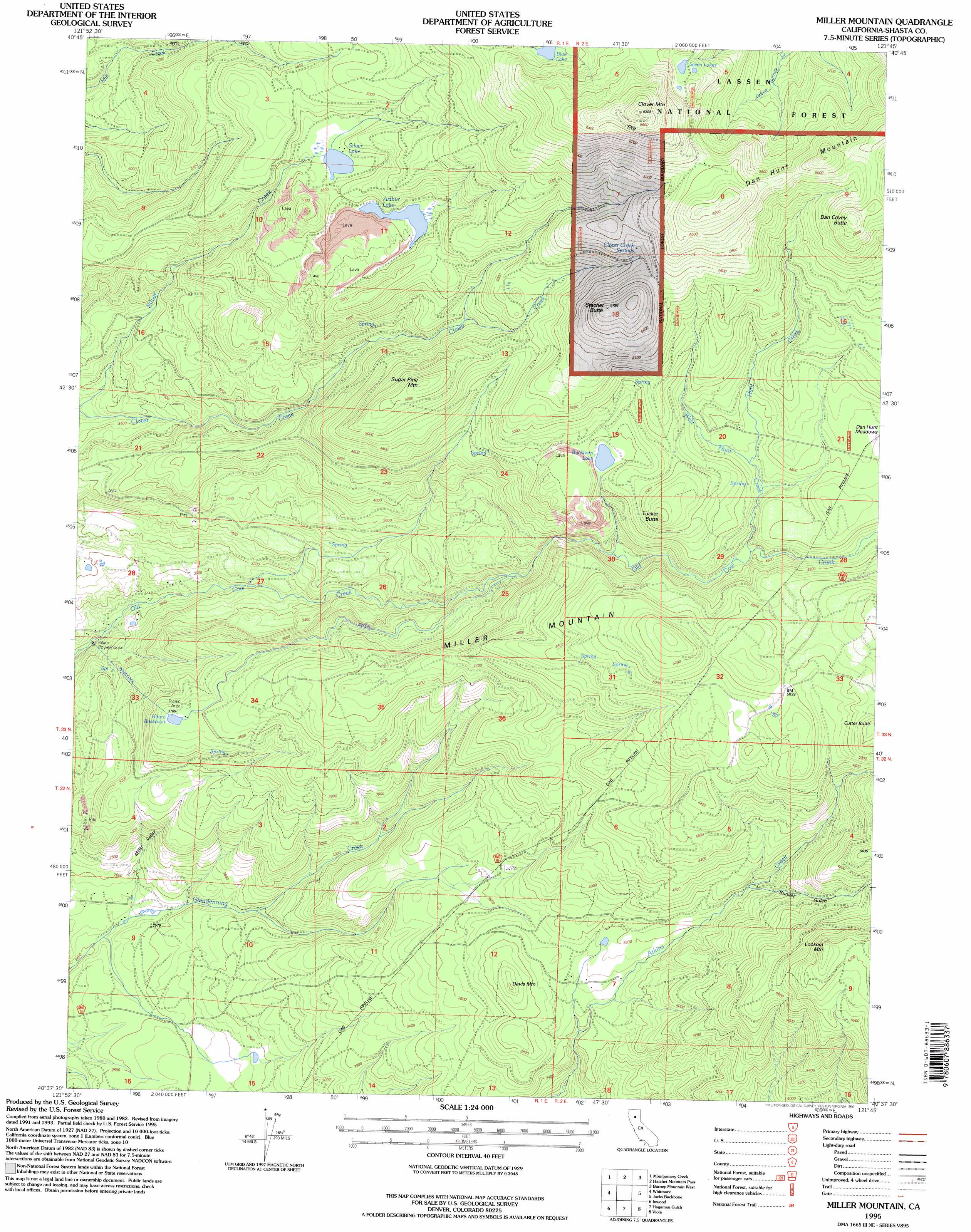
USGS Topo Quad 40121f7 - 1:24,000 scale
| Topo Map Name: | Miller Mountain |
| USGS Topo Quad ID: | 40121f7 |
| Print Size: | ca. 21 1/4" wide x 27" high |
| Southeast Coordinates: | 40.625° N latitude / 121.75° W longitude |
| Map Center Coordinates: | 40.6875° N latitude / 121.8125° W longitude |
| U.S. State: | CA |
| Filename: | o40121f7.jpg |
| Download Map JPG Image: | Miller Mountain topo map 1:24,000 scale |
| Map Type: | Topographic |
| Topo Series: | 7.5´ |
| Map Scale: | 1:24,000 |
| Source of Map Images: | United States Geological Survey (USGS) |
| Alternate Map Versions: |
Miller Mountain CA 1985, updated 1985 Download PDF Buy paper map Miller Mountain CA 1995, updated 1997 Download PDF Buy paper map Miller Mountain CA 2012 Download PDF Buy paper map Miller Mountain CA 2015 Download PDF Buy paper map |
| FStopo: | US Forest Service topo Miller Mountain is available: Download FStopo PDF Download FStopo TIF |
1:24,000 Topo Quads surrounding Miller Mountain
Goose Gap |
Roaring Creek |
Chalk Mountain |
Burney |
Cassel |
Devils Rock |
Montgomery Creek |
Hatchet Mountain Pass |
Burney Mountain West |
Burney Mountain East |
Oak Run |
Whitmore |
Miller Mountain |
Jacks Backbone |
Thousand Lakes Valley |
Clough Gulch |
Inwood |
Hagaman Gulch |
Viola |
Manzanita Lake |
Tuscan Buttes Ne |
Shingletown |
Manton |
Grays Peak |
Lassen Peak |
> Back to 40121e1 at 1:100,000 scale
> Back to 40120a1 at 1:250,000 scale
> Back to U.S. Topo Maps home
Miller Mountain topo map: Gazetteer
Miller Mountain: Flats
Dan Hunt Meadows elevation 1483m 4865′Miller Mountain: Lakes
Arthur Lake elevation 1445m 4740′Blue Lake elevation 1725m 5659′
Buckhorn Lake elevation 1458m 4783′
Seven Lakes elevation 1804m 5918′
Silver Lake elevation 1444m 4737′
Miller Mountain: Reservoirs
Kilarc Reservoir elevation 1128m 3700′Miller Mountain: Springs
Clover Creek Springs elevation 1673m 5488′Miller Mountain: Streams
Hunt Creek elevation 1430m 4691′West Hunt Creek elevation 1387m 4550′
Miller Mountain: Summits
Clover Mountain elevation 2066m 6778′Cutter Butte elevation 1601m 5252′
Dan Covey Butte elevation 1871m 6138′
Dan Hunt Mountain elevation 1892m 6207′
Davis Mountain elevation 1203m 3946′
Lookout Mountain elevation 1622m 5321′
Miller Mountain elevation 1620m 5314′
Stacher Butte elevation 1759m 5770′
Sugar Pine Mountain elevation 1615m 5298′
Tucker Butte elevation 1599m 5246′
Miller Mountain: Valleys
Miller Valley elevation 760m 2493′Sunset Gulch elevation 1226m 4022′
Miller Mountain digital topo map on disk
Buy this Miller Mountain topo map showing relief, roads, GPS coordinates and other geographical features, as a high-resolution digital map file on DVD: