Montgomery Creek Topo Map California
To zoom in, hover over the map of Montgomery Creek
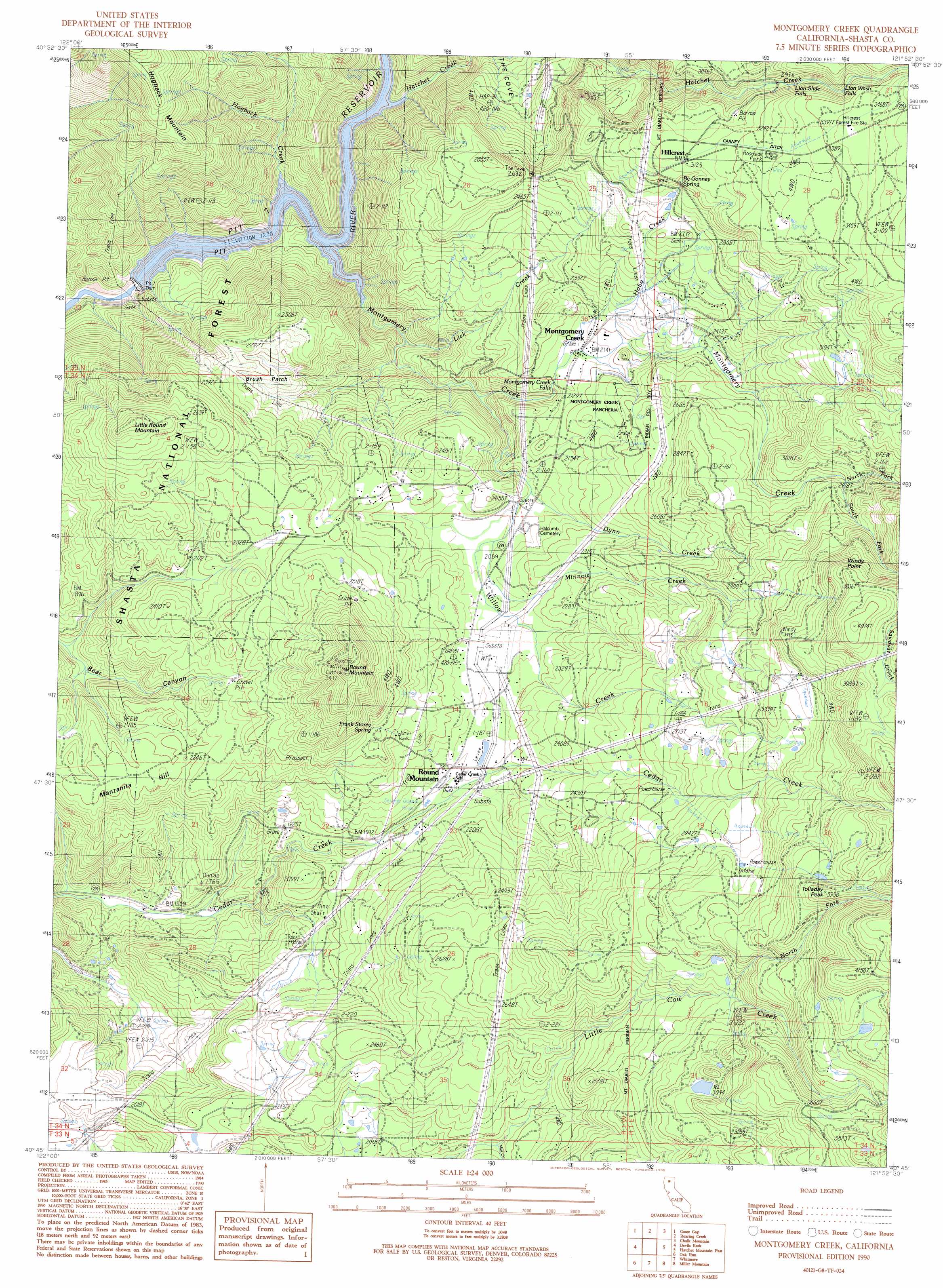
USGS Topo Quad 40121g8 - 1:24,000 scale
| Topo Map Name: | Montgomery Creek |
| USGS Topo Quad ID: | 40121g8 |
| Print Size: | ca. 21 1/4" wide x 27" high |
| Southeast Coordinates: | 40.75° N latitude / 121.875° W longitude |
| Map Center Coordinates: | 40.8125° N latitude / 121.9375° W longitude |
| U.S. State: | CA |
| Filename: | o40121g8.jpg |
| Download Map JPG Image: | Montgomery Creek topo map 1:24,000 scale |
| Map Type: | Topographic |
| Topo Series: | 7.5´ |
| Map Scale: | 1:24,000 |
| Source of Map Images: | United States Geological Survey (USGS) |
| Alternate Map Versions: |
Montgomery Creek CA 1990, updated 1990 Download PDF Buy paper map Montgomery Creek CA 1990, updated 1990 Download PDF Buy paper map Montgomery Creek CA 1998, updated 2003 Download PDF Buy paper map Montgomery Creek CA 1998, updated 2003 Download PDF Buy paper map Montgomery Creek CA 2012 Download PDF Buy paper map Montgomery Creek CA 2015 Download PDF Buy paper map |
| FStopo: | US Forest Service topo Montgomery Creek is available: Download FStopo PDF Download FStopo TIF |
1:24,000 Topo Quads surrounding Montgomery Creek
Yellowjacket Mountain |
Shoeinhorse Mountain |
Big Bend |
Skunk Ridge |
Burney Falls |
Bollibokka Mountain |
Goose Gap |
Roaring Creek |
Chalk Mountain |
Burney |
Minnesota Mountain |
Devils Rock |
Montgomery Creek |
Hatchet Mountain Pass |
Burney Mountain West |
Bella Vista |
Oak Run |
Whitmore |
Miller Mountain |
Jacks Backbone |
Palo Cedro |
Clough Gulch |
Inwood |
Hagaman Gulch |
Viola |
> Back to 40121e1 at 1:100,000 scale
> Back to 40120a1 at 1:250,000 scale
> Back to U.S. Topo Maps home
Montgomery Creek topo map: Gazetteer
Montgomery Creek: Areas
Brush Patch elevation 643m 2109′Montgomery Creek: Capes
Windy Point elevation 1167m 3828′Montgomery Creek: Dams
Pit Number 7 97-122 Dam elevation 388m 1272′Montgomery Creek: Falls
Lion Slide Falls elevation 914m 2998′Lion Wash Falls elevation 948m 3110′
Montgomery Creek Falls elevation 625m 2050′
Montgomery Creek: Populated Places
Hillcrest elevation 947m 3106′Montgomery Creek elevation 650m 2132′
Round Mountain elevation 635m 2083′
Montgomery Creek: Post Offices
Montgomery Creek Post Office elevation 647m 2122′Montgomery Creek: Reservoirs
Pit 7 Reservoir elevation 388m 1272′Montgomery Creek: Springs
By Gonney Spring elevation 952m 3123′Frank Storey Spring elevation 765m 2509′
Moody Spring elevation 960m 3149′
Montgomery Creek: Streams
Dunn Creek elevation 619m 2030′Hatchet Creek elevation 388m 1272′
Hogback Creek elevation 388m 1272′
Lick Creek elevation 416m 1364′
Mill Creek elevation 643m 2109′
Minnow Creek elevation 628m 2060′
Montgomery Creek elevation 388m 1272′
North Fork Little Cow Creek elevation 883m 2896′
North Fork Montgomery Creek elevation 858m 2814′
South Fork Montgomery Creek elevation 858m 2814′
Willow Creek elevation 530m 1738′
Montgomery Creek: Summits
Little Round Mountain elevation 919m 3015′Manzanita Hill elevation 684m 2244′
Round Mountain elevation 1033m 3389′
Tolladay Peak elevation 1199m 3933′
Montgomery Creek digital topo map on disk
Buy this Montgomery Creek topo map showing relief, roads, GPS coordinates and other geographical features, as a high-resolution digital map file on DVD: