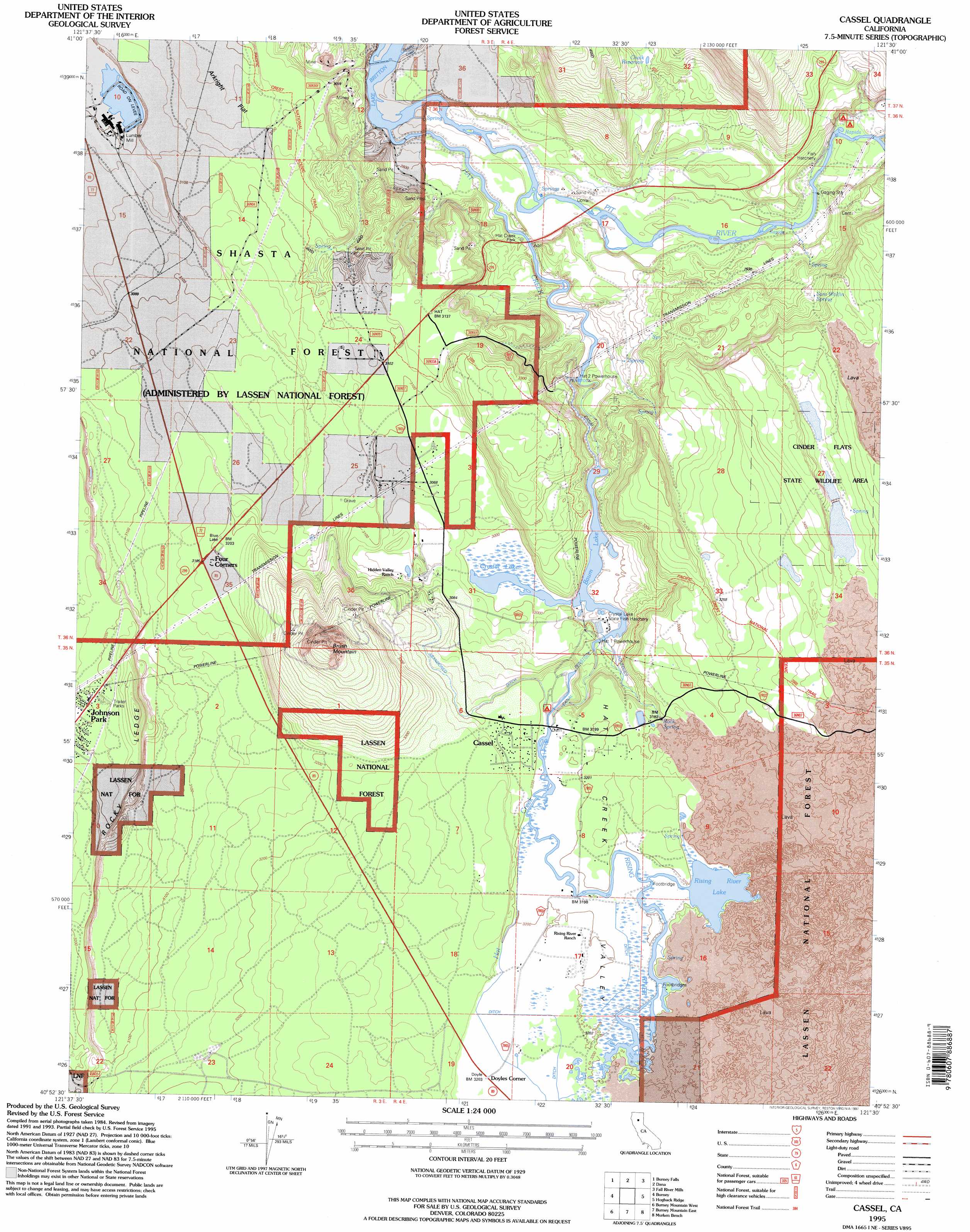
Cassel Topo Map California
To zoom in, hover over the map of Cassel
USGS Topo Quad 40121h5 - 1:24,000 scale
| Topo Map Name: | Cassel |
| USGS Topo Quad ID: | 40121h5 |
| Print Size: | ca. 21 1/4" wide x 27" high |
| Southeast Coordinates: | 40.875° N latitude / 121.5° W longitude |
| Map Center Coordinates: | 40.9375° N latitude / 121.5625° W longitude |
| U.S. State: | CA |
| Filename: | o40121h5.jpg |
| Download Map JPG Image: | Cassel topo map 1:24,000 scale |
| Map Type: | Topographic |
| Topo Series: | 7.5´ |
| Map Scale: | 1:24,000 |
| Source of Map Images: | United States Geological Survey (USGS) |
| Alternate Map Versions: |
Cassel CA 1990, updated 1990 Download PDF Buy paper map Cassel CA 1995, updated 1997 Download PDF Buy paper map Cassel CA 2012 Download PDF Buy paper map Cassel CA 2015 Download PDF Buy paper map |
| FStopo: | US Forest Service topo Cassel is available: Download FStopo PDF Download FStopo TIF |
1:24,000 Topo Quads surrounding Cassel
Dead Horse Summit |
Pondosa |
East Of Pondosa |
Timbered Crater |
Day |
Skunk Ridge |
Burney Falls |
Dana |
Fall River Mills |
Pittville |
Chalk Mountain |
Burney |
Cassel |
Hogback Ridge |
Coble Mountain |
Hatchet Mountain Pass |
Burney Mountain West |
Burney Mountain East |
Murken Bench |
Jellico |
Miller Mountain |
Jacks Backbone |
Thousand Lakes Valley |
Old Station |
Swains Hole |
> Back to 40121e1 at 1:100,000 scale
> Back to 40120a1 at 1:250,000 scale
> Back to U.S. Topo Maps home
Cassel topo map: Gazetteer
Cassel: Benches
Rocky Ledge elevation 948m 3110′Cassel: Dams
Hat Creek Number 2 Diversion 97-109 Dam elevation 912m 2992′Cassel: Flats
Arkright Flat elevation 919m 3015′Cassel: Lakes
Baum Lake elevation 907m 2975′Crystal Lake elevation 912m 2992′
Lake Britton elevation 836m 2742′
Rising River Lake elevation 974m 3195′
Cassel: Mines
Braden Sand Pit elevation 931m 3054′Cassel: Parks
Cinder Flats State Wildlife Area elevation 1047m 3435′Hat Creek Park elevation 1009m 3310′
Cassel: Populated Places
Cassel elevation 973m 3192′Doyles Corner elevation 980m 3215′
Four Corners elevation 971m 3185′
Cassel: Post Offices
Castle Post Office elevation 971m 3185′Cassel: Reservoirs
Chalk Reservoir elevation 931m 3054′Cassel: Springs
Rock Spring elevation 974m 3195′Sam Wolfin Spring elevation 953m 3126′
Cassel: Streams
Hat Creek elevation 834m 2736′Rising River elevation 972m 3188′
Soldier Creek elevation 844m 2769′
Cassel: Summits
Brush Mountain elevation 1141m 3743′Cassel: Valleys
Hat Creek Valley elevation 851m 2791′Cassel digital topo map on disk
Buy this Cassel topo map showing relief, roads, GPS coordinates and other geographical features, as a high-resolution digital map file on DVD: