Chalk Mountain Topo Map California
To zoom in, hover over the map of Chalk Mountain
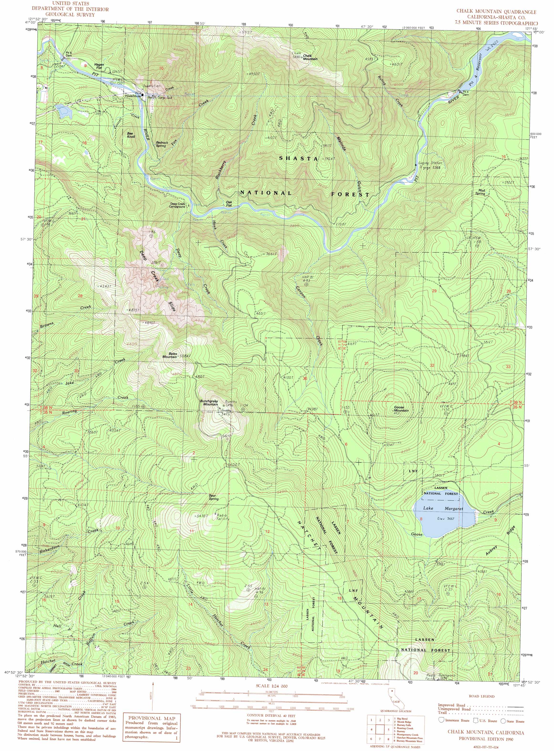
USGS Topo Quad 40121h7 - 1:24,000 scale
| Topo Map Name: | Chalk Mountain |
| USGS Topo Quad ID: | 40121h7 |
| Print Size: | ca. 21 1/4" wide x 27" high |
| Southeast Coordinates: | 40.875° N latitude / 121.75° W longitude |
| Map Center Coordinates: | 40.9375° N latitude / 121.8125° W longitude |
| U.S. State: | CA |
| Filename: | o40121h7.jpg |
| Download Map JPG Image: | Chalk Mountain topo map 1:24,000 scale |
| Map Type: | Topographic |
| Topo Series: | 7.5´ |
| Map Scale: | 1:24,000 |
| Source of Map Images: | United States Geological Survey (USGS) |
| Alternate Map Versions: |
Chalk Mountain CA 1990, updated 1990 Download PDF Buy paper map Chalk Mountain CA 1998, updated 2003 Download PDF Buy paper map Chalk Mountain CA 2012 Download PDF Buy paper map Chalk Mountain CA 2015 Download PDF Buy paper map |
| FStopo: | US Forest Service topo Chalk Mountain is available: Download FStopo PDF Download FStopo TIF |
1:24,000 Topo Quads surrounding Chalk Mountain
Lake Mccloud |
Grizzly Peak |
Dead Horse Summit |
Pondosa |
East Of Pondosa |
Shoeinhorse Mountain |
Big Bend |
Skunk Ridge |
Burney Falls |
Dana |
Goose Gap |
Roaring Creek |
Chalk Mountain |
Burney |
Cassel |
Devils Rock |
Montgomery Creek |
Hatchet Mountain Pass |
Burney Mountain West |
Burney Mountain East |
Oak Run |
Whitmore |
Miller Mountain |
Jacks Backbone |
Thousand Lakes Valley |
> Back to 40121e1 at 1:100,000 scale
> Back to 40120a1 at 1:250,000 scale
> Back to U.S. Topo Maps home
Chalk Mountain topo map: Gazetteer
Chalk Mountain: Dams
Haynes Reservoir 2223 Dam elevation 1119m 3671′Pit Five Dam elevation 621m 2037′
Pit Four Dam elevation 733m 2404′
Pit Number 4 97-100 Dam elevation 726m 2381′
Pit Number 5 Diversion 97-107 Dam elevation 640m 2099′
Chalk Mountain: Flats
Hagen Flat elevation 632m 2073′Oak Flat elevation 677m 2221′
Chalk Mountain: Reservoirs
Lake Margaret elevation 1119m 3671′Pit Four Reservoir elevation 726m 2381′
Pit Four Reservoir elevation 733m 2404′
Chalk Mountain: Slopes
Deep Creek Slide elevation 1110m 3641′Chalk Mountain: Springs
Bear Spring elevation 1630m 5347′Bedrock Spring elevation 775m 2542′
Mud Spring elevation 1151m 3776′
Chalk Mountain: Streams
Blackberry Creek elevation 675m 2214′Buffum Creek elevation 1071m 3513′
Cantrell Creek elevation 625m 2050′
Canyon Creek elevation 699m 2293′
Deep Creek elevation 658m 2158′
Fox Creek elevation 663m 2175′
Hawk Creek elevation 671m 2201′
Ruling Creek elevation 721m 2365′
Screwdriver Creek elevation 740m 2427′
Swift Creek elevation 640m 2099′
Chalk Mountain: Summits
Bales Mountain elevation 1543m 5062′Bee Knoll elevation 801m 2627′
Bunchgrass Mountain elevation 1664m 5459′
Chalk Mountain elevation 1786m 5859′
Goose Mountain elevation 1498m 4914′
Hatchet Mountain elevation 1662m 5452′
Chalk Mountain: Valleys
Malinda Gulch elevation 740m 2427′Chalk Mountain digital topo map on disk
Buy this Chalk Mountain topo map showing relief, roads, GPS coordinates and other geographical features, as a high-resolution digital map file on DVD: