Redding Topo Map California
To zoom in, hover over the map of Redding
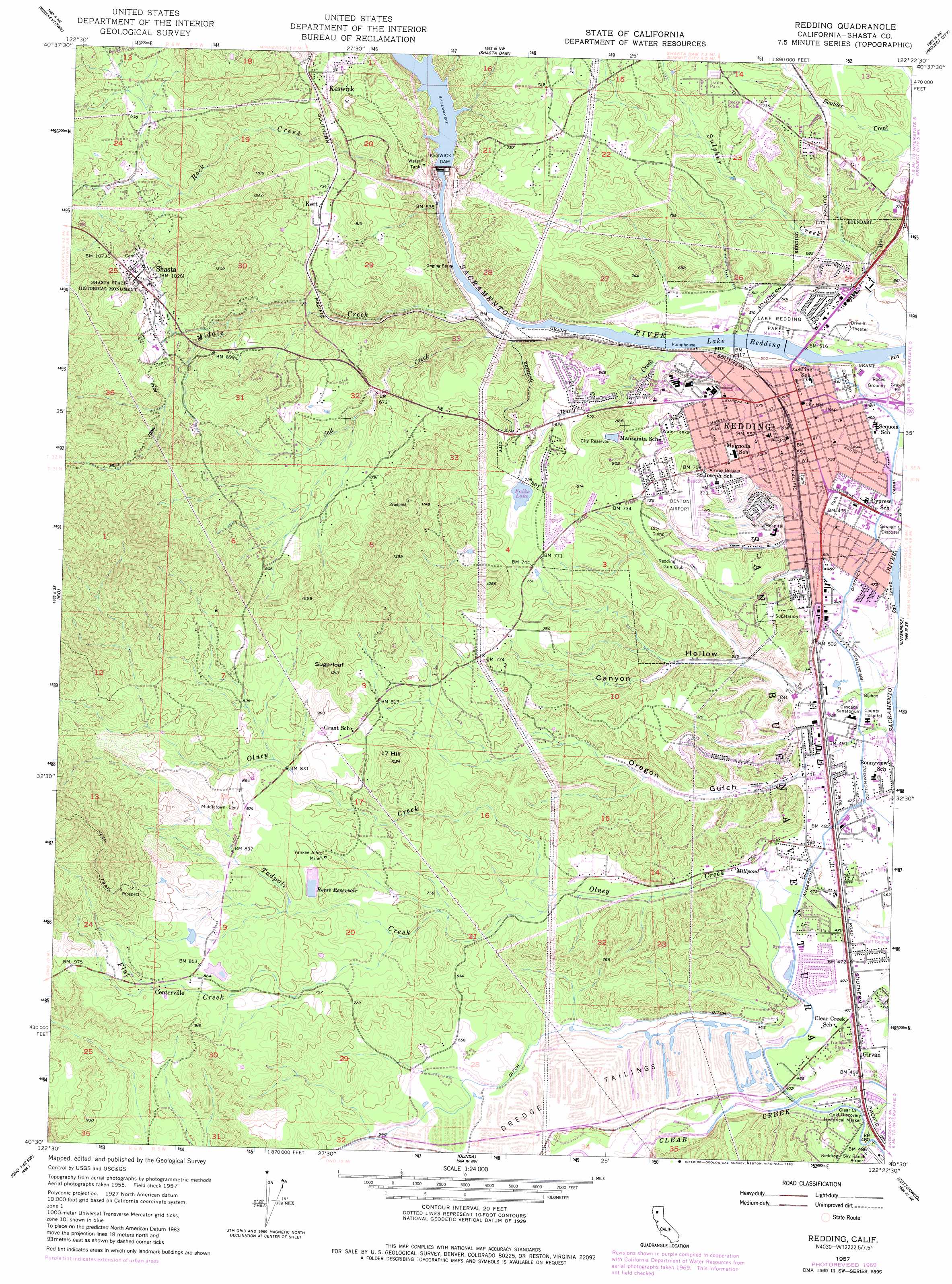
USGS Topo Quad 40122e4 - 1:24,000 scale
| Topo Map Name: | Redding |
| USGS Topo Quad ID: | 40122e4 |
| Print Size: | ca. 21 1/4" wide x 27" high |
| Southeast Coordinates: | 40.5° N latitude / 122.375° W longitude |
| Map Center Coordinates: | 40.5625° N latitude / 122.4375° W longitude |
| U.S. State: | CA |
| Filename: | o40122e4.jpg |
| Download Map JPG Image: | Redding topo map 1:24,000 scale |
| Map Type: | Topographic |
| Topo Series: | 7.5´ |
| Map Scale: | 1:24,000 |
| Source of Map Images: | United States Geological Survey (USGS) |
| Alternate Map Versions: |
Redding CA 1957, updated 1958 Download PDF Buy paper map Redding CA 1957, updated 1970 Download PDF Buy paper map Redding CA 1957, updated 1980 Download PDF Buy paper map Redding CA 1957, updated 1982 Download PDF Buy paper map Redding CA 2012 Download PDF Buy paper map Redding CA 2015 Download PDF Buy paper map |
1:24,000 Topo Quads surrounding Redding
Papoose Creek |
Schell Mountain |
Bohemotash Mountain |
O'Brien |
Minnesota Mountain |
French Gulch |
Whiskeytown |
Shasta Dam |
Project City |
Bella Vista |
Shasta Bally |
Igo |
Redding |
Enterprise |
Palo Cedro |
Ono |
Olinda |
Cottonwood |
Balls Ferry |
|
Rosewood |
Mitchell Gulch |
Hooker |
Bend |
> Back to 40122e1 at 1:100,000 scale
> Back to 40122a1 at 1:250,000 scale
> Back to U.S. Topo Maps home
Redding topo map: Gazetteer
Redding: Airports
Benton Field elevation 222m 728′Mercy Medical Center Heliport elevation 204m 669′
Redding: Dams
Anderson-Cottonwood Diversion 51-000 Dam elevation 147m 482′George Reese Reservoir 225 Dam elevation 232m 761′
James Montgomery 1220 Dam elevation 257m 843′
Keswick Dam elevation 173m 567′
Redding: Mines
Alice Consolidated Mine elevation 257m 843′Black Diamond Mine elevation 254m 833′
Black Spider Mine elevation 272m 892′
Blue Bird Placer Mine elevation 169m 554′
Blue Gravel Mine elevation 193m 633′
Bracket Mine elevation 270m 885′
Buena Vista Mine elevation 270m 885′
Bunker Hill Mine elevation 175m 574′
Carlson and Sandburg Mine elevation 183m 600′
Centerville Hydraulic Pits elevation 214m 702′
Clear Creek Hydraulic Pits elevation 182m 597′
Compton Mine elevation 247m 810′
Corrine Mine elevation 208m 682′
Crownpoint Mine elevation 377m 1236′
Del Oro Mine elevation 223m 731′
Dixon and Cooper Mine elevation 227m 744′
Eureka Tellurium Mine elevation 203m 666′
Gold Leaf Mine elevation 293m 961′
Golden Chariot Mine elevation 330m 1082′
Hope So Mine elevation 225m 738′
Horsetown Placer Mining Area elevation 214m 702′
Hummingbird Mine elevation 206m 675′
Jefferson Mine elevation 186m 610′
Jensen Mine elevation 423m 1387′
Jubilee Mine elevation 329m 1079′
Keswick Hydraulic Pits elevation 236m 774′
Lechner Mine elevation 261m 856′
Manzanita Mine elevation 167m 547′
Midnight Mine elevation 359m 1177′
Mountain Top Mine elevation 214m 702′
Old Spanish Mine elevation 298m 977′
Oro Grande Mine elevation 239m 784′
Rattlesnake Mine elevation 354m 1161′
Sacramento Pliocene Mine elevation 192m 629′
Saddle Pocket Mine elevation 293m 961′
Salee Mine elevation 289m 948′
Salt Creek Mine elevation 203m 666′
Sholes Placer Mine elevation 175m 574′
Silver King Mine elevation 247m 810′
Sugarloaf Mine elevation 261m 856′
Three R Mine elevation 249m 816′
West Point Mine elevation 372m 1220′
White Girl Mine elevation 239m 784′
White King Placer Mine elevation 228m 748′
Winchester Placer Mine elevation 195m 639′
Yankee John Mine elevation 247m 810′
Redding: Parks
Clear Creek Gold Discovery Historical Marker elevation 140m 459′Lake Redding Park elevation 150m 492′
Shasta State Historic Park elevation 376m 1233′
Woods Memorial Park elevation 202m 662′
Redding: Populated Places
Centerville elevation 264m 866′Clear Creek Mobile Home Park elevation 142m 465′
Girvan elevation 139m 456′
Hogtown (historical) elevation 331m 1085′
Keswick elevation 226m 741′
Keswick Dam Trailer Park elevation 226m 741′
Kett elevation 224m 734′
Los Robles Estates elevation 213m 698′
Middletown (historical) elevation 266m 872′
Moose-horn Mobile Home Park elevation 220m 721′
Mountain Shadows Mobile Home Estates elevation 220m 721′
Redding elevation 172m 564′
Redding Oaks Mobile Home Park elevation 144m 472′
Reddingwood Mobile Home Park elevation 152m 498′
Redwoods Mobile Home Community elevation 199m 652′
Riverside Mobile Park elevation 148m 485′
Safari Mobile Home Park elevation 145m 475′
Shady Acres Trailer Park elevation 159m 521′
Shady Oaks Mobile Park elevation 146m 479′
Shasta elevation 319m 1046′
Waugh (historical) elevation 161m 528′
Redding: Post Offices
Redding Post Office elevation 170m 557′Shasta Post Office elevation 304m 997′
Redding: Reservoirs
Falks Lake elevation 220m 721′Keswick Reservoir elevation 173m 567′
Lake Redding elevation 144m 472′
Reese Reservoir elevation 232m 761′
Redding: Streams
Flat Creek elevation 213m 698′Jenny Creek elevation 150m 492′
Middle Creek elevation 150m 492′
Rock Creek elevation 150m 492′
Salt Creek elevation 150m 492′
Sulphur Creek elevation 147m 482′
Tadpole Creek elevation 164m 538′
Redding: Summits
Seventeen Hill elevation 313m 1026′Sugarloaf elevation 363m 1190′
Redding: Valleys
Canyon Hollow elevation 153m 501′Oregon Gulch elevation 150m 492′
Redding digital topo map on disk
Buy this Redding topo map showing relief, roads, GPS coordinates and other geographical features, as a high-resolution digital map file on DVD: