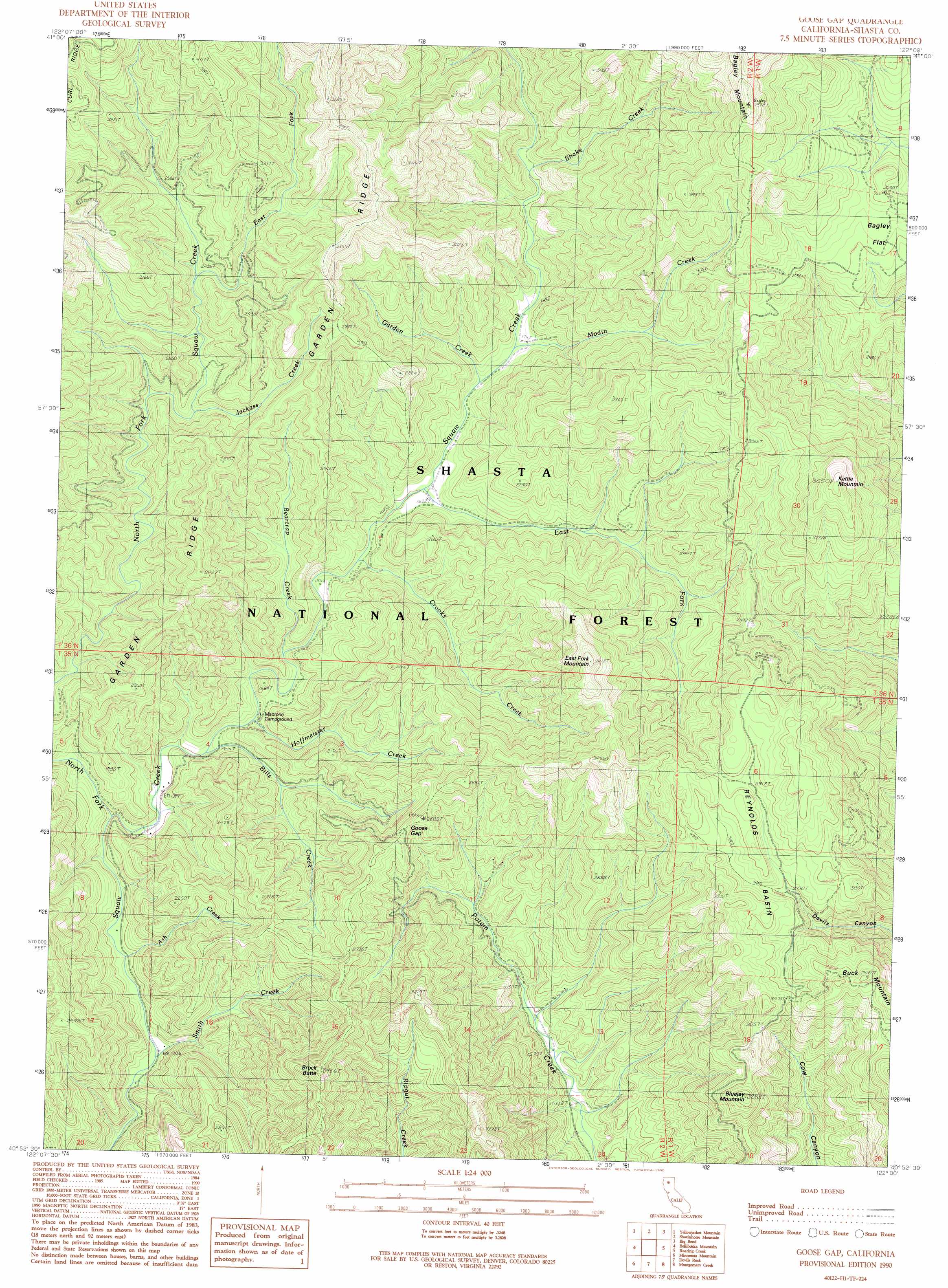
Goose Gap Topo Map California
To zoom in, hover over the map of Goose Gap
USGS Topo Quad 40122h1 - 1:24,000 scale
| Topo Map Name: | Goose Gap |
| USGS Topo Quad ID: | 40122h1 |
| Print Size: | ca. 21 1/4" wide x 27" high |
| Southeast Coordinates: | 40.875° N latitude / 122° W longitude |
| Map Center Coordinates: | 40.9375° N latitude / 122.0625° W longitude |
| U.S. State: | CA |
| Filename: | o40122h1.jpg |
| Download Map JPG Image: | Goose Gap topo map 1:24,000 scale |
| Map Type: | Topographic |
| Topo Series: | 7.5´ |
| Map Scale: | 1:24,000 |
| Source of Map Images: | United States Geological Survey (USGS) |
| Alternate Map Versions: |
Goose Gap CA 1990, updated 1990 Download PDF Buy paper map Goose Gap CA 1998, updated 2003 Download PDF Buy paper map Goose Gap CA 2012 Download PDF Buy paper map Goose Gap CA 2015 Download PDF Buy paper map |
| FStopo: | US Forest Service topo Goose Gap is available: Download FStopo PDF Download FStopo TIF |
1:24,000 Topo Quads surrounding Goose Gap
Dunsmuir |
Girard Ridge |
Lake Mccloud |
Grizzly Peak |
Dead Horse Summit |
Tombstone Mountain |
Yellowjacket Mountain |
Shoeinhorse Mountain |
Big Bend |
Skunk Ridge |
Hanland Peak |
Bollibokka Mountain |
Goose Gap |
Roaring Creek |
Chalk Mountain |
O'Brien |
Minnesota Mountain |
Devils Rock |
Montgomery Creek |
Hatchet Mountain Pass |
Project City |
Bella Vista |
Oak Run |
Whitmore |
Miller Mountain |
> Back to 40122e1 at 1:100,000 scale
> Back to 40122a1 at 1:250,000 scale
> Back to U.S. Topo Maps home
Goose Gap topo map: Gazetteer
Goose Gap: Basins
Reynolds Basin elevation 933m 3061′Goose Gap: Flats
Bagley Flat elevation 840m 2755′Goose Gap: Gaps
Goose Gap elevation 752m 2467′Goose Gap: Populated Places
Kelly (historical) elevation 468m 1535′Goose Gap: Streams
Ash Creek elevation 405m 1328′Beartrap Creek elevation 454m 1489′
Bills Creek elevation 435m 1427′
Crooks Creek elevation 468m 1535′
East Fork North Fork Squaw Creek elevation 709m 2326′
East Fork Squaw Creek elevation 492m 1614′
Garden Creek elevation 510m 1673′
Hoffmeister Creek elevation 448m 1469′
Jackass Creek elevation 665m 2181′
Modin Creek elevation 521m 1709′
North Fork Squaw Creek elevation 413m 1354′
Shake Creek elevation 557m 1827′
Smith Creek elevation 396m 1299′
Goose Gap: Summits
Bagley Mountain elevation 1331m 4366′Bluejay Mountain elevation 1000m 3280′
Brock Butte elevation 1049m 3441′
Buck Mountain elevation 1037m 3402′
East Fork Mountain elevation 1039m 3408′
Kettle Mountain elevation 1104m 3622′
Goose Gap: Valleys
Timber Canyon elevation 442m 1450′Goose Gap digital topo map on disk
Buy this Goose Gap topo map showing relief, roads, GPS coordinates and other geographical features, as a high-resolution digital map file on DVD: