Fort Seward Topo Map California
To zoom in, hover over the map of Fort Seward
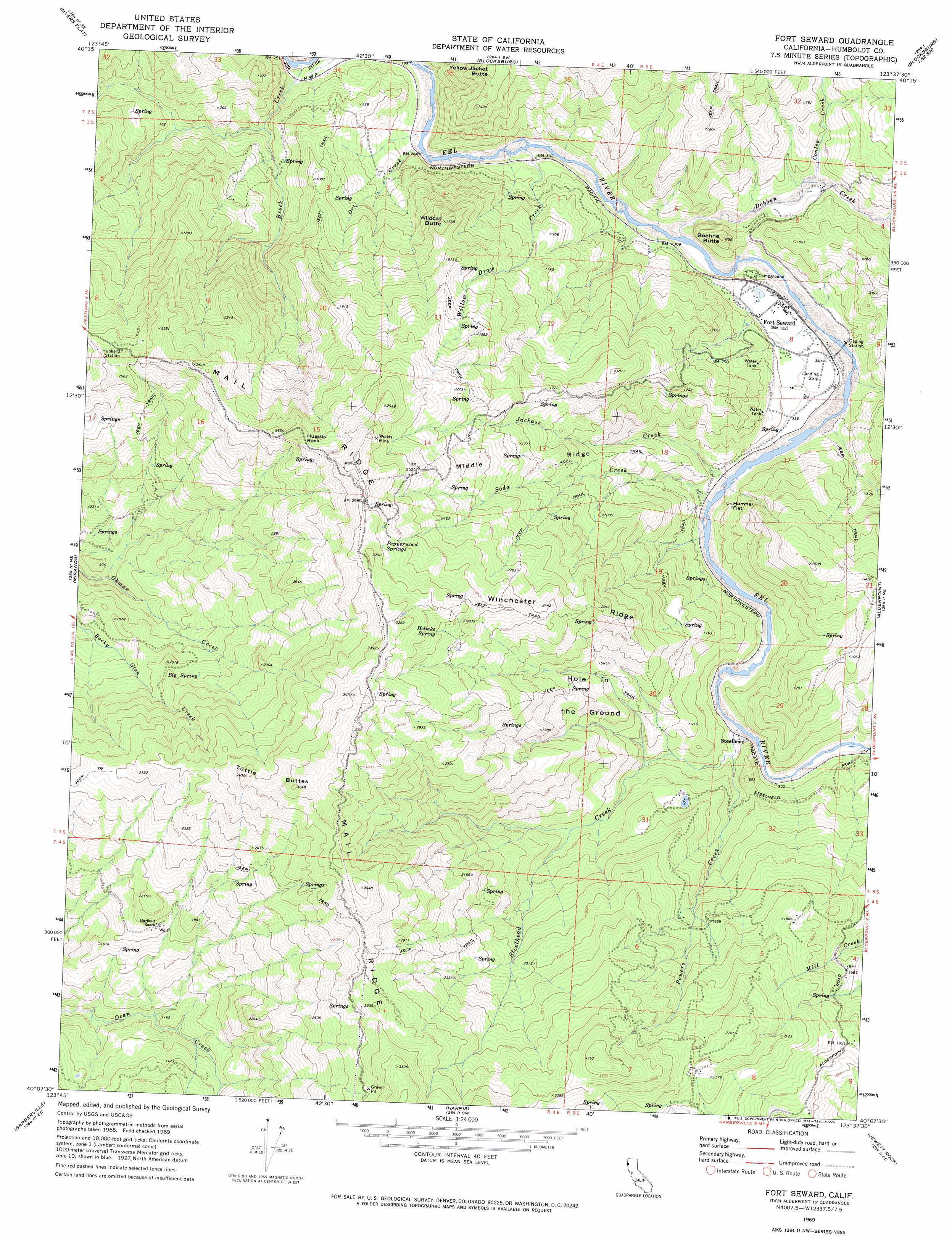
USGS Topo Quad 40123b6 - 1:24,000 scale
| Topo Map Name: | Fort Seward |
| USGS Topo Quad ID: | 40123b6 |
| Print Size: | ca. 21 1/4" wide x 27" high |
| Southeast Coordinates: | 40.125° N latitude / 123.625° W longitude |
| Map Center Coordinates: | 40.1875° N latitude / 123.6875° W longitude |
| U.S. State: | CA |
| Filename: | o40123b6.jpg |
| Download Map JPG Image: | Fort Seward topo map 1:24,000 scale |
| Map Type: | Topographic |
| Topo Series: | 7.5´ |
| Map Scale: | 1:24,000 |
| Source of Map Images: | United States Geological Survey (USGS) |
| Alternate Map Versions: |
Fort Seward CA 1969, updated 1974 Download PDF Buy paper map Fort Seward CA 1969, updated 1974 Download PDF Buy paper map Fort Seward CA 2012 Download PDF Buy paper map Fort Seward CA 2015 Download PDF Buy paper map |
1:24,000 Topo Quads surrounding Fort Seward
Redcrest |
Bridgeville |
Larabee Valley |
Dinsmore |
Sportshaven |
Weott |
Myers Flat |
Blocksburg |
Black Lassic |
Ruth Lake |
Ettersburg |
Miranda |
Fort Seward |
Alderpoint |
Zenia |
Briceland |
Garberville |
Harris |
Jewett Rock |
Lake Mountain |
Bear Harbor |
Piercy |
Noble Butte |
Bell Springs |
Updegraff Ridge |
> Back to 40123a1 at 1:100,000 scale
> Back to 40122a1 at 1:250,000 scale
> Back to U.S. Topo Maps home
Fort Seward topo map: Gazetteer
Fort Seward: Flats
Hamner Flat elevation 123m 403′Hole in the Ground elevation 482m 1581′
Fort Seward: Mines
Woods Mine elevation 868m 2847′Fort Seward: Pillars
Huestis Rock elevation 830m 2723′Fort Seward: Populated Places
Brock Creek (historical) elevation 85m 278′Fort Seward elevation 100m 328′
Steelhead elevation 103m 337′
Fort Seward: Ridges
Middle Ridge elevation 543m 1781′Winchester Ridge elevation 734m 2408′
Fort Seward: Springs
Big Spring elevation 544m 1784′Helmke Spring elevation 853m 2798′
Pepperwood Springs elevation 902m 2959′
Fort Seward: Streams
Brock Creek elevation 61m 200′Conley Creek elevation 83m 272′
Dobbyn Creek elevation 71m 232′
Jackass Creek elevation 74m 242′
Ort Creek elevation 65m 213′
Powers Creek elevation 108m 354′
Soda Creek elevation 80m 262′
Steelhead Creek elevation 74m 242′
Willow Draw Creek elevation 72m 236′
Fort Seward: Summits
Boehne Butte elevation 250m 820′Tuttle Buttes elevation 1095m 3592′
Wildcat Butte elevation 522m 1712′
Yellow Jacket Butte elevation 439m 1440′
Fort Seward: Valleys
Line Gulch elevation 109m 357′Fort Seward digital topo map on disk
Buy this Fort Seward topo map showing relief, roads, GPS coordinates and other geographical features, as a high-resolution digital map file on DVD: