Black Lassic Topo Map California
To zoom in, hover over the map of Black Lassic
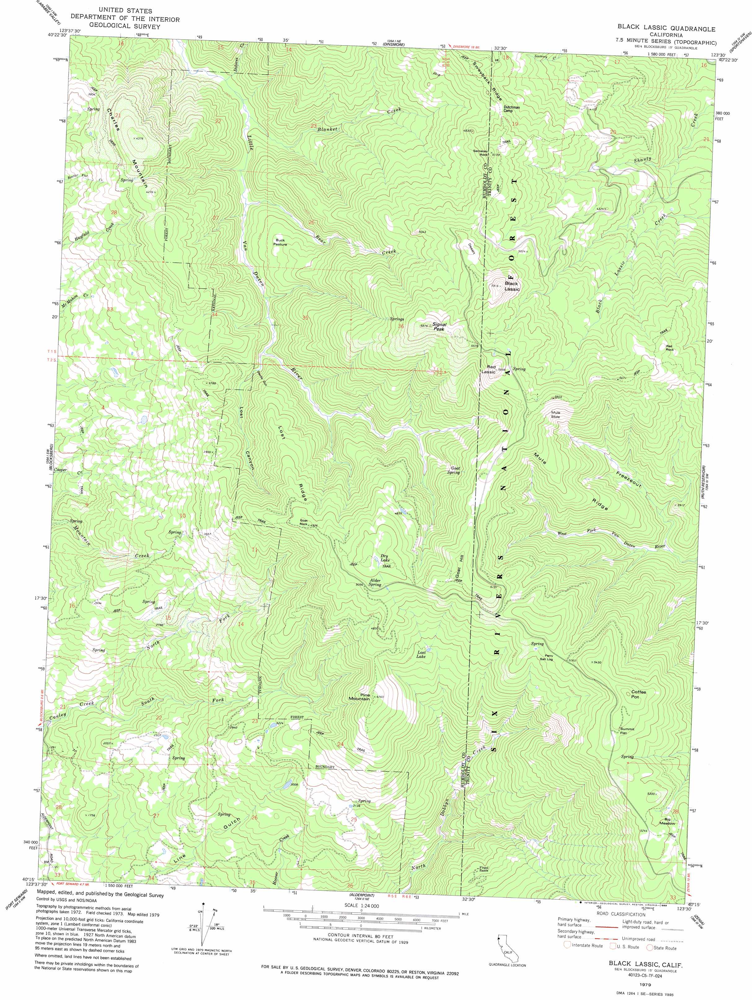
USGS Topo Quad 40123c5 - 1:24,000 scale
| Topo Map Name: | Black Lassic |
| USGS Topo Quad ID: | 40123c5 |
| Print Size: | ca. 21 1/4" wide x 27" high |
| Southeast Coordinates: | 40.25° N latitude / 123.5° W longitude |
| Map Center Coordinates: | 40.3125° N latitude / 123.5625° W longitude |
| U.S. State: | CA |
| Filename: | o40123c5.jpg |
| Download Map JPG Image: | Black Lassic topo map 1:24,000 scale |
| Map Type: | Topographic |
| Topo Series: | 7.5´ |
| Map Scale: | 1:24,000 |
| Source of Map Images: | United States Geological Survey (USGS) |
| Alternate Map Versions: |
Black Lassic CA 1979, updated 1979 Download PDF Buy paper map Black Lassic CA 1979, updated 1979 Download PDF Buy paper map Black Lassic CA 1979, updated 1988 Download PDF Buy paper map Black Lassic CA 1997, updated 2001 Download PDF Buy paper map Black Lassic CA 2012 Download PDF Buy paper map Black Lassic CA 2015 Download PDF Buy paper map |
| FStopo: | US Forest Service topo Black Lassic is available: Download FStopo PDF Download FStopo TIF |
1:24,000 Topo Quads surrounding Black Lassic
Yager Junction |
Showers Mountain |
Blake Mountain |
Hyampom |
Halfway Ridge |
Bridgeville |
Larabee Valley |
Dinsmore |
Sportshaven |
Naufus Creek |
Myers Flat |
Blocksburg |
Black Lassic |
Ruth Lake |
Forest Glen |
Miranda |
Fort Seward |
Alderpoint |
Zenia |
Shannon Butte |
Garberville |
Harris |
Jewett Rock |
Lake Mountain |
Long Ridge |
> Back to 40123a1 at 1:100,000 scale
> Back to 40122a1 at 1:250,000 scale
> Back to U.S. Topo Maps home
Black Lassic topo map: Gazetteer
Black Lassic: Flats
Buck Pasture elevation 1041m 3415′Perry Salt Log elevation 1529m 5016′
Summit Flat elevation 1648m 5406′
Black Lassic: Guts
Devils Gut elevation 1066m 3497′Black Lassic: Lakes
Dry Lake elevation 1606m 5269′Lost Lake elevation 1316m 4317′
Black Lassic: Pillars
Goat Rock elevation 1493m 4898′Red Rock elevation 1565m 5134′
Senteney Rock elevation 1569m 5147′
Black Lassic: Ridges
Lost Ridge elevation 1368m 4488′Mule Ridge elevation 1662m 5452′
Black Lassic: Slopes
Mule Slide elevation 1576m 5170′Black Lassic: Springs
Alder Spring elevation 1563m 5127′Big Meadow Springs elevation 1582m 5190′
Big Meadows Springs elevation 1582m 5190′
Goat Spring elevation 1482m 4862′
Black Lassic: Streams
Bear Creek elevation 875m 2870′Blanket Creek elevation 847m 2778′
Dolores Creek elevation 841m 2759′
North Fork Conley Creek elevation 465m 1525′
South Fork Conley Creek elevation 465m 1525′
Black Lassic: Summits
Black Lassic elevation 1791m 5875′Charles Mountain elevation 1328m 4356′
Coffee Pot elevation 1711m 5613′
Goat Hill elevation 1662m 5452′
Pine Mountain elevation 1443m 4734′
Red Lassic elevation 1785m 5856′
Signal Peak elevation 1783m 5849′
Black Lassic: Valleys
Freezeout elevation 1087m 3566′Lost Canyon elevation 953m 3126′
Black Lassic digital topo map on disk
Buy this Black Lassic topo map showing relief, roads, GPS coordinates and other geographical features, as a high-resolution digital map file on DVD: