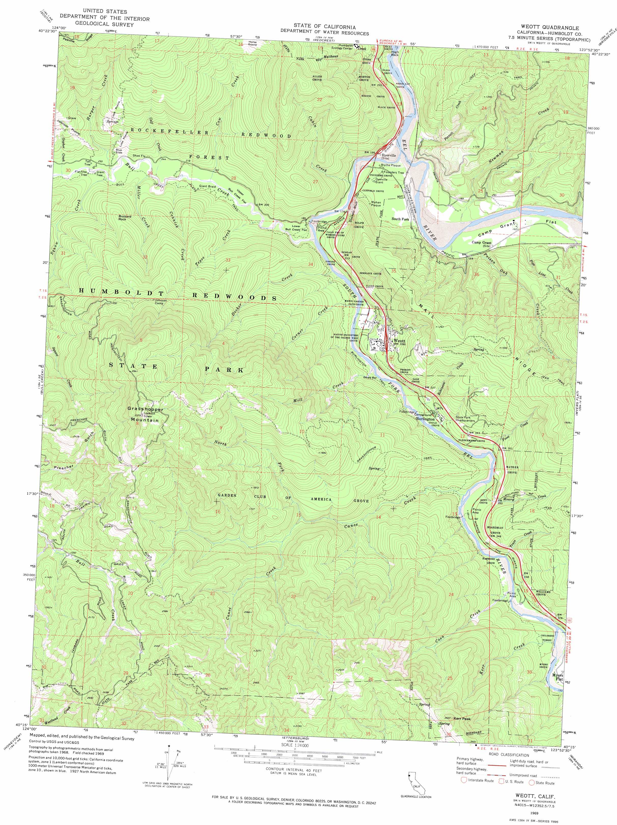
Weott Topo Map California
To zoom in, hover over the map of Weott
USGS Topo Quad 40123c8 - 1:24,000 scale
| Topo Map Name: | Weott |
| USGS Topo Quad ID: | 40123c8 |
| Print Size: | ca. 21 1/4" wide x 27" high |
| Southeast Coordinates: | 40.25° N latitude / 123.875° W longitude |
| Map Center Coordinates: | 40.3125° N latitude / 123.9375° W longitude |
| U.S. State: | CA |
| Filename: | o40123c8.jpg |
| Download Map JPG Image: | Weott topo map 1:24,000 scale |
| Map Type: | Topographic |
| Topo Series: | 7.5´ |
| Map Scale: | 1:24,000 |
| Source of Map Images: | United States Geological Survey (USGS) |
| Alternate Map Versions: |
Weott CA 1969, updated 1974 Download PDF Buy paper map Weott CA 1969, updated 1974 Download PDF Buy paper map Weott CA 2012 Download PDF Buy paper map Weott CA 2015 Download PDF Buy paper map |
1:24,000 Topo Quads surrounding Weott
Fortuna |
Hydesville |
Owl Creek |
Yager Junction |
Showers Mountain |
Taylor Peak |
Scotia |
Redcrest |
Bridgeville |
Larabee Valley |
Buckeye Mountain |
Bull Creek |
Weott |
Myers Flat |
Blocksburg |
Shubrick Peak |
Honeydew |
Ettersburg |
Miranda |
Fort Seward |
Shelter Cove |
Briceland |
Garberville |
Harris |
> Back to 40123a1 at 1:100,000 scale
> Back to 40122a1 at 1:250,000 scale
> Back to U.S. Topo Maps home
Weott topo map: Gazetteer
Weott: Areas
Look Prairie elevation 310m 1017′Native Daughters of the Golden West Grove elevation 60m 196′
Weott: Bars
Dyerville Bar elevation 39m 127′Gould Bar elevation 37m 121′
Leatherwood Bar elevation 37m 121′
Weott: Cliffs
Duckett Bluff elevation 99m 324′Weott: Flats
Bull Creek Flat elevation 64m 209′Camp Grant Flat elevation 43m 141′
Lower Bull Creek Flat elevation 50m 164′
Upper Bull Creek Flat elevation 53m 173′
Weott: Forests
Childrens Forest elevation 71m 232′Rockefeller Redwood Forest elevation 181m 593′
Weott: Parks
Humboldt Redwoods State Park elevation 461m 1512′Weott: Pillars
Buzzard Rock elevation 235m 770′High Rock elevation 67m 219′
Weott: Populated Places
Burlington elevation 54m 177′Weott elevation 87m 285′
Weott: Slopes
Blue Slide elevation 107m 351′Weott: Streams
Cabin Creek elevation 44m 144′Calf Creek elevation 62m 203′
Canoe Creek elevation 40m 131′
Connick Creek elevation 60m 196′
Coon Creek elevation 42m 137′
Corner Creek elevation 46m 150′
Cow Creek elevation 54m 177′
Decker Creek elevation 52m 170′
Feese Creek elevation 46m 150′
Gopher Creek elevation 80m 262′
Harper Creek elevation 70m 229′
Kerr Creek elevation 44m 144′
Matthews Creek elevation 66m 216′
Mill Creek elevation 40m 131′
Miller Creek elevation 62m 203′
Mowry Creek elevation 40m 131′
Newman Creek elevation 36m 118′
North Fork Canoe Creek elevation 241m 790′
Perrott Creek elevation 39m 127′
Pipe Line Creek elevation 48m 157′
Poison Oak Creek elevation 35m 114′
Robinson Creek elevation 38m 124′
South Fork Eel River elevation 33m 108′
Squaw Creek elevation 71m 232′
Tepee Creek elevation 54m 177′
Truss Creek elevation 46m 150′
Weott: Summits
Grasshopper Mountain elevation 1028m 3372′Kerr Peak elevation 787m 2582′
Weott: Trails
Allens Trail elevation 191m 626′Bull Creek Flats Trail elevation 70m 229′
Burlington Trail elevation 62m 203′
Burlington-Weott Trail elevation 77m 252′
Canoe Creek Loop Trail elevation 71m 232′
Childrens Forest Trail elevation 79m 259′
Founders Grove Nature Trail elevation 55m 180′
Grasshopper Trail elevation 271m 889′
Rockefeller Loop Trail elevation 48m 157′
Williams Grove Trail elevation 58m 190′
Weott: Woods
Allen Grove elevation 571m 1873′Arbor Day Grove elevation 56m 183′
Black Grove elevation 233m 764′
Boardman Grove elevation 137m 449′
California Federation of Womens Clubs Grove elevation 50m 164′
Canfield Grove elevation 60m 196′
Clark Grove elevation 157m 515′
Dimond Grove elevation 75m 246′
Dungan Grove elevation 151m 495′
Fleischmann Grove elevation 64m 209′
Founders Grove elevation 50m 164′
Garden Club of America Grove elevation 285m 935′
Gould Grove elevation 41m 134′
Haas Grove elevation 104m 341′
Hammond Grove elevation 55m 180′
Kent Grove elevation 65m 213′
Krauss Grove elevation 284m 931′
Luke Prairie elevation 169m 554′
Marin Garden Club Grove elevation 36m 118′
Mather Grove elevation 105m 344′
Morton Grove elevation 285m 935′
Myers Grove elevation 44m 144′
Olson Grove elevation 66m 216′
Perrott Grove elevation 100m 328′
Ritzer Grove elevation 214m 702′
Rolph Grove elevation 150m 492′
Sage Grove elevation 106m 347′
Sherlock Grove elevation 161m 528′
Williams Grove elevation 98m 321′
Weott digital topo map on disk
Buy this Weott topo map showing relief, roads, GPS coordinates and other geographical features, as a high-resolution digital map file on DVD: