Wildwood Topo Map California
To zoom in, hover over the map of Wildwood
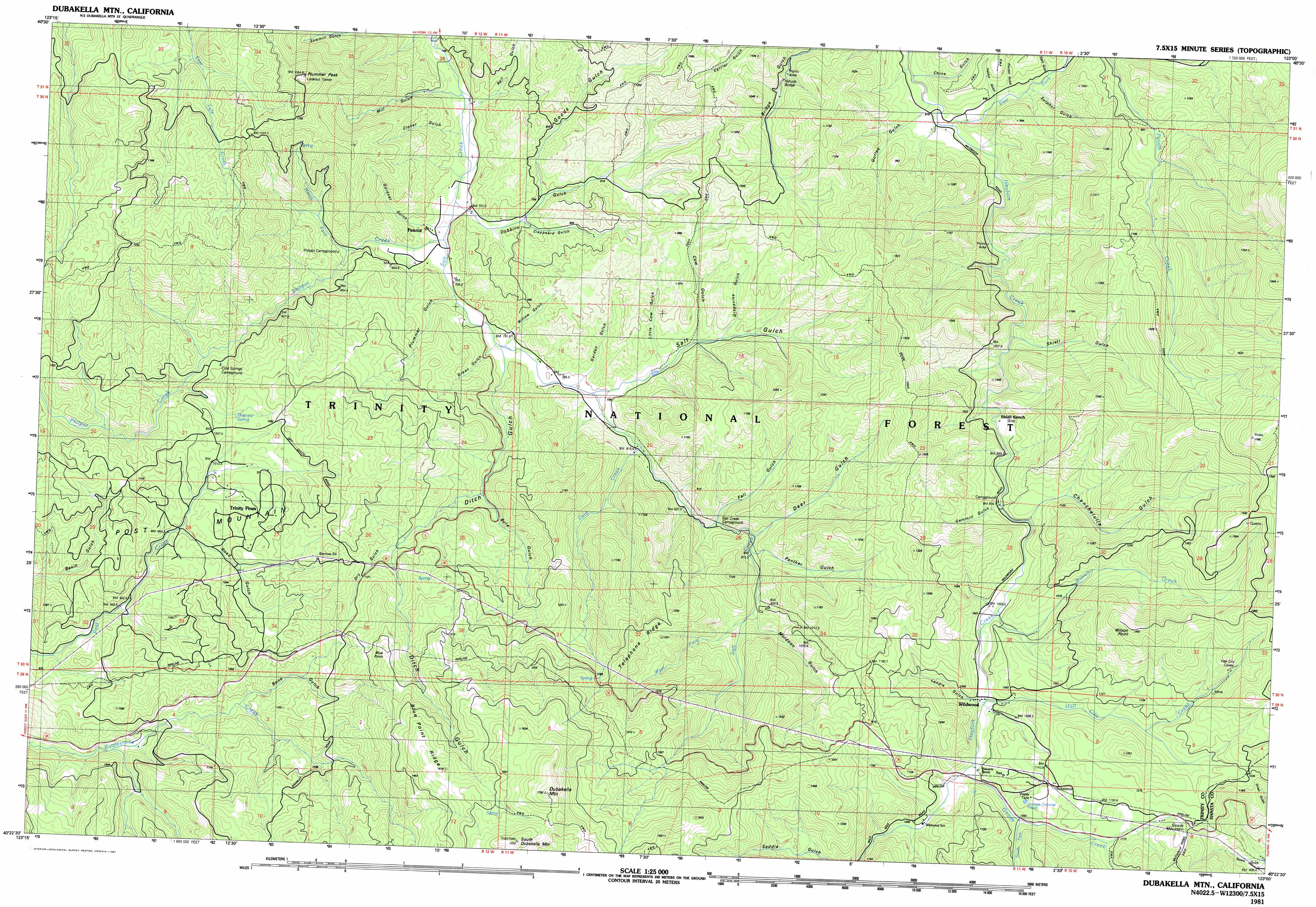
USGS Topo Quad 40123d1 - 1:25,000 scale
| Topo Map Name: | Wildwood |
| USGS Topo Quad ID: | 40123d1 |
| Print Size: | ca. 39" wide x 24" high |
| Southeast Coordinates: | 40.375° N latitude / 123° W longitude |
| Map Center Coordinates: | 40.4375° N latitude / 123.125° W longitude |
| U.S. State: | CA |
| Filename: | k40123d1.jpg |
| Download Map JPG Image: | Wildwood topo map 1:25,000 scale |
| Map Type: | Topographic |
| Topo Series: | 7.5´x15´ |
| Map Scale: | 1:25,000 |
| Source of Map Images: | United States Geological Survey (USGS) |
| Alternate Map Versions: |
Dubakella Mtn CA 1981, updated 1981 Download PDF Buy paper map Dubakella Mtn CA 1981, updated 1981 Download PDF Buy paper map |
| FStopo: | US Forest Service topo Wildwood is available: Download FStopo PDF Download FStopo TIF |
1:24,000 Topo Quads surrounding Wildwood
Big Bar |
Hayfork Bally |
Junction City |
Weaverville |
Lewiston |
Halfway Ridge |
Hayfork |
Hayfork Summit |
Hossimbim Mountain |
Bully Choop Mountain |
Naufus Creek |
Wildwood |
Arbuckle Mountain |
||
Forest Glen |
Pony Buck Peak |
Beegum |
||
Shannon Butte |
Black Rock Mountain |
Tomhead Mountain |
> Back to 40123a1 at 1:100,000 scale
> Back to 40122a1 at 1:250,000 scale
> Back to U.S. Topo Maps home
Wildwood topo map: Gazetteer
Wildwood: Arches
Massacre Natural Bridge elevation 872m 2860′Wildwood: Capes
Wilson Point elevation 1446m 4744′Wildwood: Populated Places
Peanut elevation 784m 2572′Wildwood elevation 1023m 3356′
Wildwood: Ridges
Blue Point Ridge elevation 1601m 5252′Telephone Ridge elevation 1186m 3891′
Wildwood: Springs
Plummer Spring elevation 1132m 3713′Wildwood: Streams
Cold Creek elevation 825m 2706′Fall Creek elevation 860m 2821′
Goods Creek elevation 1026m 3366′
Hall City Creek elevation 1011m 3316′
North Fork Philpot Creek elevation 794m 2604′
Philpot Creek elevation 757m 2483′
South Fork Goods Creek elevation 1055m 3461′
West Fork Salt Creek elevation 948m 3110′
Wilson Creek elevation 996m 3267′
Wildwood: Summits
Dubakella Mountain elevation 1785m 5856′Goods Mountain elevation 1229m 4032′
Plummer Peak elevation 1330m 4363′
Post Mountain elevation 995m 3264′
South Dubakella Mountain elevation 1760m 5774′
Wildwood: Trails
Divide Trail elevation 1278m 4192′Wildwood: Valleys
Bone Gulch elevation 1024m 3359′Bule Gulch elevation 907m 2975′
Chanchelulla Gulch elevation 1023m 3356′
China Gulch elevation 819m 2687′
Clapboard Gulch elevation 782m 2565′
Clover Gulch elevation 756m 2480′
Cow Gulch elevation 859m 2818′
Deer Gulch elevation 913m 2995′
Ditch Gulch elevation 800m 2624′
Dobbins Gulch elevation 780m 2559′
Dry Gulch elevation 1129m 3704′
Fourbit Gulch elevation 843m 2765′
Gant Gulch elevation 845m 2772′
Garden Gulch elevation 807m 2647′
Gardner Gulch elevation 780m 2559′
Gemmill Gulch elevation 983m 3225′
Goods Gulch elevation 817m 2680′
Grapevine Gulch elevation 881m 2890′
Gurley Gulch elevation 822m 2696′
Landis Gulch elevation 1036m 3398′
Little Cow Gulch elevation 853m 2798′
Mill Gulch elevation 756m 2480′
Muldoon Gulch elevation 928m 3044′
Panther Gulch elevation 902m 2959′
Plummer Gulch elevation 794m 2604′
Rail Gulch elevation 767m 2516′
Road Gulch elevation 997m 3270′
Saddle Gulch elevation 1129m 3704′
Salt Gulch elevation 813m 2667′
Shiell Gulch elevation 915m 3001′
Sulphur Gulch elevation 874m 2867′
Twobit Gulch elevation 837m 2746′
Willow Gulch elevation 797m 2614′
Wildwood digital topo map on disk
Buy this Wildwood topo map showing relief, roads, GPS coordinates and other geographical features, as a high-resolution digital map file on DVD: