Hayfork Summit Topo Map California
To zoom in, hover over the map of Hayfork Summit
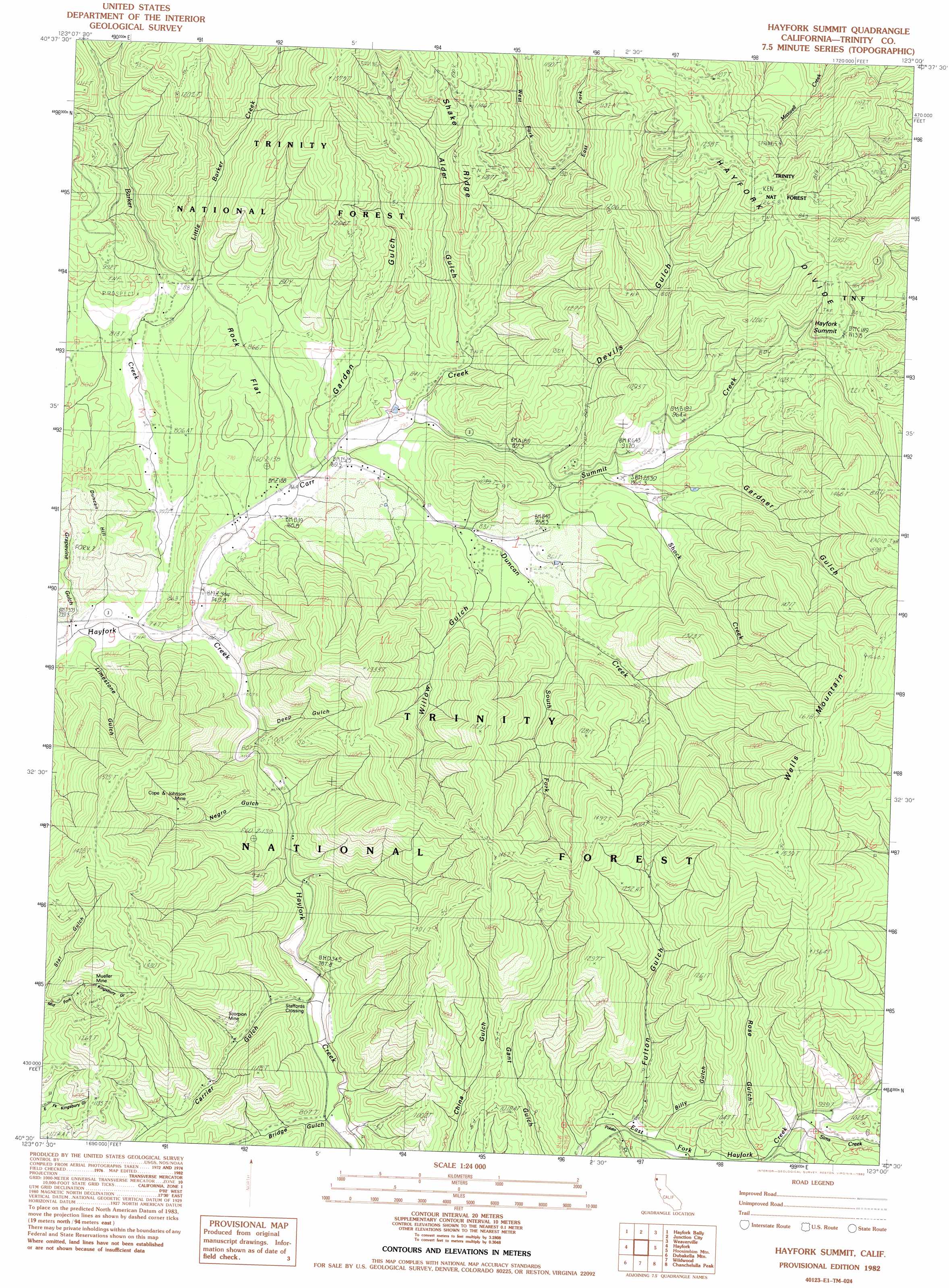
USGS Topo Quad 40123e1 - 1:24,000 scale
| Topo Map Name: | Hayfork Summit |
| USGS Topo Quad ID: | 40123e1 |
| Print Size: | ca. 21 1/4" wide x 27" high |
| Southeast Coordinates: | 40.5° N latitude / 123° W longitude |
| Map Center Coordinates: | 40.5625° N latitude / 123.0625° W longitude |
| U.S. State: | CA |
| Filename: | o40123e1.jpg |
| Download Map JPG Image: | Hayfork Summit topo map 1:24,000 scale |
| Map Type: | Topographic |
| Topo Series: | 7.5´ |
| Map Scale: | 1:24,000 |
| Source of Map Images: | United States Geological Survey (USGS) |
| Alternate Map Versions: |
Hayfork Summit CA 1982, updated 1982 Download PDF Buy paper map Hayfork Summit CA 1998, updated 2003 Download PDF Buy paper map Hayfork Summit CA 2012 Download PDF Buy paper map Hayfork Summit CA 2015 Download PDF Buy paper map |
| FStopo: | US Forest Service topo Hayfork Summit is available: Download FStopo PDF Download FStopo TIF |
1:24,000 Topo Quads surrounding Hayfork Summit
Del Loma |
Helena |
Dedrick |
Rush Creek Lakes |
Trinity Dam |
Big Bar |
Hayfork Bally |
Junction City |
Weaverville |
Lewiston |
Halfway Ridge |
Hayfork |
Hayfork Summit |
Hossimbim Mountain |
Bully Choop Mountain |
Naufus Creek |
Wildwood |
Arbuckle Mountain |
||
Forest Glen |
Pony Buck Peak |
Beegum |
> Back to 40123e1 at 1:100,000 scale
> Back to 40122a1 at 1:250,000 scale
> Back to U.S. Topo Maps home
Hayfork Summit topo map: Gazetteer
Hayfork Summit: Crossings
Staffords Crossing elevation 810m 2657′Hayfork Summit: Flats
Rock Flat elevation 867m 2844′Hayfork Summit: Gaps
Hayfork Summit elevation 1159m 3802′Hayfork Summit: Mines
Cope and Johnson Mine elevation 1030m 3379′Mueller Mine elevation 1122m 3681′
Scorpion Mine elevation 956m 3136′
Hayfork Summit: Ridges
Shake Ridge elevation 1165m 3822′Hayfork Summit: Streams
Barker Creek elevation 740m 2427′Carr Creek elevation 787m 2582′
Duncan Creek elevation 782m 2565′
East Fork Carr Creek elevation 898m 2946′
East Fork Hayfork Creek elevation 809m 2654′
Little Barker Creek elevation 822m 2696′
North Fork East Fork Hayfork Creek elevation 953m 3126′
Potato Creek elevation 863m 2831′
Shock Creek elevation 849m 2785′
Sims Creek elevation 920m 3018′
South Fork Duncan Creek elevation 900m 2952′
Summit Creek elevation 793m 2601′
West Fork Carr Creek elevation 907m 2975′
Hayfork Summit: Summits
Duncan Hill elevation 930m 3051′Wells Mountain elevation 1660m 5446′
Hayfork Summit: Valleys
Alder Gulch elevation 837m 2746′Billy Gulch elevation 914m 2998′
Bridge Gulch elevation 818m 2683′
Carrier Gulch elevation 810m 2657′
Deep Gulch elevation 788m 2585′
Devils Gulch elevation 847m 2778′
Fulton Gulch elevation 882m 2893′
Garden Gulch elevation 788m 2585′
Gardner Gulch elevation 902m 2959′
Grapevine Gulch elevation 776m 2545′
Limestone Gulch elevation 774m 2539′
Negro Gulch elevation 794m 2604′
Ross Gulch elevation 925m 3034′
Willow Gulch elevation 825m 2706′
Hayfork Summit digital topo map on disk
Buy this Hayfork Summit topo map showing relief, roads, GPS coordinates and other geographical features, as a high-resolution digital map file on DVD: