Showers Mountain Topo Map California
To zoom in, hover over the map of Showers Mountain
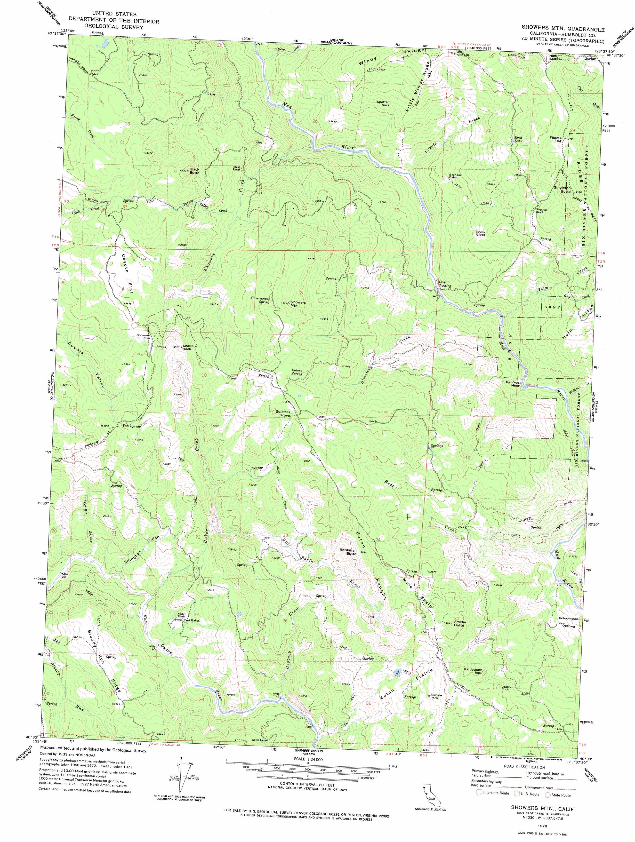
USGS Topo Quad 40123e6 - 1:24,000 scale
| Topo Map Name: | Showers Mountain |
| USGS Topo Quad ID: | 40123e6 |
| Print Size: | ca. 21 1/4" wide x 27" high |
| Southeast Coordinates: | 40.5° N latitude / 123.625° W longitude |
| Map Center Coordinates: | 40.5625° N latitude / 123.6875° W longitude |
| U.S. State: | CA |
| Filename: | o40123e6.jpg |
| Download Map JPG Image: | Showers Mountain topo map 1:24,000 scale |
| Map Type: | Topographic |
| Topo Series: | 7.5´ |
| Map Scale: | 1:24,000 |
| Source of Map Images: | United States Geological Survey (USGS) |
| Alternate Map Versions: |
Showers Mtn CA 1978, updated 1978 Download PDF Buy paper map Showers Mtn CA 1978, updated 1988 Download PDF Buy paper map Showers Mountain CA 1997, updated 2001 Download PDF Buy paper map Showers Mountain CA 2012 Download PDF Buy paper map Showers Mountain CA 2015 Download PDF Buy paper map |
| FStopo: | US Forest Service topo Showers Mountain is available: Download FStopo PDF Download FStopo TIF |
1:24,000 Topo Quads surrounding Showers Mountain
Korbel |
Maple Creek |
Grouse Mountain |
Hennessy Peak |
Ironside Mountain |
Iaqua Buttes |
Mad River Buttes |
Board Camp Mountain |
Sims Mountain |
Hyampom Mountain |
Owl Creek |
Yager Junction |
Showers Mountain |
Blake Mountain |
Hyampom |
Redcrest |
Bridgeville |
Larabee Valley |
Dinsmore |
Sportshaven |
Weott |
Myers Flat |
Blocksburg |
Black Lassic |
Ruth Lake |
> Back to 40123e1 at 1:100,000 scale
> Back to 40122a1 at 1:250,000 scale
> Back to U.S. Topo Maps home
Showers Mountain topo map: Gazetteer
Showers Mountain: Areas
High Salt Ground elevation 1353m 4438′Schoolhouse Opening elevation 744m 2440′
Showers Mountain: Basins
Mule Basin elevation 1044m 3425′Mule Basin elevation 1149m 3769′
Showers Mountain: Bends
Renfroe Hole elevation 608m 1994′Showers Mountain: Crossings
Olsen Crossing elevation 608m 1994′Showers Mountain: Flats
Coyote Flat elevation 1081m 3546′Eaton Prairie elevation 930m 3051′
Filaree Flat elevation 1298m 4258′
Snow Glade elevation 904m 2965′
Showers Mountain: Gaps
Showers Pass elevation 1092m 3582′Showers Mountain: Lakes
Rock Lake elevation 1093m 3585′Showers Mountain: Pillars
Little Pilot Rock elevation 1221m 4005′Lookout Rock elevation 1120m 3674′
Pilot Rock elevation 1347m 4419′
Rattlesnake Rock elevation 1104m 3622′
Showers Rock elevation 1222m 4009′
Spotted Rock elevation 923m 3028′
Suicide Rock elevation 1051m 3448′
Showers Mountain: Ridges
Bloody Run Ridge elevation 711m 2332′Eaton Roughs elevation 1111m 3645′
Little Windy Ridge elevation 1051m 3448′
Pilot Ridge elevation 1278m 4192′
Windy Ridge elevation 1150m 3772′
Showers Mountain: Springs
Government Spring elevation 1240m 4068′Indian Spring elevation 1239m 4064′
Tule Spring elevation 1084m 3556′
Showers Mountain: Streams
Baker Creek elevation 351m 1151′Bear Creek elevation 643m 2109′
Coyote Creek elevation 605m 1984′
Deer Creek elevation 564m 1850′
Guy Creek elevation 775m 2542′
Hogback Creek elevation 445m 1459′
Holm Creek elevation 608m 1994′
Mule Basin Creek elevation 695m 2280′
Olmstead Creek elevation 608m 1994′
Showers Creek elevation 580m 1902′
Spring Valley Creek elevation 886m 2906′
Wildcat Creek elevation 629m 2063′
Showers Mountain: Summits
Amelia Butte elevation 1203m 3946′Black Butte elevation 1254m 4114′
Brinkman Butte elevation 1188m 3897′
Showers Mountain elevation 1347m 4419′
Singleton Butte elevation 1324m 4343′
Showers Mountain: Trails
Pilot Ridge Trail elevation 1282m 4206′Showers Mountain: Valleys
Ellington Gulch elevation 361m 1184′Rough Gulch elevation 346m 1135′
Showers Mountain: Woods
Soldiers Grove elevation 1235m 4051′Showers Mountain digital topo map on disk
Buy this Showers Mountain topo map showing relief, roads, GPS coordinates and other geographical features, as a high-resolution digital map file on DVD: