Korbel Topo Map California
To zoom in, hover over the map of Korbel
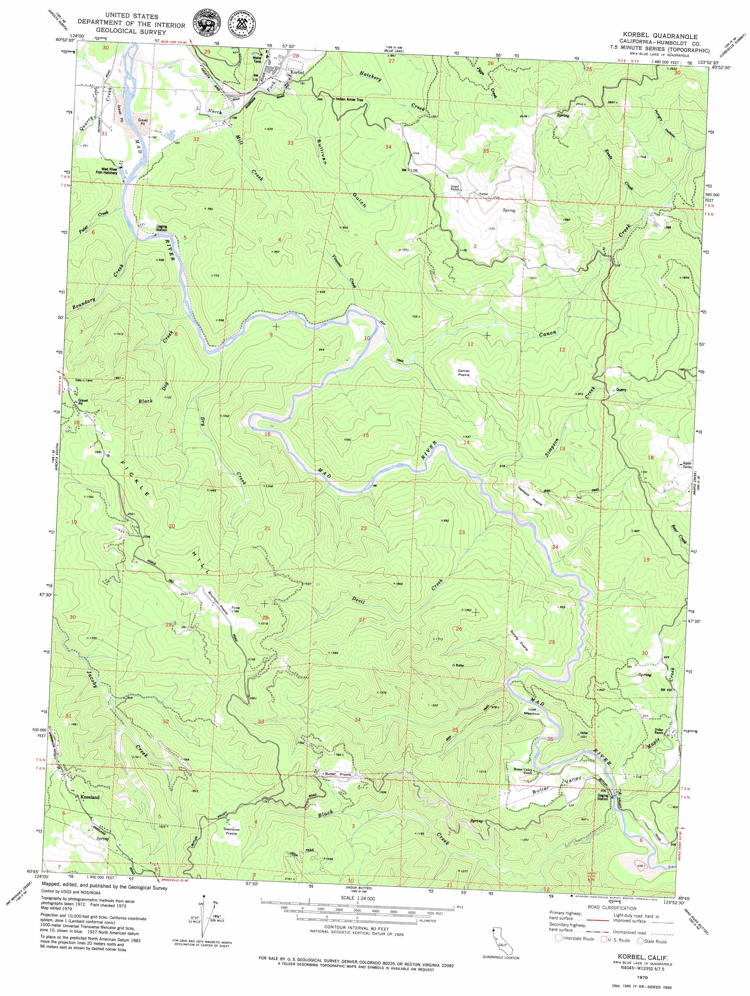
USGS Topo Quad 40123g8 - 1:24,000 scale
| Topo Map Name: | Korbel |
| USGS Topo Quad ID: | 40123g8 |
| Print Size: | ca. 21 1/4" wide x 27" high |
| Southeast Coordinates: | 40.75° N latitude / 123.875° W longitude |
| Map Center Coordinates: | 40.8125° N latitude / 123.9375° W longitude |
| U.S. State: | CA |
| Filename: | o40123g8.jpg |
| Download Map JPG Image: | Korbel topo map 1:24,000 scale |
| Map Type: | Topographic |
| Topo Series: | 7.5´ |
| Map Scale: | 1:24,000 |
| Source of Map Images: | United States Geological Survey (USGS) |
| Alternate Map Versions: |
Korbel CA 1979, updated 1979 Download PDF Buy paper map Korbel CA 2012 Download PDF Buy paper map Korbel CA 2015 Download PDF Buy paper map |
1:24,000 Topo Quads surrounding Korbel
Trinidad |
Crannell |
Panther Creek |
Hupa Mountain |
Hoopa |
Tyee City |
Arcata North |
Blue Lake |
Lord-Ellis Summit |
Willow Creek |
Eureka |
Arcata South |
Korbel |
Maple Creek |
Grouse Mountain |
Fields Landing |
Mcwhinney Creek |
Iaqua Buttes |
Mad River Buttes |
Board Camp Mountain |
Fortuna |
Hydesville |
Owl Creek |
Yager Junction |
Showers Mountain |
> Back to 40123e1 at 1:100,000 scale
> Back to 40122a1 at 1:250,000 scale
> Back to U.S. Topo Maps home
Korbel topo map: Gazetteer
Korbel: Areas
Butler Prairie elevation 484m 1587′Diamond Prairie elevation 569m 1866′
Garner Prairie elevation 194m 636′
Hatfield Prairie elevation 193m 633′
Spring Prairie elevation 229m 751′
Korbel: Dams
Sweasey Dam (historical) elevation 49m 160′Korbel: Flats
Camp Four Flat elevation 50m 164′Lost Meadow elevation 114m 374′
Korbel: Populated Places
Kneeland elevation 649m 2129′Korbel elevation 47m 154′
Riverside elevation 37m 121′
Korbel: Reservoirs
Blue Lake elevation 96m 314′City of Eureka Reservoir (historical) elevation 49m 160′
Korbel: Streams
Black Creek elevation 101m 331′Black Dog Creek elevation 34m 111′
Boulder Creek elevation 115m 377′
Boundary Creek elevation 29m 95′
Canon Creek elevation 61m 200′
Davis Creek elevation 130m 426′
Devil Creek elevation 74m 242′
Dry Creek elevation 36m 118′
Hatchery Creek elevation 45m 147′
Knutz Creek elevation 261m 856′
Maple Creek elevation 101m 331′
Mill Creek elevation 33m 108′
North Fork Mad River elevation 24m 78′
Palmer Creek elevation 26m 85′
Puter Creek elevation 27m 88′
Simpson Creek elevation 76m 249′
Vincent Creek elevation 47m 154′
Korbel: Summits
Fickle Hill elevation 714m 2342′Korbel: Valleys
Butler Valley elevation 105m 344′Hungry Hollow elevation 358m 1174′
Sullivan Gulch elevation 43m 141′
Korbel digital topo map on disk
Buy this Korbel topo map showing relief, roads, GPS coordinates and other geographical features, as a high-resolution digital map file on DVD: