Honeydew Topo Map California
To zoom in, hover over the map of Honeydew
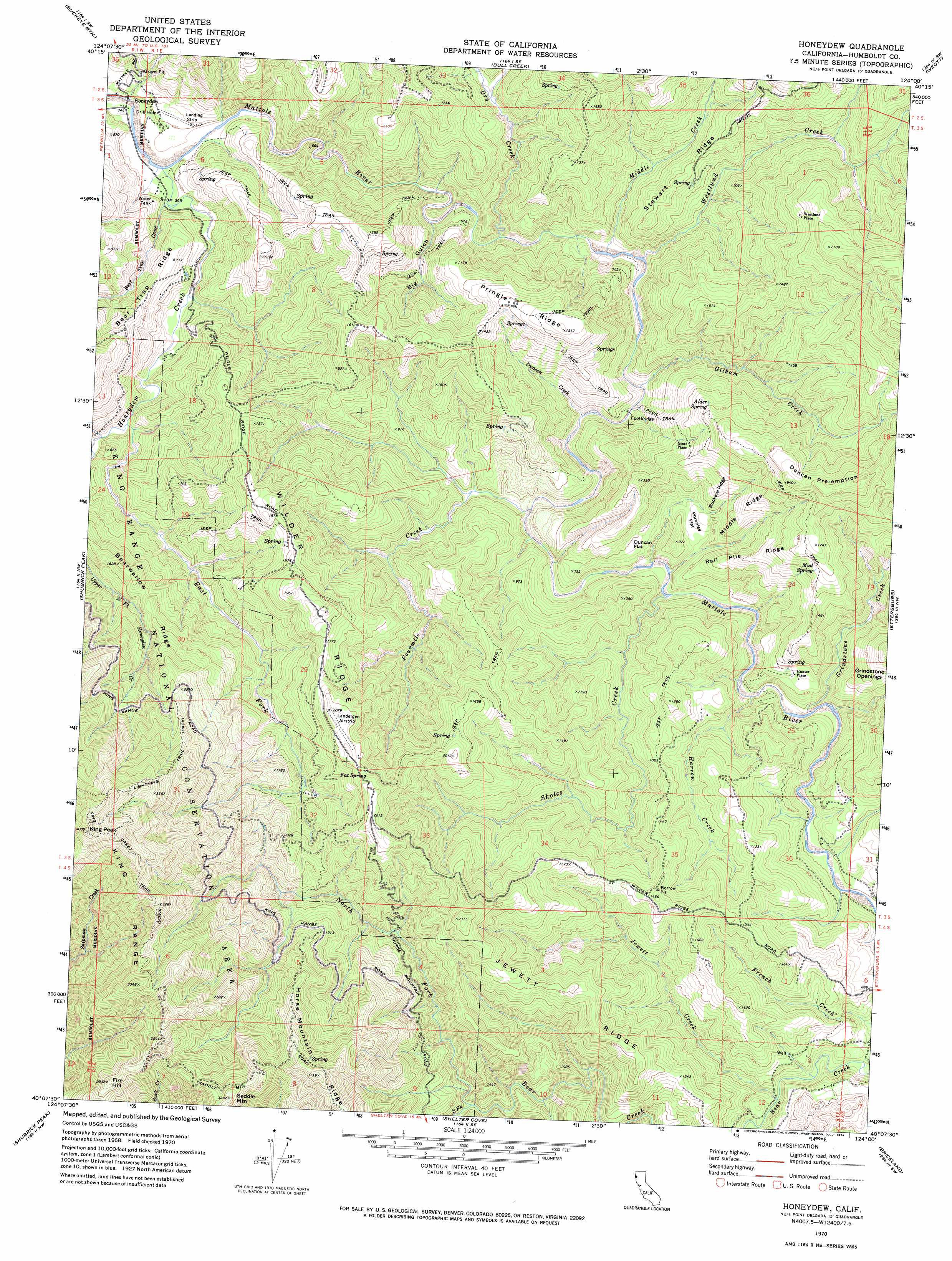
USGS Topo Quad 40124b1 - 1:24,000 scale
| Topo Map Name: | Honeydew |
| USGS Topo Quad ID: | 40124b1 |
| Print Size: | ca. 21 1/4" wide x 27" high |
| Southeast Coordinates: | 40.125° N latitude / 124° W longitude |
| Map Center Coordinates: | 40.1875° N latitude / 124.0625° W longitude |
| U.S. State: | CA |
| Filename: | o40124b1.jpg |
| Download Map JPG Image: | Honeydew topo map 1:24,000 scale |
| Map Type: | Topographic |
| Topo Series: | 7.5´ |
| Map Scale: | 1:24,000 |
| Source of Map Images: | United States Geological Survey (USGS) |
| Alternate Map Versions: |
Honeydew CA 1970, updated 1974 Download PDF Buy paper map Honeydew CA 2012 Download PDF Buy paper map Honeydew CA 2015 Download PDF Buy paper map |
1:24,000 Topo Quads surrounding Honeydew
Capetown |
Taylor Peak |
Scotia |
Redcrest |
Bridgeville |
Petrolia |
Buckeye Mountain |
Bull Creek |
Weott |
Myers Flat |
Cooskie Creek |
Shubrick Peak |
Honeydew |
Ettersburg |
Miranda |
Shelter Cove |
Briceland |
Garberville |
||
Bear Harbor |
Piercy |
> Back to 40124a1 at 1:100,000 scale
> Back to 40124a1 at 1:250,000 scale
> Back to U.S. Topo Maps home
Honeydew topo map: Gazetteer
Honeydew: Flats
Duncan Flat elevation 241m 790′Grindstone Openings elevation 374m 1227′
Phronies Flat elevation 234m 767′
Honeydew: Populated Places
Honeydew elevation 98m 321′Hunter Place elevation 272m 892′
Scott Place elevation 351m 1151′
Westlund Place elevation 522m 1712′
Honeydew: Ridges
Bearwallow Ridge elevation 493m 1617′Buckeye Ridge elevation 331m 1085′
Jewett Ridge elevation 504m 1653′
Middle Ridge elevation 357m 1171′
Pringle Ridge elevation 443m 1453′
Rail Pile Ridge elevation 379m 1243′
Stewart Ridge elevation 318m 1043′
Wilder Ridge elevation 600m 1968′
Honeydew: Springs
Alder Spring elevation 422m 1384′Fox Spring elevation 621m 2037′
Mud Spring elevation 475m 1558′
Honeydew: Streams
Bear Trap Creek elevation 106m 347′Dry Creek elevation 132m 433′
Duncan Creek elevation 147m 482′
East Fork Honeydew Creek elevation 149m 488′
Fourmile Creek elevation 165m 541′
Gilham Creek elevation 146m 479′
Grindstone Creek elevation 182m 597′
Harrow Creek elevation 164m 538′
Honeydew Creek elevation 106m 347′
Jewett Creek elevation 206m 675′
Middle Creek elevation 134m 439′
North Fork Bear Creek elevation 286m 938′
Sholes Creek elevation 158m 518′
South Fork Bear Creek elevation 287m 941′
Westlund Creek elevation 136m 446′
Honeydew: Summits
Duncan Pre-emption elevation 627m 2057′Fire Hill elevation 897m 2942′
King Peak elevation 1246m 4087′
Saddle Mountain elevation 1003m 3290′
Honeydew: Trails
Lightning Trail elevation 931m 3054′Honeydew: Valleys
Big Gulch elevation 141m 462′Honeydew digital topo map on disk
Buy this Honeydew topo map showing relief, roads, GPS coordinates and other geographical features, as a high-resolution digital map file on DVD: