Fields Landing Topo Map California
To zoom in, hover over the map of Fields Landing
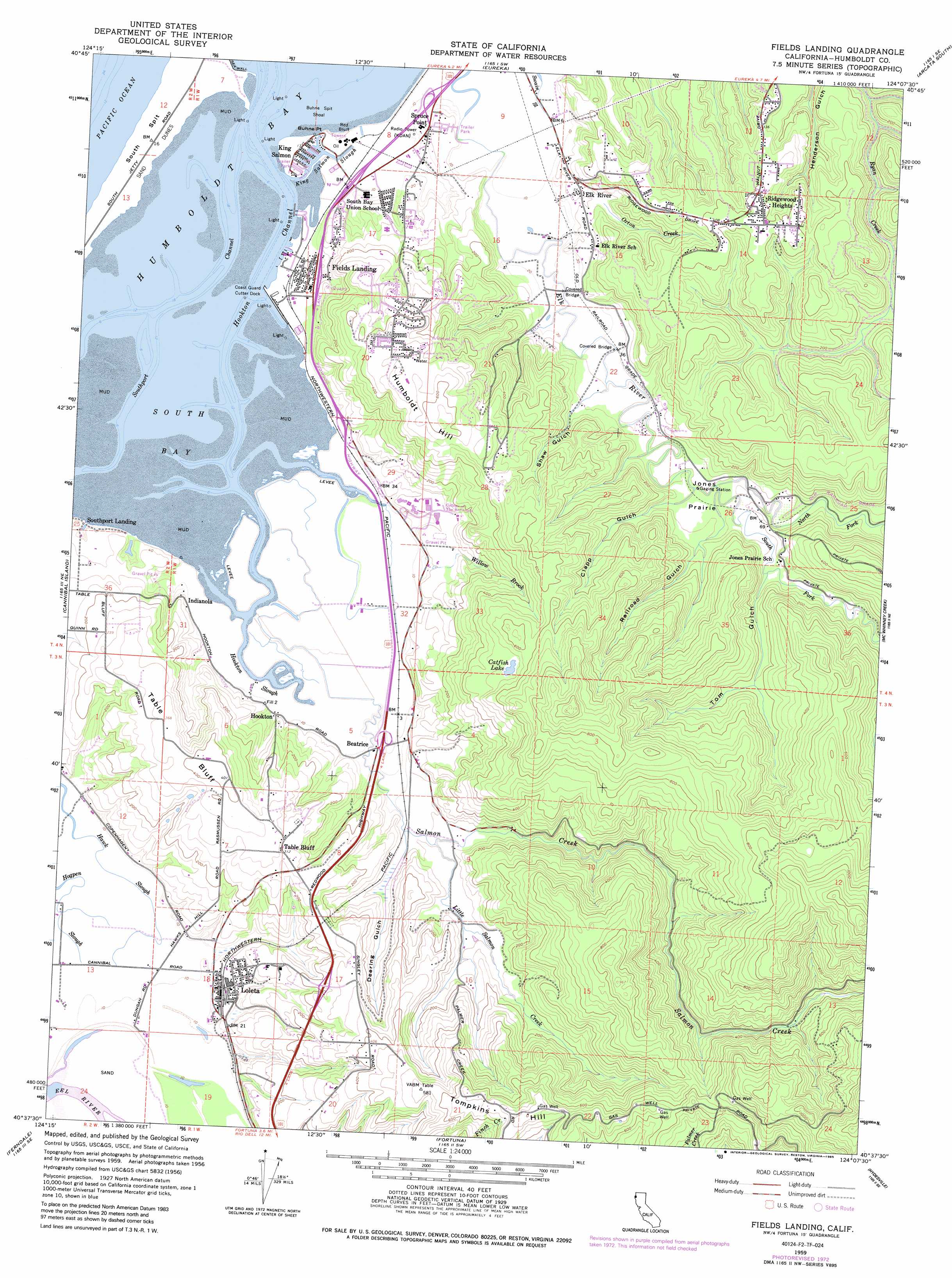
USGS Topo Quad 40124f2 - 1:24,000 scale
| Topo Map Name: | Fields Landing |
| USGS Topo Quad ID: | 40124f2 |
| Print Size: | ca. 21 1/4" wide x 27" high |
| Southeast Coordinates: | 40.625° N latitude / 124.125° W longitude |
| Map Center Coordinates: | 40.6875° N latitude / 124.1875° W longitude |
| U.S. State: | CA |
| Filename: | o40124f2.jpg |
| Download Map JPG Image: | Fields Landing topo map 1:24,000 scale |
| Map Type: | Topographic |
| Topo Series: | 7.5´ |
| Map Scale: | 1:24,000 |
| Source of Map Images: | United States Geological Survey (USGS) |
| Alternate Map Versions: |
Fields Landing CA 1959, updated 1961 Download PDF Buy paper map Fields Landing CA 1959, updated 1971 Download PDF Buy paper map Fields Landing CA 1959, updated 1985 Download PDF Buy paper map Fields Landing CA 2012 Download PDF Buy paper map Fields Landing CA 2015 Download PDF Buy paper map |
1:24,000 Topo Quads surrounding Fields Landing
Tyee City |
Arcata North |
Blue Lake |
||
Eureka |
Arcata South |
Korbel |
||
Cannibal Island |
Fields Landing |
Mcwhinney Creek |
Iaqua Buttes |
|
Ferndale |
Fortuna |
Hydesville |
Owl Creek |
|
Cape Mendocino |
Capetown |
Taylor Peak |
Scotia |
Redcrest |
> Back to 40124e1 at 1:100,000 scale
> Back to 40124a1 at 1:250,000 scale
> Back to U.S. Topo Maps home
Fields Landing topo map: Gazetteer
Fields Landing: Bars
Buhne Spit Shoal elevation 0m 0′South Spit elevation 1m 3′
Fields Landing: Bays
Humboldt Bay elevation 0m 0′South Bay elevation 0m 0′
Fields Landing: Bridges
Bertas Ranch Bridge elevation 4m 13′Zanes Ranch Bridge elevation 10m 32′
Fields Landing: Capes
Buhne Point elevation 2m 6′Fields Landing: Channels
Hookton Channel elevation 0m 0′Southport Channel elevation 0m 0′
Fields Landing: Cliffs
Red Bluff elevation 1m 3′Table Bluff elevation 55m 180′
Fields Landing: Flats
Jones Prairie elevation 13m 42′Fields Landing: Guts
Hookton Slough elevation 0m 0′Fields Landing: Islands
Teal Island elevation 1m 3′Fields Landing: Lakes
Catfish Lake elevation 156m 511′Long Pond elevation 2m 6′
Fields Landing: Parks
Humboldt Bay National Wildlife Refuge elevation 0m 0′Fields Landing: Populated Places
Beatrice elevation 5m 16′Elk River elevation 21m 68′
Fields Landing elevation 4m 13′
Hookton elevation 8m 26′
Humboldt Hill elevation 59m 193′
Indianola elevation 13m 42′
King Salmon elevation 1m 3′
Loleta elevation 14m 45′
Pine Hills elevation 128m 419′
Ridgewoods Heights elevation 127m 416′
Southport Landing elevation 2m 6′
Spruce Point elevation 15m 49′
Table Bluff elevation 97m 318′
Table Bluff Rancheria elevation 72m 236′
Fields Landing: Post Offices
Loleta Post Office elevation 13m 42′Fields Landing: Streams
King Salmon Slough elevation -2m -7′Little Salmon Creek elevation 13m 42′
North Fork Elk River elevation 13m 42′
Orton Creek elevation 27m 88′
Salmon Creek elevation 2m 6′
South Fork Elk River elevation 13m 42′
Willow Brook elevation 12m 39′
Fields Landing: Summits
Humboldt Hill elevation 200m 656′Tompkins Hill elevation 223m 731′
Fields Landing: Swamps
Triangle Marsh elevation 2m 6′Fields Landing: Trails
Hookton Slough Trail elevation 2m 6′Shorebird Loop Trail elevation 2m 6′
Fields Landing: Valleys
Clapp Gulch elevation 13m 42′Deering Gulch elevation 11m 36′
Railroad Gulch elevation 14m 45′
Shaw Gulch elevation 12m 39′
Tom Gulch elevation 21m 68′
Fields Landing digital topo map on disk
Buy this Fields Landing topo map showing relief, roads, GPS coordinates and other geographical features, as a high-resolution digital map file on DVD: