Monomoy Point Topo Map Massachusetts
To zoom in, hover over the map of Monomoy Point
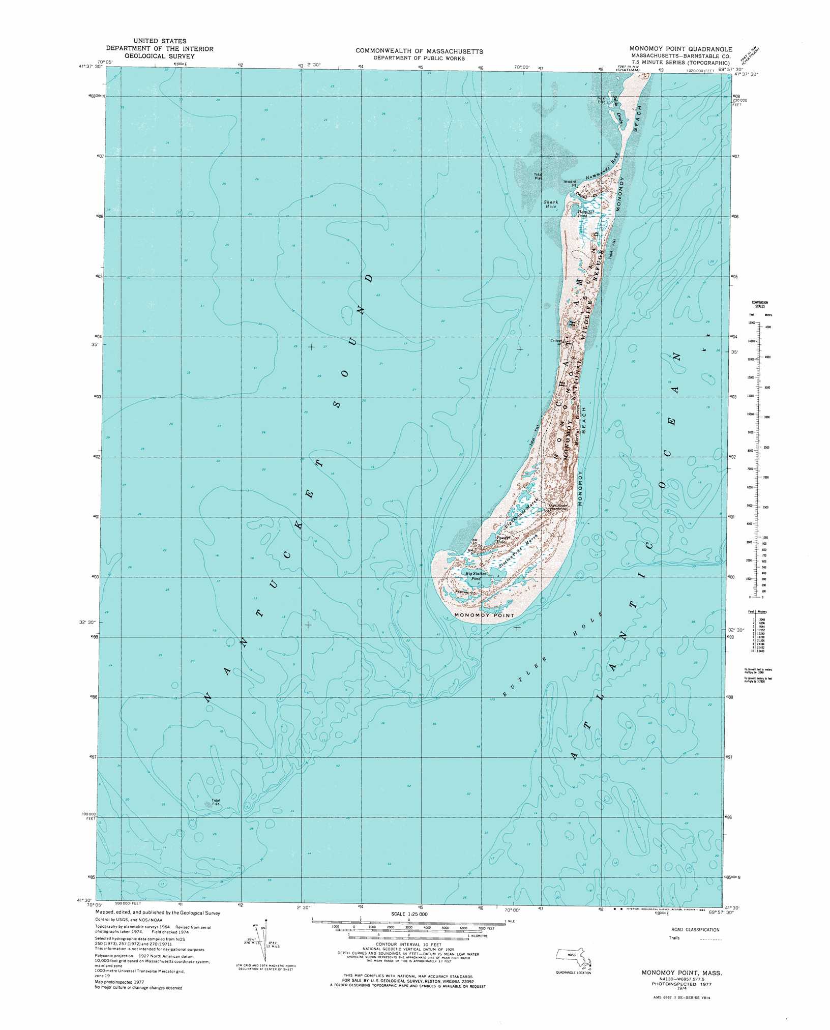
USGS Topo Quad 41069e8 - 1:25,000 scale
| Topo Map Name: | Monomoy Point |
| USGS Topo Quad ID: | 41069e8 |
| Print Size: | ca. 21 1/4" wide x 27" high |
| Southeast Coordinates: | 41.5° N latitude / 69.875° W longitude |
| Map Center Coordinates: | 41.5625° N latitude / 69.9375° W longitude |
| U.S. State: | MA |
| Filename: | l41069e8.jpg |
| Download Map JPG Image: | Monomoy Point topo map 1:25,000 scale |
| Map Type: | Topographic |
| Topo Series: | 7.5´ |
| Map Scale: | 1:25,000 |
| Source of Map Images: | United States Geological Survey (USGS) |
| Alternate Map Versions: |
1:24,000 Topo Quads surrounding Monomoy Point
Orleans |
||||
Dennis |
Harwich |
Chatham |
||
Monomoy Point |
||||
Tuckernuck Island |
Great Point |
> Back to 41069e1 at 1:100,000 scale
> Back to 41068a1 at 1:250,000 scale
> Back to U.S. Topo Maps home
Monomoy Point topo map: Gazetteer
Monomoy Point: Bars
Bearse Shoal elevation 0m 0′Broken Part of Pollock Rip elevation 0m 0′
Broken Rip elevation 0m 0′
Monomoy Shoals elevation 0m 0′
Monomoy Shoals elevation 0m 0′
Pollock Rip elevation 0m 0′
Schooner Bar elevation 0m 0′
Stone Horse Shoal elevation 0m 0′
Twelvefoot Shoal (historical) elevation 0m 0′
Monomoy Point: Bays
Blue Bill Hole elevation 0m 0′Hammonds Bend elevation 0m 0′
Shark Hole elevation 0m 0′
Monomoy Point: Capes
Inward Point elevation 0m 0′Monomoy Point: Channels
Broken Part of Pollock Rip elevation 0m 0′Butler Hole elevation 0m 0′
Pollock Rip Channel elevation 0m 0′
Pollock Rip Channel elevation 0m 0′
Monomoy Point: Guts
Salls Drain elevation 1m 3′Monomoy Point: Islands
Monomoy Island (historical) elevation 2m 6′South Monomoy Island elevation 1m 3′
Monomoy Point: Populated Places
Old Harbor elevation 2m 6′Shooters Island elevation 2m 6′
Monomoy Point: Ranges
Monomoy Island Dunes elevation 2m 6′Monomoy Point: Reservoirs
Hospital Pond elevation 0m 0′Monomoy Point: Streams
Trains Creek elevation 0m 0′Monomoy Point: Summits
Barrier Dunes elevation 4m 13′Monomoy Point: Swamps
Lighthouse Marsh elevation 1m 3′Monomoy Point digital topo map on disk
Buy this Monomoy Point topo map showing relief, roads, GPS coordinates and other geographical features, as a high-resolution digital map file on DVD:
Maine, New Hampshire, Rhode Island & Eastern Massachusetts
Buy digital topo maps: Maine, New Hampshire, Rhode Island & Eastern Massachusetts