Tuckernuck Island Topo Map Massachusetts
To zoom in, hover over the map of Tuckernuck Island
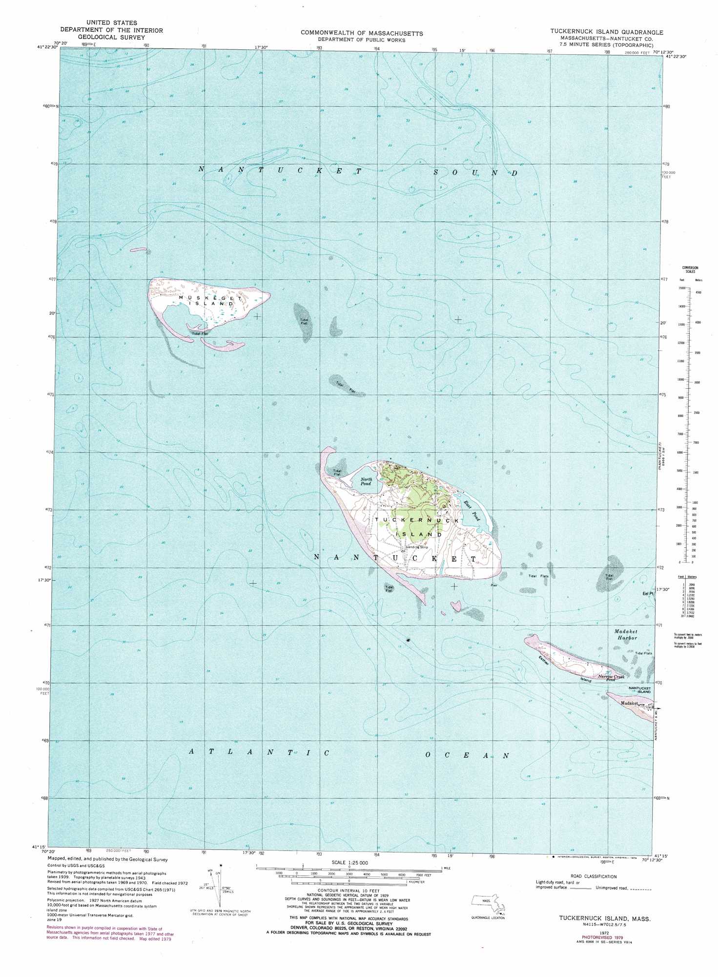
USGS Topo Quad 41070c2 - 1:25,000 scale
| Topo Map Name: | Tuckernuck Island |
| USGS Topo Quad ID: | 41070c2 |
| Print Size: | ca. 21 1/4" wide x 27" high |
| Southeast Coordinates: | 41.25° N latitude / 70.125° W longitude |
| Map Center Coordinates: | 41.3125° N latitude / 70.1875° W longitude |
| U.S. State: | MA |
| Filename: | l41070c2.jpg |
| Download Map JPG Image: | Tuckernuck Island topo map 1:25,000 scale |
| Map Type: | Topographic |
| Topo Series: | 7.5´ |
| Map Scale: | 1:25,000 |
| Source of Map Images: | United States Geological Survey (USGS) |
| Alternate Map Versions: |
1:24,000 Topo Quads surrounding Tuckernuck Island
Cotuit |
Hyannis |
Monomoy Point |
||
Edgartown |
Tuckernuck Island |
Great Point |
||
Nantucket |
Siasconset |
|||
> Back to 41070a1 at 1:100,000 scale
> Back to 41070a1 at 1:250,000 scale
> Back to U.S. Topo Maps home
Tuckernuck Island topo map: Gazetteer
Tuckernuck Island: Airports
Waine Heliport elevation 19m 62′Tuckernuck Island: Bars
East Pond elevation 0m 0′Tuckernuck Island: Basins
The Bathtub elevation 0m 0′Tuckernuck Island: Bays
Broad Creek (historical) elevation 0m 0′Clark Cove elevation 2m 6′
Jeremy Cove elevation 1m 3′
Madaket Harbor elevation 0m 0′
Nantucket Sound elevation 0m 0′
White Goose Cove elevation 1m 3′
Tuckernuck Island: Beaches
Cisco Beach elevation 3m 9′Dionis Beach elevation 0m 0′
Tuckernuck Island: Canals
Madaket Ditch elevation 0m 0′Tuckernuck Island: Capes
Eel Point elevation 0m 0′Great Neck elevation 7m 22′
Jackson Point elevation 0m 0′
Johns Point elevation 2m 6′
Little Neck elevation 0m 0′
Little Ram Pasture Point elevation 2m 6′
Nanahumas Neck elevation 6m 19′
North Point elevation 1m 3′
Ram Pasture elevation 2m 6′
Smith Point elevation 0m 0′
Smiths Point elevation 0m 0′
Tuckernuck Island: Guts
The Gut elevation 1m 3′Tuckernuck Island: Islands
Esther Island elevation 4m 13′Tuckernuck Island: Isthmuses
The Narrows elevation 2m 6′Tuckernuck Island: Lakes
Capaum Pond elevation 1m 3′Head of Hummock elevation 2m 6′
Hummock Pond elevation 2m 6′
Long Pond elevation 1m 3′
Maxcy Pond elevation 2m 6′
Narrow Creek Pond elevation 0m 0′
North Head Long Pond elevation 1m 3′
Peat Hole elevation 5m 16′
Reedy Pond elevation 1m 3′
Rotten Pumpkin Pond elevation 6m 19′
Sheep Pond elevation 7m 22′
Waqutuquaib Ponds elevation 4m 13′
Washing Pond elevation 2m 6′
Tuckernuck Island: Parks
Nantucket Conservation Foundation elevation 5m 16′Tuckernuck Island: Populated Places
Cisco elevation 6m 19′Fishers Landing elevation 1m 3′
Further Creek (historical) elevation 2m 6′
Head of Plains (historical) elevation 7m 22′
Madaket elevation 8m 26′
Maddequet (historical) elevation 1m 3′
Narrow Creek (historical) elevation 0m 0′
Shallow Pond elevation 7m 22′
The Plains (historical) elevation 6m 19′
Trots Hills elevation 7m 22′
Warren Landing elevation 0m 0′
Tuckernuck Island: Streams
Hither Creek elevation 0m 0′Tuckernuck Island: Summits
Long Hill elevation 6m 19′Swain Hill elevation 16m 52′
Trots Hills elevation 16m 52′
Tuckernuck Island: Swamps
Eel Point Marsh elevation 1m 3′George Easton Swamps elevation 3m 9′
Larrabee Swamp elevation 3m 9′
North Pond elevation 2m 6′
Round O Swamp elevation 1m 3′
Trots Swamp elevation 2m 6′
Tuckernuck Island: Valleys
Quampache Bottom elevation 8m 26′Tuckernuck Island: Woods
The Woods elevation 12m 39′Tuckernuck Island digital topo map on disk
Buy this Tuckernuck Island topo map showing relief, roads, GPS coordinates and other geographical features, as a high-resolution digital map file on DVD:
Maine, New Hampshire, Rhode Island & Eastern Massachusetts
Buy digital topo maps: Maine, New Hampshire, Rhode Island & Eastern Massachusetts