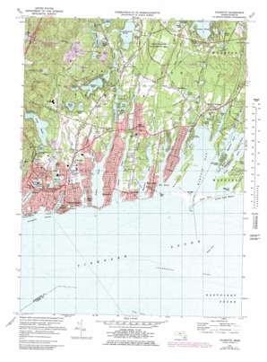
Falmouth Topo Map Massachusetts
To zoom in, hover over the map of Falmouth
USGS Topo Quad 41070e5 - 1:25,000 scale
| Topo Map Name: | Falmouth |
| USGS Topo Quad ID: | 41070e5 |
| Print Size: | ca. 21 1/4" wide x 27" high |
| Southeast Coordinates: | 41.5° N latitude / 70.5° W longitude |
| Map Center Coordinates: | 41.5625° N latitude / 70.5625° W longitude |
| U.S. State: | MA |
| Filename: | l41070e5.jpg |
| Download Map JPG Image: | Falmouth topo map 1:25,000 scale |
| Map Type: | Topographic |
| Topo Series: | 7.5´ |
| Map Scale: | 1:25,000 |
| Source of Map Images: | United States Geological Survey (USGS) |
| Alternate Map Versions: |
Falmouth MA 1936 Download PDF Buy paper map Falmouth MA 1948, updated 1949 Download PDF Buy paper map Falmouth MA 1949, updated 1949 Download PDF Buy paper map Falmouth MA 1972, updated 1979 Download PDF Buy paper map Falmouth MA 1972, updated 1979 Download PDF Buy paper map Falmouth MA 1977, updated 1981 Download PDF Buy paper map |
1:24,000 Topo Quads surrounding Falmouth
Snipatuit Pond |
Wareham |
Sagamore |
||
Marion |
Onset |
Pocasset |
Sandwich |
|
Sconticut Neck |
Woods Hole |
Falmouth |
Cotuit |
Hyannis |
Cuttyhunk |
Nauson Island |
Vineyard Haven |
||
Squibnocket |
Tisbury Great Pond |
Edgartown |
> Back to 41070e1 at 1:100,000 scale
> Back to 41070a1 at 1:250,000 scale
> Back to U.S. Topo Maps home
Falmouth topo map: Gazetteer
Falmouth: Airports
Falmouth Airpark elevation 12m 39′Falmouth Hospital Heliport elevation 28m 91′
Fuller House Heliport elevation 2m 6′
Falmouth: Areas
Crane Wildlife Management Area elevation 16m 52′Falmouth: Bars
Bardow Shoal elevation 0m 0′L'Hommedieu Shoal elevation 0m 0′
Falmouth: Bays
Bournes Pond elevation 0m 0′Eel Pond elevation 0m 0′
Falmouth Inner Harbor elevation 3m 9′
Great Pond elevation -2m -7′
Great River elevation 0m 0′
Green Pond elevation 1m 3′
Hamblin Pond elevation 0m 0′
Israels Cove elevation 0m 0′
Waquoit Bay elevation 0m 0′
Falmouth: Beaches
Menauhant Beach elevation 0m 0′South Cape Beach elevation 1m 3′
Falmouth: Capes
Bournes Neck elevation 3m 9′Davis Neck elevation 8m 26′
Dead Neck elevation 2m 6′
Hamblens Point elevation 0m 0′
Lawrences Neck elevation 4m 13′
Meadow Neck elevation 0m 0′
Seconsett Island elevation 4m 13′
Falmouth: Channels
Little River elevation 0m 0′Falmouth: Dams
Coonamesset Pond Dam elevation 15m 49′Mill Pond Dam elevation 6m 19′
Parker Road Bog Dam elevation 4m 13′
Red Brook Road Dam elevation 3m 9′
Falmouth: Harbors
Falmouth Harbor elevation 0m 0′Falmouth: Islands
Washburn Island elevation 7m 22′Falmouth: Lakes
Bog Pond elevation 1m 3′Bourne Pond elevation 1m 3′
Caleb Pond elevation 1m 3′
Crocker Pond elevation 6m 19′
Crooked Pond elevation 9m 29′
Deep Pond elevation 11m 36′
Deer Pond elevation 5m 16′
Flashy Pond elevation 17m 55′
Flax Pond elevation 19m 62′
Fresh Pond elevation 6m 19′
Grassy Pond elevation 13m 42′
Grews Pond elevation 3m 9′
James Pond elevation 12m 39′
Jenkins Pond elevation 19m 62′
Jenkins Pond elevation 6m 19′
Jones Pond elevation 2m 6′
Little Pond elevation -7m -23′
Long Pond elevation 3m 9′
Mares Pond elevation 4m 13′
Martha Pond elevation 15m 49′
Morse Pond elevation 2m 6′
Nye Pond elevation 2m 6′
Randal Pond elevation 9m 29′
Round Pond elevation 6m 19′
Round Pond elevation 11m 36′
Sage Lot Pond elevation 0m 0′
Shallow Pond elevation 8m 26′
Shivericks Pond elevation 2m 6′
Siders Pond elevation 2m 6′
Sols Pond elevation 2m 6′
Spectacle Pond elevation 9m 29′
Spectacle Pond elevation 4m 13′
Tim Pond elevation 12m 39′
Falmouth: Parks
Ashumet Holl Reservation elevation 17m 55′Fuller Field elevation 1m 3′
Goodwill Park elevation 3m 9′
Marine Park elevation 1m 3′
Falmouth: Populated Places
Acapesket elevation 2m 6′Davisville elevation 6m 19′
East Falmouth elevation 11m 36′
Falmouth elevation 2m 6′
Falmouth Heights elevation 0m 0′
Kingdom Hall elevation 8m 26′
Mara Vista elevation -4m -14′
Menauhant elevation 3m 9′
Monomoscoy Island elevation 2m 6′
Seconsett Island elevation 5m 16′
Smalltown elevation 16m 52′
Teaticket elevation 8m 26′
Waquoit Village elevation 13m 42′
Falmouth: Reservoirs
Coonamessett Pond elevation 15m 49′Mill Pond elevation 5m 16′
Parker Road Pond elevation 4m 13′
Red Brook Reservoir elevation 3m 9′
Falmouth: Streams
Bournes Brook (historical) elevation 6m 19′Childs River elevation 0m 0′
Coonamessett River elevation 0m 0′
Quashnet River elevation 0m 0′
Red Brook elevation 2m 6′
Seapit River elevation 0m 0′
Falmouth: Swamps
Lewis Neck elevation 6m 19′Moromoesoy Island elevation 0m 0′
Falmouth digital topo map on disk
Buy this Falmouth topo map showing relief, roads, GPS coordinates and other geographical features, as a high-resolution digital map file on DVD:
Maine, New Hampshire, Rhode Island & Eastern Massachusetts
Buy digital topo maps: Maine, New Hampshire, Rhode Island & Eastern Massachusetts


