Woods Hole Topo Map Massachusetts
To zoom in, hover over the map of Woods Hole
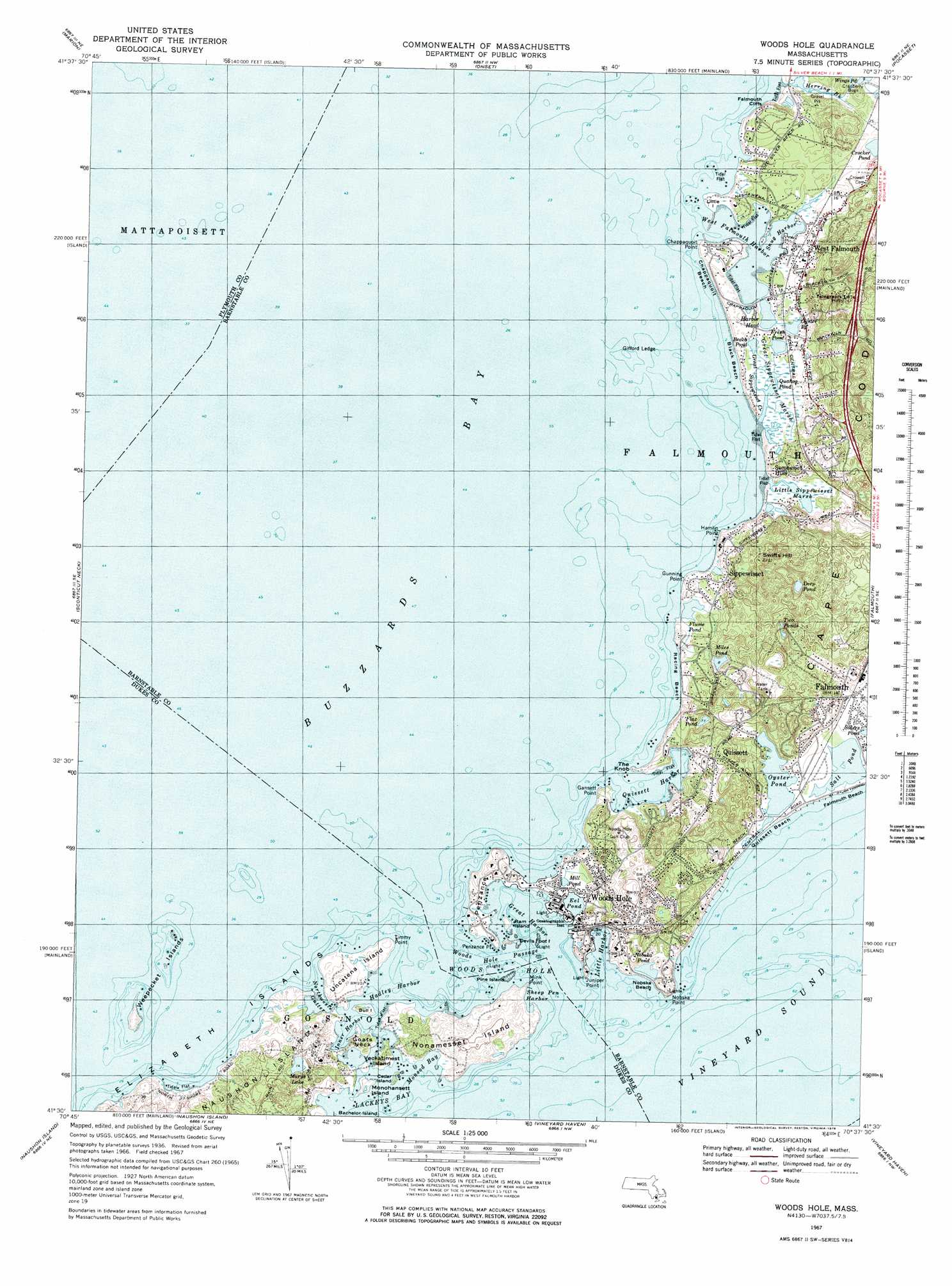
USGS Topo Quad 41070e6 - 1:25,000 scale
| Topo Map Name: | Woods Hole |
| USGS Topo Quad ID: | 41070e6 |
| Print Size: | ca. 21 1/4" wide x 27" high |
| Southeast Coordinates: | 41.5° N latitude / 70.625° W longitude |
| Map Center Coordinates: | 41.5625° N latitude / 70.6875° W longitude |
| U.S. State: | MA |
| Filename: | l41070e6.jpg |
| Download Map JPG Image: | Woods Hole topo map 1:25,000 scale |
| Map Type: | Topographic |
| Topo Series: | 7.5´ |
| Map Scale: | 1:25,000 |
| Source of Map Images: | United States Geological Survey (USGS) |
| Alternate Map Versions: |
Woods Hole MA 1967, updated 1978 Download PDF Buy paper map Woods Hole MA 1967, updated 1978 Download PDF Buy paper map Woods Hole MA 1977, updated 1981 Download PDF Buy paper map |
1:24,000 Topo Quads surrounding Woods Hole
Assawompset Pond |
Snipatuit Pond |
Wareham |
Sagamore |
|
New Bedford North |
Marion |
Onset |
Pocasset |
Sandwich |
New Bedford South |
Sconticut Neck |
Woods Hole |
Falmouth |
Cotuit |
Cuttyhunk |
Nauson Island |
Vineyard Haven |
||
Squibnocket |
Tisbury Great Pond |
Edgartown |
> Back to 41070e1 at 1:100,000 scale
> Back to 41070a1 at 1:250,000 scale
> Back to U.S. Topo Maps home
Woods Hole topo map: Gazetteer
Woods Hole: Airports
Woods Hole Oceanographic Institute Seaplane Base elevation 0m 0′Woods Hole: Bars
Great Sippewisset Rock elevation 0m 0′Hadley Rock elevation 0m 0′
Nobska Point Ledge elevation 0m 0′
Nonamesset Shoal elevation 0m 0′
Red Ledge elevation 0m 0′
Red Ledge elevation 0m 0′
Timmy Point Shoal elevation 0m 0′
Woods Hole: Bays
Buzzards Bay elevation 0m 0′Great Harbor elevation 0m 0′
Hadley Harbor elevation 0m 0′
Lackeys Bay elevation 0m 0′
Monsod Bay elevation 1m 3′
Quissett Harbor elevation 0m 0′
Woods Hole: Beaches
Black Beach elevation 0m 0′Chappaquoit Beach elevation 0m 0′
Falmouth Beach elevation 1m 3′
Nobska Beach elevation 2m 6′
Quissett Beach elevation 2m 6′
Woods Hole: Capes
Chappaquoit Point elevation 7m 22′Gansett Point elevation 0m 0′
Goats Neck elevation 4m 13′
Gunning Point elevation 0m 0′
Hamlin Point elevation 0m 0′
Juniper Point elevation 6m 19′
Little Island elevation 2m 6′
Mink Point elevation 0m 0′
Nonamesset Point elevation 0m 0′
Penzance elevation 0m 0′
Penzance Point elevation 2m 6′
Timmy Point elevation 1m 3′
Woods Hole: Channels
Branch elevation 0m 0′Broadway elevation 0m 0′
Woods Hole Passage elevation 0m 0′
Woods Hole: Cliffs
Falmouth Cliffs elevation 6m 19′Falmouth Heights elevation 7m 22′
Nobska Point elevation 0m 0′
Woods Hole: Flats
Parker Flats elevation 0m 0′Woods Hole: Guts
East Gutter elevation 0m 0′Gate of Canso elevation 1m 3′
Middle Gate elevation 0m 0′
Northwest Gutter elevation 0m 0′
West Gutter elevation -4m -14′
Woods Hole: Harbors
Inner Harbor elevation 0m 0′Little Harbor elevation 0m 0′
Sheep Pen Harbor elevation 1m 3′
Snug Harbor elevation 1m 3′
West Falmouth Harbor elevation 2m 6′
Woods Hole elevation 0m 0′
Woods Hole: Islands
Bachelor Island elevation 0m 0′Bull Island elevation 1m 3′
Cedar Island elevation 0m 0′
Coffin Rock elevation 0m 0′
Devils Foot Island elevation 0m 0′
Gifford Ledge elevation 0m 0′
Grassy Island elevation 0m 0′
Great Ledge elevation 0m 0′
Hursell Rock elevation 0m 0′
Middle Ledge elevation 0m 0′
Monohansett Island elevation -2m -7′
Nonamesset Island elevation 17m 55′
Pine Island elevation 0m 0′
Pulpit Rock elevation 0m 0′
Ram Island elevation 0m 0′
Uncatena Island elevation 6m 19′
Veckatimest Island elevation 8m 26′
Weepecket Island elevation 3m 9′
Weepecket Islands elevation 0m 0′
Weepecket Rock elevation 0m 0′
Woods Hole: Lakes
Beach Pond elevation 0m 0′Deep Pond elevation 0m 0′
Eel Pond elevation 0m 0′
Flax Pond elevation 7m 22′
Flume Pond elevation 0m 0′
Fresh Pond elevation 1m 3′
Harbor Head elevation 0m 0′
Marys Lake elevation 7m 22′
Miles Pond elevation 2m 6′
Mill Pond elevation 0m 0′
Mink Pond elevation 0m 0′
Nobska Pond elevation 0m 0′
Oyster Pond elevation -4m -14′
Quahog Pond elevation 1m 3′
Salt Pond elevation -11m -37′
Two Ponds elevation 18m 59′
Woods Hole: Populated Places
Chappaquoit elevation 7m 22′Quissett elevation 16m 52′
Racing Beach elevation 0m 0′
Saconesset Hills elevation 4m 13′
Sippewisset elevation 11m 36′
West Falmouth elevation 2m 6′
Woods Hole elevation 6m 19′
Woods Hole: Streams
Great Sippewisset Creek elevation 0m 0′Herring Brook elevation 9m 29′
Woods Hole: Summits
Mount Sod elevation 9m 29′Nobska Hill elevation 14m 45′
Riddle Hill elevation 27m 88′
Swifts Hill elevation 37m 121′
Telegraph Hill elevation 45m 147′
The Knob elevation 0m 0′
Woods Hole: Swamps
Great Sippewisset Marsh elevation 0m 0′Little Sippewisset Marsh elevation 0m 0′
Woods Hole digital topo map on disk
Buy this Woods Hole topo map showing relief, roads, GPS coordinates and other geographical features, as a high-resolution digital map file on DVD:
Maine, New Hampshire, Rhode Island & Eastern Massachusetts
Buy digital topo maps: Maine, New Hampshire, Rhode Island & Eastern Massachusetts