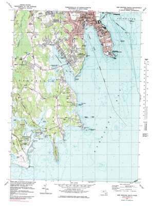
New Bedford South Topo Map Massachusetts
To zoom in, hover over the map of New Bedford South
USGS Topo Quad 41070e8 - 1:25,000 scale
| Topo Map Name: | New Bedford South |
| USGS Topo Quad ID: | 41070e8 |
| Print Size: | ca. 21 1/4" wide x 27" high |
| Southeast Coordinates: | 41.5° N latitude / 70.875° W longitude |
| Map Center Coordinates: | 41.5625° N latitude / 70.9375° W longitude |
| U.S. State: | MA |
| Filename: | l41070e8.jpg |
| Download Map JPG Image: | New Bedford South topo map 1:25,000 scale |
| Map Type: | Topographic |
| Topo Series: | 7.5´ |
| Map Scale: | 1:25,000 |
| Source of Map Images: | United States Geological Survey (USGS) |
| Alternate Map Versions: |
New Bedford South MA 1977, updated 1979 Download PDF Buy paper map New Bedford South MA 1977, updated 1981 Download PDF Buy paper map New Bedford South MA 1977, updated 1983 Download PDF Buy paper map |
1:24,000 Topo Quads surrounding New Bedford South
Assonet |
Assawompset Pond |
Snipatuit Pond |
Wareham |
|
Fall River East |
New Bedford North |
Marion |
Onset |
|
Westport |
New Bedford South |
Sconticut Neck |
Woods Hole |
|
Sakonnet Point |
Cuttyhunk |
Nauson Island |
||
Squibnocket |
> Back to 41070e1 at 1:100,000 scale
> Back to 41070a1 at 1:250,000 scale
> Back to U.S. Topo Maps home
New Bedford South topo map: Gazetteer
New Bedford South: Bars
Barekneed Rocks elevation 0m 0′Dumpling Rocks elevation 0m 0′
Great Ledge elevation 0m 0′
Lazy Rocks elevation 0m 0′
Ragged Rocks elevation 0m 0′
Salters Point Ledge elevation 0m 0′
The Sandspit elevation 0m 0′
New Bedford South: Bays
Apponagansett Bay elevation 0m 0′Clarks Cove elevation 0m 0′
Giles Creek elevation -3m -10′
Slocums River elevation -3m -10′
New Bedford South: Bridges
Plummer Memorial Bridge elevation 1m 3′New Bedford South: Capes
Barneys Joy Point elevation 0m 0′Clarks Point elevation 0m 0′
Deepwater Point elevation 0m 0′
Great Neck elevation 7m 22′
Mishaum Point elevation 0m 0′
Moshers Point elevation 0m 0′
Potomska Point elevation 5m 16′
Ricketsons Point elevation 3m 9′
Round Hill Point elevation 0m 0′
Salters Point elevation 0m 0′
Slocums Neck elevation 4m 13′
Smith Neck elevation 15m 49′
New Bedford South: Dams
Hunts Rock Breakwater elevation 0m 0′Padanaram Breakwater elevation 0m 0′
New Bedford South: Flats
Butler Flats elevation 0m 0′Fort Flat elevation 0m 0′
New Bedford South: Islands
Bents Ledge elevation 0m 0′Brooklyn Rock elevation 0m 0′
Cedar Island elevation 1m 3′
Church Rock elevation 0m 0′
Dartmouth Rock elevation 0m 0′
Decatur Rock elevation 0m 0′
Egg Island elevation 0m 0′
Fatal Rock elevation 0m 0′
Hunts Rock elevation 0m 0′
Hussey Rock elevation 0m 0′
Inez Rock elevation 0m 0′
Keel Rock elevation 0m 0′
Little Egg Island elevation 0m 0′
Little Island elevation 1m 3′
Lone Rock elevation 0m 0′
Middle Ledge elevation 0m 0′
North Ledge elevation 0m 0′
Old Bartlemy elevation 4m 13′
Pawn Rock elevation 0m 0′
Pelegs Island elevation 0m 0′
Phinney Rock elevation 0m 0′
Slocums Ledge elevation 0m 0′
White Rock elevation 0m 0′
Wilkes Ledge elevation 0m 0′
New Bedford South: Lakes
Georges Pond elevation 0m 0′New Bedford South: Parks
Apponagansett Point Recreation Area elevation 1m 3′Ashley Park elevation 0m 0′
Demarest Lloyd Memorial State Park elevation 1m 3′
Fort Phoenix Beach State Reservation elevation 0m 0′
Hazelwood Park elevation 7m 22′
Jones Park elevation 0m 0′
New Bedford South: Populated Places
Apponagansett elevation 3m 9′Bayview elevation 14m 45′
Bliss Corner elevation 20m 65′
Cow Yard elevation 3m 9′
Cranberry Bog Corner elevation 39m 127′
Great Neck elevation 7m 22′
Macomber Corner elevation 18m 59′
Nonquitt elevation 20m 65′
Redgate Corner elevation 20m 65′
Shore Acres elevation 12m 39′
South Dartmouth elevation 23m 75′
Wilburite Corner elevation 19m 62′
New Bedford South: Streams
Buttonwood Brook elevation 0m 0′Little River elevation 0m 0′
New Bedford South: Summits
Pinnacle Rock elevation 18m 59′Round Hill elevation 11m 36′
New Bedford South: Swamps
Bay View Marshes elevation 4m 13′New Bedford South digital topo map on disk
Buy this New Bedford South topo map showing relief, roads, GPS coordinates and other geographical features, as a high-resolution digital map file on DVD:
Maine, New Hampshire, Rhode Island & Eastern Massachusetts
Buy digital topo maps: Maine, New Hampshire, Rhode Island & Eastern Massachusetts


