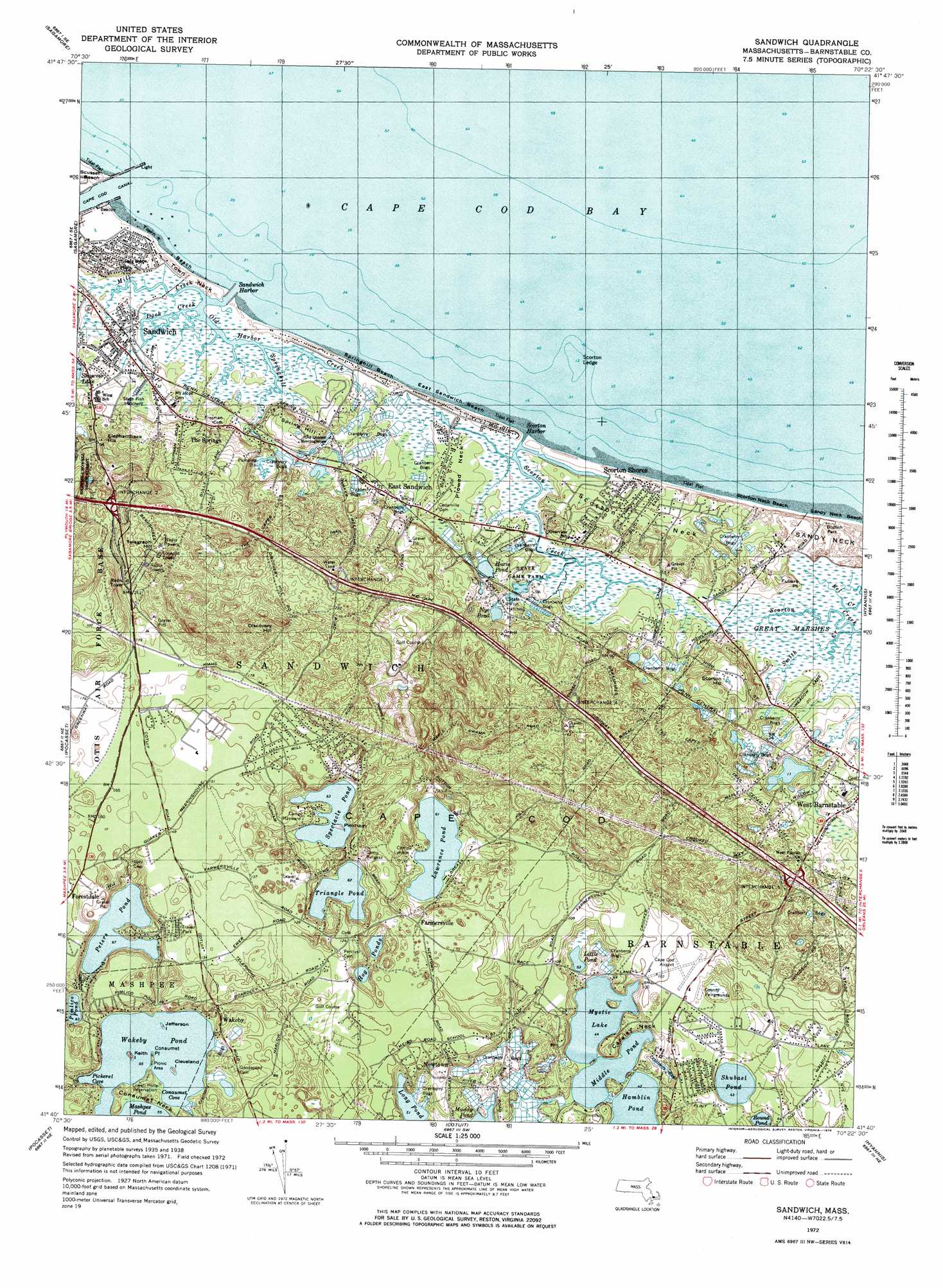
Sandwich Topo Map Massachusetts
To zoom in, hover over the map of Sandwich
USGS Topo Quad 41070f4 - 1:25,000 scale
| Topo Map Name: | Sandwich |
| USGS Topo Quad ID: | 41070f4 |
| Print Size: | ca. 21 1/4" wide x 27" high |
| Southeast Coordinates: | 41.625° N latitude / 70.375° W longitude |
| Map Center Coordinates: | 41.6875° N latitude / 70.4375° W longitude |
| U.S. State: | MA |
| Filename: | l41070f4.jpg |
| Download Map JPG Image: | Sandwich topo map 1:25,000 scale |
| Map Type: | Topographic |
| Topo Series: | 7.5´ |
| Map Scale: | 1:25,000 |
| Source of Map Images: | United States Geological Survey (USGS) |
| Alternate Map Versions: |
1:24,000 Topo Quads surrounding Sandwich
Plymouth |
Manomet |
|||
Wareham |
Sagamore |
|||
Onset |
Pocasset |
Sandwich |
Dennis |
|
Woods Hole |
Falmouth |
Cotuit |
Hyannis |
|
Nauson Island |
Vineyard Haven |
> Back to 41070e1 at 1:100,000 scale
> Back to 41070a1 at 1:250,000 scale
> Back to U.S. Topo Maps home
Sandwich topo map: Gazetteer
Sandwich: Airports
Cape Cod Airport elevation 31m 101′Marston Mills Heliport elevation 3m 9′
North Bay Heliport elevation 0m 0′
Sandwich: Bays
Conaumet Cove elevation 17m 55′Eleanors Cove elevation 17m 55′
North Bay elevation 0m 0′
Pickerel Cove elevation 17m 55′
Prince Cove elevation 0m 0′
Sams Cove elevation 17m 55′
Uncle Georges Cove elevation 17m 55′
Sandwich: Beaches
Sandy Neck Beach elevation 0m 0′Scorton Neck Beach elevation 0m 0′
Sandwich: Capes
Baxter Neck elevation 11m 36′Briants Neck elevation 13m 42′
Carsley Neck elevation 23m 75′
Conaumet Neck elevation 17m 55′
Conaumet Point elevation 17m 55′
Pine Island elevation 4m 13′
Plowed Neck elevation 0m 0′
Point Isabella elevation 0m 0′
Saint Marys Island elevation 6m 19′
Sandwich: Cliffs
Fullers Point elevation 11m 36′Sandwich: Crossings
Interchange Five elevation 30m 98′Interchange Four elevation 36m 118′
Interchange Three elevation 51m 167′
Interchange Two elevation 45m 147′
Sandwich: Dams
Mashpee River Dam elevation 19m 62′Sandwich: Harbors
Scorton Harbor elevation 3m 9′Sandwich: Islands
Cleveland Island elevation 18m 59′Jefferson Island elevation 17m 55′
Keith Island elevation 17m 55′
Pinkham Island elevation 23m 75′
Sandwich: Lakes
Amos Pond elevation 13m 42′Bog Pond elevation 0m 0′
Combs Pond elevation 10m 32′
Dam Pond elevation 2m 6′
Doughnut Pond elevation 18m 59′
Eagle Pond elevation 6m 19′
Hamblin Pond elevation 13m 42′
Hog Ponds elevation 20m 65′
Hoxie Pond elevation 8m 26′
Ishem Pond elevation 6m 19′
Joshua Pond elevation 4m 13′
Lawrence Pond elevation 19m 62′
Lily Pond elevation 20m 65′
Little Pond elevation 16m 52′
Long Pond elevation 16m 52′
Lovells Pond elevation 12m 39′
Lumbert Pond elevation 7m 22′
Mashpee Pond elevation 17m 55′
Micah Pond elevation 4m 13′
Middle Pond elevation 13m 42′
Mill Pond elevation 5m 16′
Mill Pond elevation 3m 9′
Muddy Pond elevation 14m 45′
Mystic Lake elevation 13m 42′
Naomi Pond elevation 11m 36′
North Pond elevation 1m 3′
Nye Pond elevation 5m 16′
Pattys Pond elevation 11m 36′
Peters Pond elevation 20m 65′
Pimlico Pond elevation 18m 59′
Round Pond elevation 9m 29′
Sam Pond elevation 2m 6′
Santuit Pond elevation 13m 42′
Shubael Pond elevation 13m 42′
Spectacle Pond elevation 19m 62′
Triangle Pond elevation 19m 62′
Wakeby Pond elevation 17m 55′
Washburn pond elevation 13m 42′
West Pond elevation 2m 6′
Sandwich: Parks
Bodfish Park elevation 0m 0′Lowell Holly Reservation elevation 21m 68′
Massachusetts State Game Farm elevation 9m 29′
Massachusetts State Game Farm elevation 7m 22′
Sandwich: Populated Places
Camp Burgess elevation 26m 85′East Sandwich elevation 9m 29′
Farmersville elevation 38m 124′
Forestdale elevation 50m 164′
Marstons Mills elevation 13m 42′
Mashpee elevation 22m 72′
Newtown elevation 20m 65′
Old Quaker Meetinghouse elevation 6m 19′
Osterville elevation 10m 32′
Plowed Neck elevation 7m 22′
Pondsville elevation 31m 101′
Santuit elevation 16m 52′
Scorton Shores elevation 5m 16′
The Springs elevation 25m 82′
Wakeby elevation 37m 121′
Sandwich: Streams
Long Creek elevation 3m 9′Long Creek elevation 2m 6′
Marstons Mill River elevation 5m 16′
Smith Creek elevation 1m 3′
Sandwich: Summits
Discovery Hill elevation 77m 252′Elephantback Hill elevation 20m 65′
Scorton Hill elevation 35m 114′
Spring Hill elevation 17m 55′
Telegraph Hill elevation 85m 278′
Sandwich: Swamps
Scorton Creek Marshes elevation 0m 0′Whitcomb Swamp elevation 12m 39′
Sandwich: Trails
Old Briar Patch Trails elevation 22m 72′Sandwich digital topo map on disk
Buy this Sandwich topo map showing relief, roads, GPS coordinates and other geographical features, as a high-resolution digital map file on DVD:
Maine, New Hampshire, Rhode Island & Eastern Massachusetts
Buy digital topo maps: Maine, New Hampshire, Rhode Island & Eastern Massachusetts