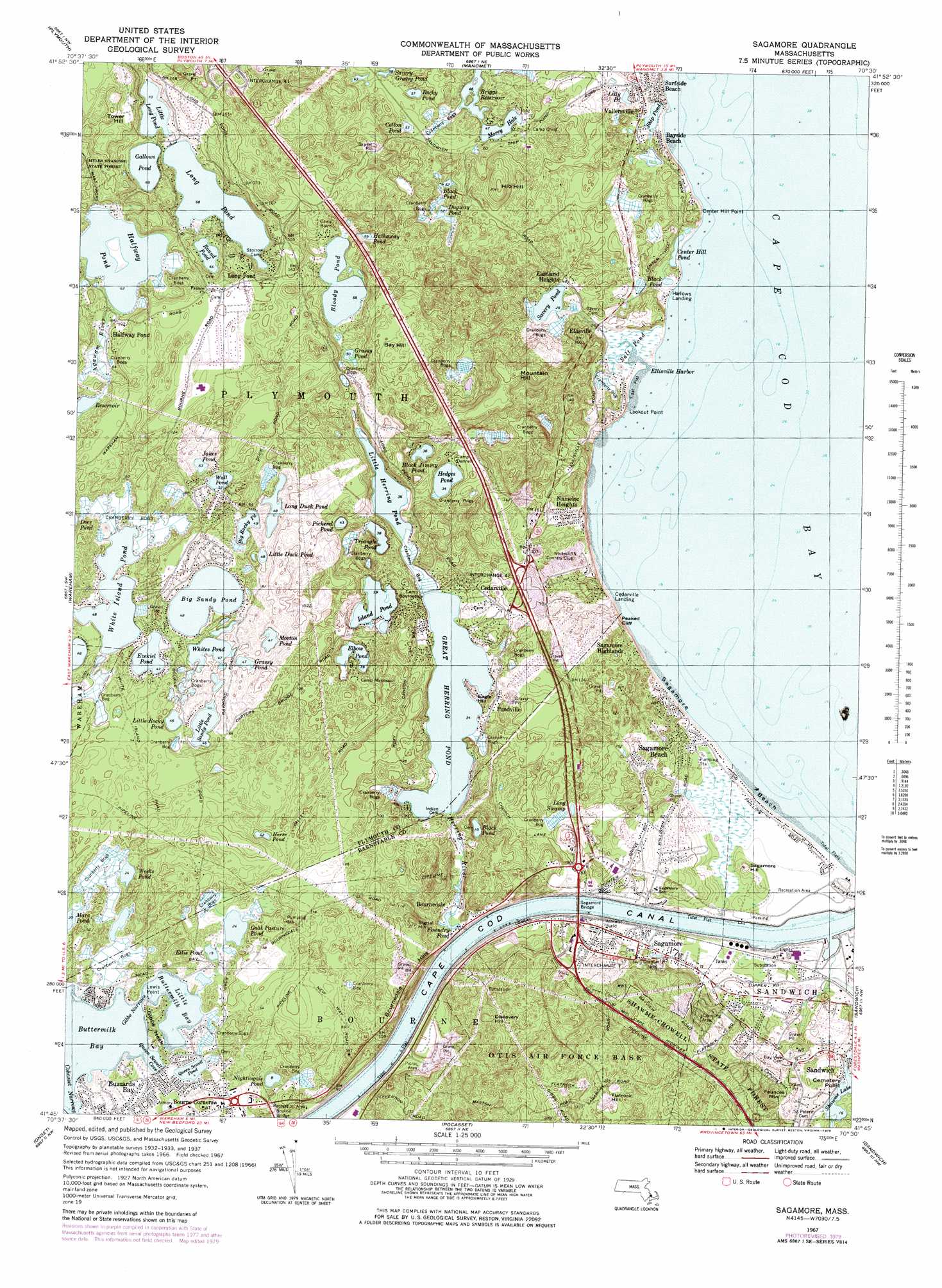
Sagamore Topo Map Massachusetts
To zoom in, hover over the map of Sagamore
USGS Topo Quad 41070g5 - 1:25,000 scale
| Topo Map Name: | Sagamore |
| USGS Topo Quad ID: | 41070g5 |
| Print Size: | ca. 21 1/4" wide x 27" high |
| Southeast Coordinates: | 41.75° N latitude / 70.5° W longitude |
| Map Center Coordinates: | 41.8125° N latitude / 70.5625° W longitude |
| U.S. State: | MA |
| Filename: | l41070g5.jpg |
| Download Map JPG Image: | Sagamore topo map 1:25,000 scale |
| Map Type: | Topographic |
| Topo Series: | 7.5´ |
| Map Scale: | 1:25,000 |
| Source of Map Images: | United States Geological Survey (USGS) |
| Alternate Map Versions: |
Sagamore MA 1967, updated 1979 Download PDF Buy paper map Sagamore MA 1967, updated 1979 Download PDF Buy paper map Sagamore MA 1977, updated 1981 Download PDF Buy paper map |
1:24,000 Topo Quads surrounding Sagamore
Hanover |
Duxbury |
|||
Plympton |
Plymouth |
Manomet |
||
Snipatuit Pond |
Wareham |
Sagamore |
||
Marion |
Onset |
Pocasset |
Sandwich |
|
Sconticut Neck |
Woods Hole |
Falmouth |
Cotuit |
Hyannis |
> Back to 41070e1 at 1:100,000 scale
> Back to 41070a1 at 1:250,000 scale
> Back to U.S. Topo Maps home
Sagamore topo map: Gazetteer
Sagamore: Bays
Buttermilk Bay elevation 0m 0′Little Buttermilk Bay elevation 0m 0′
Sagamore: Beaches
Sagamore Beach elevation 0m 0′Scusset Beach elevation 2m 6′
Surfside Beach elevation 0m 0′
Sagamore: Bridges
Bourne Bridge elevation 27m 88′Sagamore Bridge elevation 0m 0′
Sagamore: Canals
Cape Cod Canal elevation 0m 0′Sagamore: Capes
Cemetery Point elevation 6m 19′Center Hill Point elevation 6m 19′
Gibbs Neck elevation 13m 42′
Sagamore: Cliffs
Lookout Point elevation 0m 0′Peaked Cliff elevation 0m 0′
Sagamore: Crossings
Interchange Forty-one elevation 58m 190′Interchange Forty-two elevation 22m 72′
Interchange One elevation 40m 131′
Sagamore: Dams
Nye Bog Reservoir Dam elevation 3m 9′White Island Pond Dam elevation 15m 49′
Sagamore: Forests
Myles Standish State Forest elevation 49m 160′Shawme-Crowell State Forest elevation 52m 170′
Sagamore: Guts
Gibbs Narrows elevation 3m 9′Sagamore: Harbors
East Boat Basin elevation 0m 0′Ellisville Harbor elevation 3m 9′
Sagamore: Lakes
Bennett Pond elevation 7m 22′Big Rocky Pond elevation 15m 49′
Big Sandy Pond elevation 15m 49′
Black Jimmy Pond elevation 11m 36′
Black Pond elevation 7m 22′
Black Pond elevation 11m 36′
Black Pond elevation 6m 19′
Black Pond (historical) elevation 15m 49′
Bloody Pond elevation 21m 68′
Center Hill Pond elevation 12m 39′
Cotton Pond elevation 18m 59′
Covel Pond elevation 18m 59′
Deer Pond elevation 16m 52′
Dierks Pond elevation 8m 26′
Dugway Pond elevation 16m 52′
Elbow Pond elevation 12m 39′
Ellis Pond elevation 6m 19′
Ezekiel Pond elevation 14m 45′
Foundry Pond elevation 4m 13′
Gallows Pond elevation 21m 68′
Gibbs Pond (historical) elevation 6m 19′
Goat Pasture Pond elevation 7m 22′
Grassy Pond elevation 14m 45′
Grassy Pond elevation 17m 55′
Great Herring Pond elevation 10m 32′
Great Maring Pond elevation 11m 36′
Halfway Pond elevation 19m 62′
Hathaway Pond elevation 22m 72′
Hedges Pond elevation 31m 101′
Horse Pond elevation 16m 52′
Island Pond elevation 12m 39′
Jakes Pond elevation 16m 52′
Lilly Pond elevation 0m 0′
Little Duck Pond elevation 11m 36′
Little Herring Pond elevation 11m 36′
Little Long Pond elevation 21m 68′
Little Rocky Pond elevation 14m 45′
Little Sandy Pond elevation 14m 45′
Long Duck Pond elevation 15m 49′
Long Pond elevation 21m 68′
Mare Pond elevation 6m 19′
Morey Hole elevation 14m 45′
Morton Pond elevation 14m 45′
Nightingale Pond elevation 2m 6′
Pickerel Pond elevation 14m 45′
Queen Sewell Pond elevation 1m 3′
Rocky Pond elevation 16m 52′
Round Pond elevation 20m 65′
Salt Pond elevation 3m 9′
Savery Grassy Pond elevation 21m 68′
Savery Pond elevation 9m 29′
Shawme Lake elevation 8m 26′
Ship Pond elevation 7m 22′
Triangle Pond elevation 12m 39′
Wall Pond elevation 16m 52′
Weeks Pond elevation 16m 52′
Whites Pond elevation 14m 45′
Sagamore: Parks
Ellisville Harbor State Park elevation 2m 6′Sagamore: Populated Places
Bayside Beach elevation 0m 0′Bourne Corners elevation 7m 22′
Bournedale elevation 9m 29′
Cedarville elevation 15m 49′
Cedarville Landing elevation 20m 65′
Eastland Heights elevation 14m 45′
Ellisville elevation 3m 9′
Halfway Pond elevation 0m 0′
Harlows Landing elevation 0m 0′
Nameloc Heights elevation 38m 124′
Plimoth Commons Mobile Home Park elevation 30m 98′
Pondville elevation 22m 72′
Sagamore elevation 11m 36′
Sagamore Beach elevation 20m 65′
Sagamore Highlands elevation 19m 62′
Vallersville elevation 0m 0′
Sagamore: Reservoirs
Nye Bog Reservoir elevation 3m 9′White Island Pond elevation 15m 49′
Sagamore: Streams
Bass Creek elevation 24m 78′Herring River elevation 3m 9′
Scusset Mill Creek elevation 4m 13′
Scusset River (historical) elevation 2m 6′
Tuppers Creek (historical) elevation 1m 3′
Sagamore: Summits
Bay Hill elevation 53m 173′Discovery Hill elevation 60m 196′
Eagle Hill elevation 12m 39′
Faunces Mountain elevation 43m 141′
Flatrock Hill elevation 82m 269′
Hio Hill elevation 54m 177′
Moss Hill elevation 31m 101′
Mountain Hill elevation 61m 200′
Sagamore Hill elevation 17m 55′
Signal Hill elevation 60m 196′
Tower Hill elevation 47m 154′
Sagamore: Swamps
Century Bogs elevation 18m 59′Ellis Bog elevation 19m 62′
Flat Swamp elevation 1m 3′
Garland Bog elevation 9m 29′
Gibbs Bog elevation 7m 22′
Hedges Bog elevation 8m 26′
Long Swamp elevation 19m 62′
Mountain Hill Bogs elevation 16m 52′
Nye Bog elevation 7m 22′
Squaw Swamp (historical) elevation 38m 124′
Tays Bog elevation 19m 62′
Ware Bogs elevation 16m 52′
White Island Bogs elevation 9m 29′
Sagamore digital topo map on disk
Buy this Sagamore topo map showing relief, roads, GPS coordinates and other geographical features, as a high-resolution digital map file on DVD:
Maine, New Hampshire, Rhode Island & Eastern Massachusetts
Buy digital topo maps: Maine, New Hampshire, Rhode Island & Eastern Massachusetts