Newport Topo Map Rhode Island
To zoom in, hover over the map of Newport
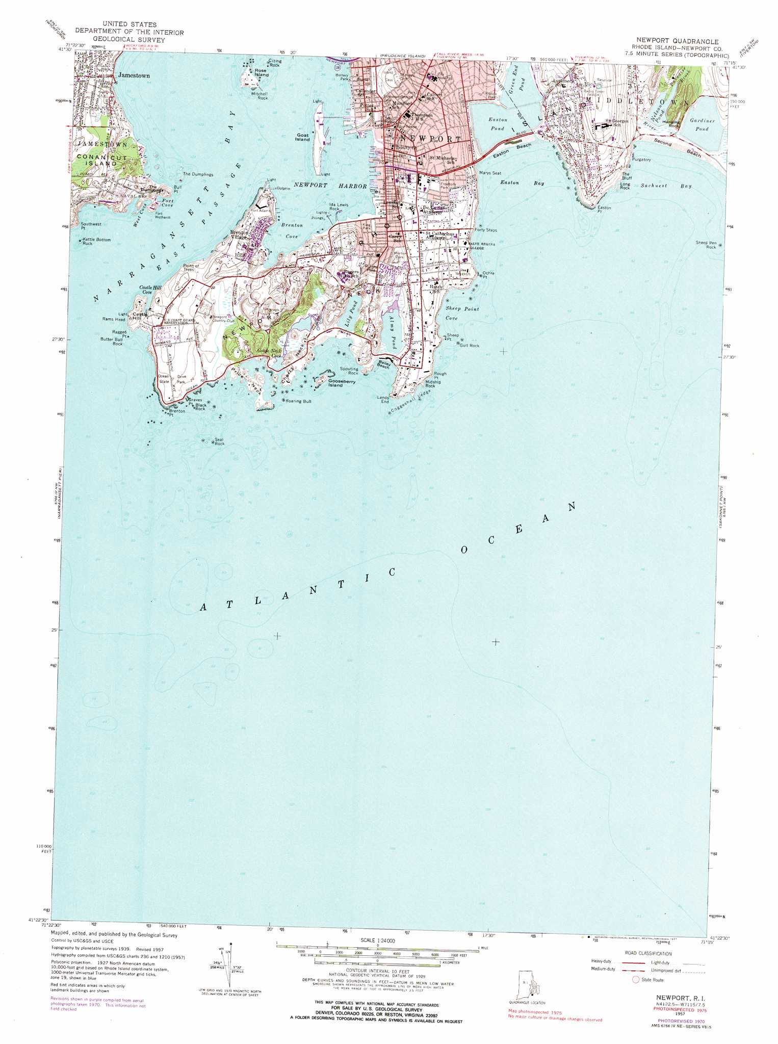
USGS Topo Quad 41071d3 - 1:24,000 scale
| Topo Map Name: | Newport |
| USGS Topo Quad ID: | 41071d3 |
| Print Size: | ca. 21 1/4" wide x 27" high |
| Southeast Coordinates: | 41.375° N latitude / 71.25° W longitude |
| Map Center Coordinates: | 41.4375° N latitude / 71.3125° W longitude |
| U.S. State: | RI |
| Filename: | o41071d3.jpg |
| Download Map JPG Image: | Newport topo map 1:24,000 scale |
| Map Type: | Topographic |
| Topo Series: | 7.5´ |
| Map Scale: | 1:24,000 |
| Source of Map Images: | United States Geological Survey (USGS) |
| Alternate Map Versions: |
Newport RI 1939, updated 1957 Download PDF Buy paper map Newport RI 1957, updated 1959 Download PDF Buy paper map Newport RI 1957, updated 1972 Download PDF Buy paper map Newport RI 1957, updated 1977 Download PDF Buy paper map Newport RI 1957, updated 1977 Download PDF Buy paper map Newport RI 2012 Download PDF Buy paper map Newport RI 2015 Download PDF Buy paper map |
1:24,000 Topo Quads surrounding Newport
Crompton |
East Greenwich |
Bristol |
Fall River East |
|
Slocum |
Wickford |
Prudence Island |
Westport |
|
Kingston |
Narragansett Pier |
Newport |
Sakonnet Point |
|
Block Island |
> Back to 41071a1 at 1:100,000 scale
> Back to 41070a1 at 1:250,000 scale
> Back to U.S. Topo Maps home
Newport topo map: Gazetteer
Newport: Bars
Brenton Reef elevation 0m 0′Haycock Ledge elevation 0m 0′
Seal Ledge elevation 0m 0′
Newport: Bays
Brenton Cove elevation 0m 0′Castle Hill Cove elevation 0m 0′
Concord Gulf Cove elevation 0m 0′
Easton Bay elevation 0m 0′
Fort Cove elevation 0m 0′
Goose Neck Cove elevation 1m 3′
Newport Harbor elevation 0m 0′
Sachuest Bay elevation 0m 0′
Sand Beach Cove elevation 0m 0′
Sheep Point Cove elevation 0m 0′
West Cove elevation 0m 0′
Newport: Beaches
Atlantic Beach elevation 0m 0′Bailey Beach elevation 0m 0′
Collins Beach elevation 0m 0′
Easton Beach elevation 0m 0′
Gooseberry Beach elevation 1m 3′
Hazard Beach elevation 0m 0′
King Park Beach elevation 0m 0′
Old Salt Work Beach elevation 8m 26′
Newport: Benches
Coggeshall Ledge elevation 0m 0′Elbow Ledge elevation 0m 0′
Newport: Capes
Brenton Point elevation 0m 0′Bull Point elevation 0m 0′
Castle Hill elevation 4m 13′
Cherry Neck elevation 6m 19′
Dyer Point elevation 0m 0′
Easton Point elevation 0m 0′
Goose Neck elevation 2m 6′
Graves Point elevation 0m 0′
Lands End elevation 0m 0′
Newport Neck elevation 5m 16′
Ochre Point elevation 0m 0′
Point of Trees elevation 2m 6′
Price Neck elevation 4m 13′
Ragged Point elevation 10m 32′
Rough Point elevation 0m 0′
Sheep Point elevation 2m 6′
Southwest Point elevation 1m 3′
Newport: Cliffs
Forty Steps elevation 0m 0′Marys Seat elevation 0m 0′
Rams Head elevation 0m 0′
The Bluff elevation 2m 6′
Newport: Dams
Easton Pond South Dam elevation 0m 0′Gardiner Pond Dam elevation 0m 0′
Green End Pond Dam elevation 0m 0′
Nelson Pond Dam elevation 0m 0′
Newport: Islands
Goat Island elevation 2m 6′Gooseberry Island elevation 2m 6′
Rose Island elevation 0m 0′
Newport: Lakes
Almy Pond elevation 0m 0′Boat House Gully elevation 7m 22′
Lily Pond elevation 0m 0′
Newport: Parks
Bellevue Avenue Historic District elevation 15m 49′Bellevue Avenue-Casino Historic District elevation 25m 82′
Brick Market Place elevation 2m 6′
Cardines Field elevation 0m 0′
Eisenhower Park elevation 4m 13′
Fort Adams State Park elevation 1m 3′
Fort Wetherill State Park elevation 19m 62′
Freebody Park elevation 17m 55′
Hunter Playfield elevation 0m 0′
J Paul Braga Junior Memorial Field elevation 3m 9′
Kay Street-Catherine Street-Old Beach Road Historic District elevation 3m 9′
King Park elevation 0m 0′
Long Wharf Mill elevation 0m 0′
Morton Park elevation 12m 39′
Murphy Field elevation 11m 36′
Newport Historic District elevation 7m 22′
Norman Bird Sanctuary elevation 7m 22′
Ocean Drive Historic District elevation 0m 0′
Ocean Drive State Park elevation 12m 39′
Ochre Point-Cliffs Historic District elevation 13m 42′
Queen Ann Square elevation 0m 0′
Queen Anne Square elevation 4m 13′
Rochambeau Statue and Monument elevation 0m 0′
Storer Park elevation 0m 0′
Touro Park elevation 26m 85′
Washington Square elevation 7m 22′
Newport: Pillars
Beach Rock elevation 0m 0′Black Rock elevation 0m 0′
Butter Ball Rock elevation 0m 0′
Citing Rock elevation 0m 0′
Ellison Rock elevation 0m 0′
Gull Rock elevation 0m 0′
Hanging Rock elevation 7m 22′
Ida Lewis Rock elevation 0m 0′
Kettle Bottom Rock elevation 0m 0′
Long Rock elevation 0m 0′
Midship Rock elevation 0m 0′
Mitchell Rock elevation 0m 0′
Purgatory elevation 0m 0′
Roaring Bull elevation 0m 0′
Seal Rock elevation 0m 0′
Sheep Pen Rock elevation 0m 0′
Spouting Rock elevation 0m 0′
Supp Rock elevation 0m 0′
Newport: Populated Places
Brenton Village elevation 7m 22′Jamestown elevation 1m 3′
Newport elevation 9m 29′
Purgatory elevation 21m 68′
Newport: Post Offices
Broadway Post Office elevation 14m 45′Newport Post Office elevation 4m 13′
Newport: Reservoirs
Easton Pond elevation 0m 0′Gardiner Pond elevation 0m 0′
Green End Pond elevation 0m 0′
Nelson Pond elevation 0m 0′
Newport: Streams
Maiford River elevation 0m 0′Paradise Brook elevation 2m 6′
Newport: Summits
Castle Hill elevation 0m 0′Fort Wetherill elevation 0m 0′
The Dumplings elevation 8m 26′
Newport digital topo map on disk
Buy this Newport topo map showing relief, roads, GPS coordinates and other geographical features, as a high-resolution digital map file on DVD:
Maine, New Hampshire, Rhode Island & Eastern Massachusetts
Buy digital topo maps: Maine, New Hampshire, Rhode Island & Eastern Massachusetts