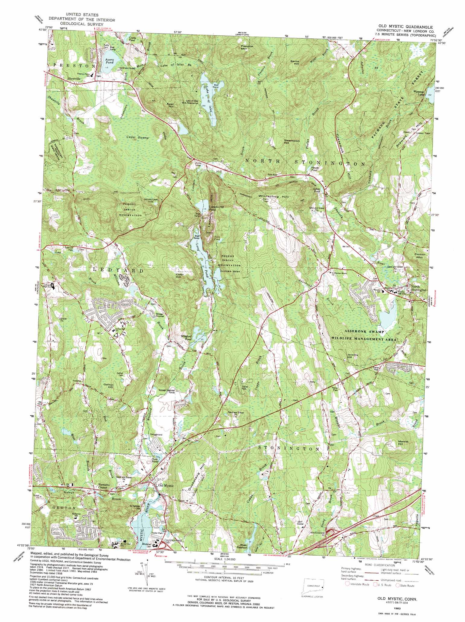
Old Mystic Topo Map Connecticut
To zoom in, hover over the map of Old Mystic
USGS Topo Quad 41071d8 - 1:24,000 scale
| Topo Map Name: | Old Mystic |
| USGS Topo Quad ID: | 41071d8 |
| Print Size: | ca. 21 1/4" wide x 27" high |
| Southeast Coordinates: | 41.375° N latitude / 71.875° W longitude |
| Map Center Coordinates: | 41.4375° N latitude / 71.9375° W longitude |
| U.S. State: | CT |
| Filename: | o41071d8.jpg |
| Download Map JPG Image: | Old Mystic topo map 1:24,000 scale |
| Map Type: | Topographic |
| Topo Series: | 7.5´ |
| Map Scale: | 1:24,000 |
| Source of Map Images: | United States Geological Survey (USGS) |
| Alternate Map Versions: |
Old Mystic CT 1958, updated 1959 Download PDF Buy paper map Old Mystic CT 1958, updated 1971 Download PDF Buy paper map Old Mystic CT 1983, updated 1984 Download PDF Buy paper map Old Mystic CT 1983, updated 1984 Download PDF Buy paper map Old Mystic CT 1983, updated 1984 Download PDF Buy paper map Old Mystic CT 2012 Download PDF Buy paper map Old Mystic CT 2015 Download PDF Buy paper map |
1:24,000 Topo Quads surrounding Old Mystic
Willimantic |
Scotland |
Plainfield |
Oneco |
Coventry Center |
Fitchville |
Norwich |
Jewett City |
Voluntown |
Hope Valley |
Montville |
Uncasville |
Old Mystic |
Ashaway |
Carolina |
Niantic |
New London |
Mystic |
Watch Hill |
Quonochontaug |
Plum Island |
> Back to 41071a1 at 1:100,000 scale
> Back to 41070a1 at 1:250,000 scale
> Back to U.S. Topo Maps home
Old Mystic topo map: Gazetteer
Old Mystic: Airports
Wychwood Field elevation 92m 301′Old Mystic: Dams
Lake of Isles Dam elevation 78m 255′Long Pond Dam elevation 28m 91′
Tribrook Pond Dam elevation 48m 157′
Whitford Pond Dam elevation 21m 68′
Old Mystic: Lakes
Avery Pond elevation 35m 114′Cooks Pond elevation 48m 157′
Gallup Pond elevation 63m 206′
Hewitt Pond elevation 61m 200′
Hyde Pond elevation 6m 19′
Lake Of Isles elevation 77m 252′
Lantern Hill Pond elevation 35m 114′
Long Pond elevation 28m 91′
Silex Pond elevation 62m 203′
Whitford Pond elevation 21m 68′
Old Mystic: Parks
Assekonk Swamp State Wildlife Management Area elevation 43m 141′Avon Park elevation 59m 193′
Corey Sub Park elevation 57m 187′
Fieldcrest Park elevation 60m 196′
Highland Lake Park elevation 25m 82′
Lozier Sub Park elevation 34m 111′
Mystic Carousel and Fun Center elevation 10m 32′
North Stonington Town Recreation Area elevation 56m 183′
North Stonington Village Historic District elevation 43m 141′
River Road Park elevation 21m 68′
Shady Oaks Park elevation 22m 72′
Old Mystic: Populated Places
Burnetts Corner elevation 19m 62′North Stonington elevation 43m 141′
Old Mystic elevation 4m 13′
Shewville elevation 54m 177′
Old Mystic: Post Offices
North Stonington Post Office elevation 49m 160′Old Mystic Post Office (historical) elevation 1m 3′
Old Mystic: Reservoirs
Lake of Isles elevation 78m 255′Lords Pond elevation 56m 183′
Tribrook Pond elevation 48m 157′
Old Mystic: Streams
Assekonk Brook elevation 43m 141′Haleys Brook elevation 5m 16′
Hill Brook elevation 59m 193′
Indiantown Brook elevation 40m 131′
Lake of Isles Brook elevation 45m 147′
Lantern Brook elevation 35m 114′
Lee Brook elevation 30m 98′
Main Brook elevation 35m 114′
Phelps Brook elevation 69m 226′
Red Brook elevation 11m 36′
West Branch Red Brook elevation 14m 45′
Wheeler Brook elevation 27m 88′
Whitford Brook elevation 6m 19′
Williams Brook elevation 23m 75′
Yawbucs Brook elevation 47m 154′
Old Mystic: Summits
Ayer Hill elevation 144m 472′Barns Hill elevation 151m 495′
Barns Hill elevation 155m 508′
Cider Hill elevation 90m 295′
Cossaduck Hill elevation 139m 456′
Gallup Hill elevation 79m 259′
Jeremy Hill elevation 101m 331′
Lantern Hill elevation 118m 387′
Merritt Hill elevation 71m 232′
Pitcher Mountain elevation 95m 311′
Prentice Mountain elevation 163m 534′
Pumpkin Hill elevation 96m 314′
Quoketaug Hill elevation 66m 216′
Stewart Hill elevation 149m 488′
Swantown Hill elevation 132m 433′
Wintechog Hill elevation 139m 456′
Old Mystic: Swamps
Assekonk Swamp elevation 43m 141′Cedar Swamp elevation 51m 167′
Old Mystic: Trails
Narragansett Trail elevation 125m 410′Old Mystic digital topo map on disk
Buy this Old Mystic topo map showing relief, roads, GPS coordinates and other geographical features, as a high-resolution digital map file on DVD:
Maine, New Hampshire, Rhode Island & Eastern Massachusetts
Buy digital topo maps: Maine, New Hampshire, Rhode Island & Eastern Massachusetts