Coventry Center Topo Map Rhode Island
To zoom in, hover over the map of Coventry Center
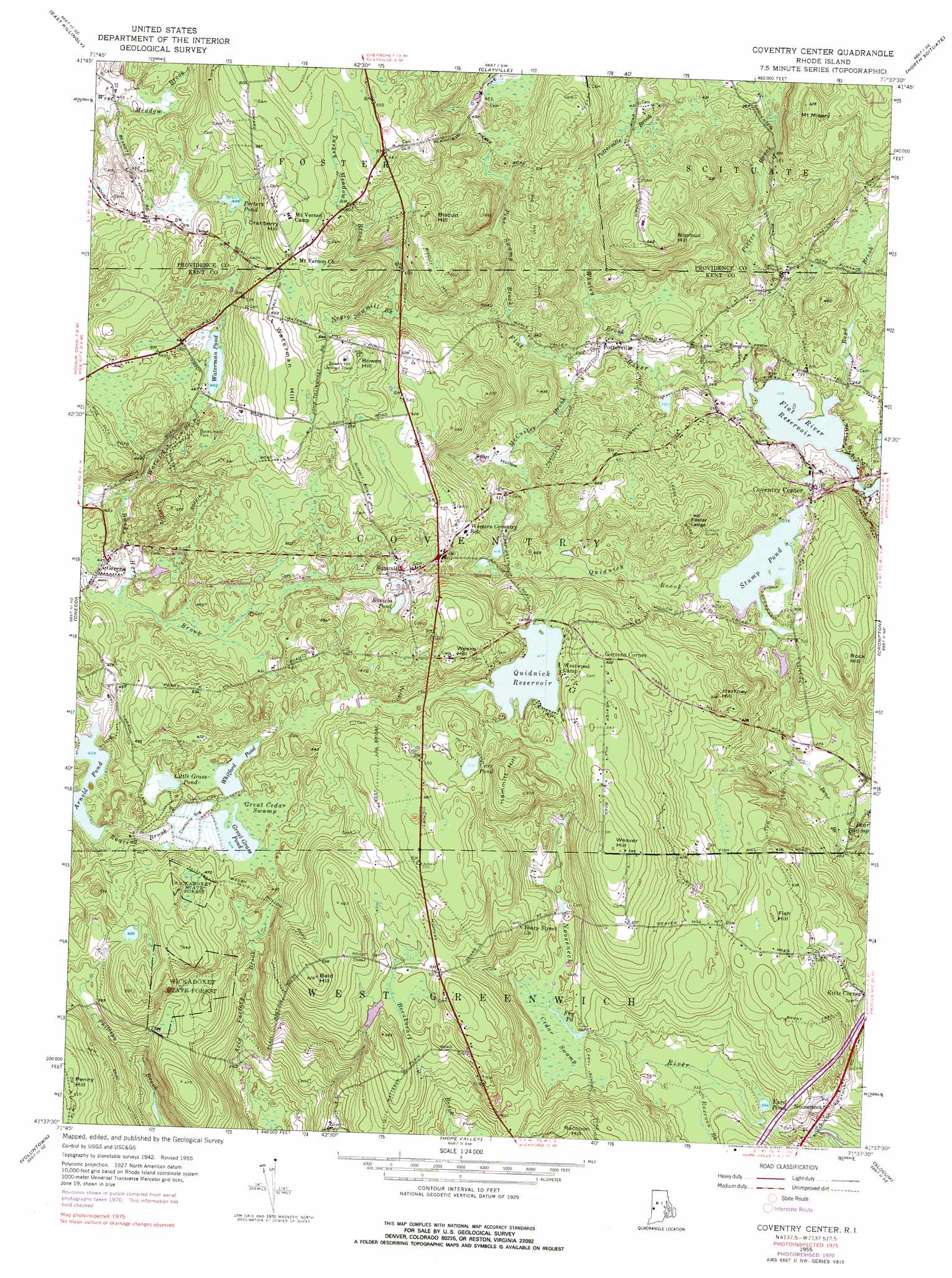
USGS Topo Quad 41071f6 - 1:24,000 scale
| Topo Map Name: | Coventry Center |
| USGS Topo Quad ID: | 41071f6 |
| Print Size: | ca. 21 1/4" wide x 27" high |
| Southeast Coordinates: | 41.625° N latitude / 71.625° W longitude |
| Map Center Coordinates: | 41.6875° N latitude / 71.6875° W longitude |
| U.S. State: | RI |
| Filename: | o41071f6.jpg |
| Download Map JPG Image: | Coventry Center topo map 1:24,000 scale |
| Map Type: | Topographic |
| Topo Series: | 7.5´ |
| Map Scale: | 1:24,000 |
| Source of Map Images: | United States Geological Survey (USGS) |
| Alternate Map Versions: |
Coventry Center RI 1955, updated 1957 Download PDF Buy paper map Coventry Center RI 1955, updated 1965 Download PDF Buy paper map Coventry Center RI 1955, updated 1972 Download PDF Buy paper map Coventry Center RI 1955, updated 1977 Download PDF Buy paper map Coventry Center RI 1955, updated 1977 Download PDF Buy paper map Coventry Center RI 2012 Download PDF Buy paper map Coventry Center RI 2015 Download PDF Buy paper map |
1:24,000 Topo Quads surrounding Coventry Center
Putnam |
Thompson |
Chepachet |
Georgiaville |
|
Danielson |
East Killingly |
Clayville |
North Scituate |
|
Plainfield |
Oneco |
Coventry Center |
Crompton |
East Greenwich |
Jewett City |
Voluntown |
Hope Valley |
Slocum |
Wickford |
Old Mystic |
Ashaway |
Carolina |
Kingston |
Narragansett Pier |
> Back to 41071e1 at 1:100,000 scale
> Back to 41070a1 at 1:250,000 scale
> Back to U.S. Topo Maps home
Coventry Center topo map: Gazetteer
Coventry Center: Airports
Keskinen Airport elevation 77m 252′Coventry Center: Benches
Foster Ledge elevation 149m 488′Coventry Center: Dams
Coventry Reservoir Dam elevation 97m 318′Quidnick Reservoir Dam elevation 145m 475′
Waterman Pond Dam elevation 140m 459′
Coventry Center: Forests
Wickaboxet State Forest elevation 140m 459′Coventry Center: Lakes
Carr Pond elevation 160m 524′Fry Pond elevation 117m 383′
Great Grass Pond elevation 132m 433′
Koszela Pond elevation 146m 479′
Little Grass Pond elevation 136m 446′
Porters Pond elevation 149m 488′
Waterman Pond elevation 140m 459′
Yard Pond elevation 113m 370′
Coventry Center: Mines
Jackson Quarry elevation 121m 396′Coventry Center: Parks
Audubon Society George B Parker Woodland elevation 140m 459′Bucks Horn Park elevation 156m 511′
Coventry Center: Populated Places
Coventry elevation 129m 423′Gortons Corner elevation 165m 541′
Greene elevation 130m 426′
Potterville elevation 93m 305′
Vernon elevation 188m 616′
Coventry Center: Reservoirs
Arnold Pond elevation 123m 403′Coventry Reservoir elevation 97m 318′
Quidnick Reservoir elevation 145m 475′
Stump Pond elevation 92m 301′
Whitford Pond elevation 133m 436′
Coventry Center: Streams
Boyd Brook elevation 77m 252′Flat River elevation 74m 242′
McCuster Brook elevation 91m 298′
Negro Sawmill Brook elevation 141m 462′
Pierce Brook elevation 76m 249′
Pine Swamp Brook elevation 107m 351′
Quidnick Brook elevation 92m 301′
Raccoon Brook elevation 106m 347′
Turkey Meadow Brook elevation 159m 521′
Warwick Brook elevation 140m 459′
Whaley Brook elevation 89m 291′
Coventry Center: Summits
Bald Hill elevation 203m 666′Biscuit Hill elevation 180m 590′
Bowen Hill elevation 184m 603′
Cranberry Hill elevation 189m 620′
Hammitt Hill elevation 187m 613′
Harkney Hill elevation 150m 492′
Mount Misery elevation 154m 505′
Nipmuc Hill elevation 181m 593′
Penny Hill elevation 159m 521′
Rock Hill elevation 131m 429′
Waterman Hill elevation 174m 570′
Weaver Hill elevation 184m 603′
Weeks Hill elevation 181m 593′
Coventry Center: Swamps
Bear Swamp elevation 77m 252′Cedar Swamp elevation 121m 396′
Fish Hill elevation 144m 472′
Great Cedar Swamp elevation 134m 439′
Coventry Center: Valleys
Scott Hollow elevation 113m 370′Coventry Center digital topo map on disk
Buy this Coventry Center topo map showing relief, roads, GPS coordinates and other geographical features, as a high-resolution digital map file on DVD:
Maine, New Hampshire, Rhode Island & Eastern Massachusetts
Buy digital topo maps: Maine, New Hampshire, Rhode Island & Eastern Massachusetts