Oneco Topo Map Connecticut
To zoom in, hover over the map of Oneco
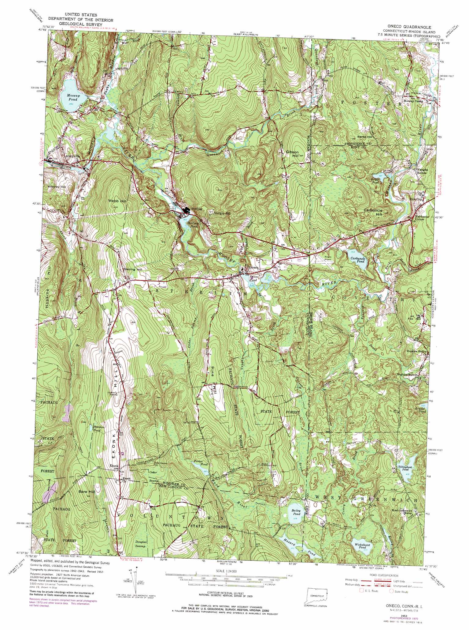
USGS Topo Quad 41071f7 - 1:24,000 scale
| Topo Map Name: | Oneco |
| USGS Topo Quad ID: | 41071f7 |
| Print Size: | ca. 21 1/4" wide x 27" high |
| Southeast Coordinates: | 41.625° N latitude / 71.75° W longitude |
| Map Center Coordinates: | 41.6875° N latitude / 71.8125° W longitude |
| U.S. States: | CT, RI |
| Filename: | o41071f7.jpg |
| Download Map JPG Image: | Oneco topo map 1:24,000 scale |
| Map Type: | Topographic |
| Topo Series: | 7.5´ |
| Map Scale: | 1:24,000 |
| Source of Map Images: | United States Geological Survey (USGS) |
| Alternate Map Versions: |
Oneco CT 1953, updated 1957 Download PDF Buy paper map Oneco CT 1953, updated 1966 Download PDF Buy paper map Oneco CT 1953, updated 1972 Download PDF Buy paper map Oneco CT 1953, updated 1979 Download PDF Buy paper map Oneco CT 2012 Download PDF Buy paper map Oneco CT 2015 Download PDF Buy paper map |
1:24,000 Topo Quads surrounding Oneco
Eastford |
Putnam |
Thompson |
Chepachet |
Georgiaville |
Hampton |
Danielson |
East Killingly |
Clayville |
North Scituate |
Scotland |
Plainfield |
Oneco |
Coventry Center |
Crompton |
Norwich |
Jewett City |
Voluntown |
Hope Valley |
Slocum |
Uncasville |
Old Mystic |
Ashaway |
Carolina |
Kingston |
> Back to 41071e1 at 1:100,000 scale
> Back to 41070a1 at 1:250,000 scale
> Back to U.S. Topo Maps home
Oneco topo map: Gazetteer
Oneco: Airports
Riconn Airport elevation 117m 383′Oneco: Dams
Arnold Pond Dam elevation 111m 364′Brunswick Dam elevation 103m 337′
Gorham Farm Pond Dam elevation 134m 439′
Hell Hollow Pond Dam elevation 113m 370′
Moosup Pond Dam elevation 85m 278′
Oneco Pond Dam elevation 103m 337′
Sterling Pond Dam elevation 92m 301′
Oneco: Lakes
Bailey Pond elevation 100m 328′Bailey Pond elevation 100m 328′
Briggs Pond elevation 121m 396′
Carbuncle Pond elevation 104m 341′
Hazard Pond elevation 99m 324′
Hazard Pond elevation 99m 324′
Moosup Pond elevation 85m 278′
Porter Pond elevation 110m 360′
Stanton Pond elevation 169m 554′
Tillinghast Pond elevation 127m 416′
Wickaboxet Pond elevation 100m 328′
Oneco: Parks
Carbuncle Pond Management Area elevation 104m 341′Mooseup Valley Historic District elevation 133m 436′
Nicholas Farm Management Area elevation 120m 393′
Rice City Historical District elevation 151m 495′
Sterling Hill Historic District elevation 186m 610′
Oneco: Populated Places
Almyville elevation 87m 285′Ekonk elevation 195m 639′
Fairbanks Corner elevation 132m 433′
Hopkins Hollow elevation 110m 360′
Moosup Valley elevation 148m 485′
Oneco elevation 105m 344′
Rice City elevation 152m 498′
Sterling elevation 91m 298′
Vaughn Hollow elevation 132m 433′
Oneco: Post Offices
Oneco Post Office elevation 115m 377′Sterling Post Office elevation 90m 295′
Oneco: Reservoirs
Gorham Farm Pond elevation 134m 439′Hell Hollow Pond elevation 113m 370′
Oneco Pond elevation 103m 337′
Roger Lake elevation 84m 275′
Sterling Pond elevation 92m 301′
Oneco: Streams
Browns Brook elevation 98m 321′Bucks Horn Brook elevation 108m 354′
Carson Brook elevation 97m 318′
Cedar Swamp Brook elevation 102m 334′
Coney Brook elevation 107m 351′
Crooked Brook elevation 106m 347′
Dixon Brook elevation 126m 413′
Quanduck Brook elevation 91m 298′
Roaring Brook elevation 110m 360′
Snake Meadow Brook elevation 83m 272′
Tyler Brook elevation 91m 298′
Vaughn Brook elevation 103m 337′
West Meadow Brook elevation 126m 413′
Wood Brook elevation 124m 406′
Oneco: Summits
Barbs Hill elevation 170m 557′Bare Hill elevation 193m 633′
Carbuncle Hill elevation 148m 485′
Ekonk Hill elevation 204m 669′
Fox Hill elevation 153m 501′
Gibson Hill elevation 189m 620′
Hopkins Hill elevation 146m 479′
Pine Hill elevation 186m 610′
Sterling Hill elevation 187m 613′
Webb Hill elevation 171m 561′
Withey Hill elevation 126m 413′
Oneco: Swamps
Cedar Swamp elevation 151m 495′Douglas Swamp elevation 151m 495′
Lockes Meadow (historical) elevation 146m 479′
Oneco: Valleys
Hell Hollow elevation 105m 344′Oneco digital topo map on disk
Buy this Oneco topo map showing relief, roads, GPS coordinates and other geographical features, as a high-resolution digital map file on DVD:
Maine, New Hampshire, Rhode Island & Eastern Massachusetts
Buy digital topo maps: Maine, New Hampshire, Rhode Island & Eastern Massachusetts