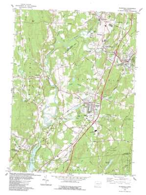
Plainfield Topo Map Connecticut
To zoom in, hover over the map of Plainfield
USGS Topo Quad 41071f8 - 1:24,000 scale
| Topo Map Name: | Plainfield |
| USGS Topo Quad ID: | 41071f8 |
| Print Size: | ca. 21 1/4" wide x 27" high |
| Southeast Coordinates: | 41.625° N latitude / 71.875° W longitude |
| Map Center Coordinates: | 41.6875° N latitude / 71.9375° W longitude |
| U.S. State: | CT |
| Filename: | o41071f8.jpg |
| Download Map JPG Image: | Plainfield topo map 1:24,000 scale |
| Map Type: | Topographic |
| Topo Series: | 7.5´ |
| Map Scale: | 1:24,000 |
| Source of Map Images: | United States Geological Survey (USGS) |
| Alternate Map Versions: |
Plainfield CT 1953, updated 1959 Download PDF Buy paper map Plainfield CT 1953, updated 1960 Download PDF Buy paper map Plainfield CT 1953, updated 1968 Download PDF Buy paper map Plainfield CT 1953, updated 1971 Download PDF Buy paper map Plainfield CT 1983, updated 1983 Download PDF Buy paper map Plainfield CT 1983, updated 1983 Download PDF Buy paper map Plainfield CT 1983, updated 1983 Download PDF Buy paper map Plainfield CT 2012 Download PDF Buy paper map Plainfield CT 2015 Download PDF Buy paper map |
1:24,000 Topo Quads surrounding Plainfield
> Back to 41071e1 at 1:100,000 scale
> Back to 41070a1 at 1:250,000 scale
> Back to U.S. Topo Maps home
Plainfield topo map: Gazetteer
Plainfield: Bridges
Butts Bridge elevation 27m 88′Canterbury Bridge elevation 43m 141′
Pierce Bridge elevation 40m 131′
Plainfield: Dams
Packers Pond Dam elevation 49m 160′Stone Hill Reservoir Dam elevation 126m 413′
Plainfield: Islands
Peagscomsuck Island elevation 27m 88′Plainfield: Lakes
Evans Pond elevation 56m 183′Plainfield: Parks
Canterbury Green elevation 78m 255′Plainfield Street Historic District elevation 53m 173′
Rams Athletic Field elevation 50m 164′
Wauregan Historic District elevation 42m 137′
Plainfield: Populated Places
Canterbury elevation 78m 255′Central Village elevation 59m 193′
Moosup elevation 72m 236′
Packer elevation 42m 137′
Plainfield elevation 60m 196′
Wauregan elevation 59m 193′
Wauregan Station elevation 63m 206′
West Wauregan elevation 41m 134′
Plainfield: Post Offices
Canterbury Post Office elevation 74m 242′Moosup Post Office elevation 73m 239′
Wauregan Post Office elevation 44m 144′
Plainfield: Reservoirs
Bennett Pond elevation 66m 216′Burr Smith Pond elevation 60m 196′
Frank Bennett Pond elevation 79m 259′
Packers Pond elevation 49m 160′
Stone Hill Reservoir elevation 126m 413′
Plainfield: Streams
Angell Brook elevation 51m 167′Apple Tree Meadow Brook elevation 57m 187′
Bennett Brook elevation 84m 275′
Blackwell Brook elevation 38m 124′
Cold Spring Brook elevation 42m 137′
Cone Brook elevation 28m 91′
Cory Brook elevation 27m 88′
Darby Brook elevation 40m 131′
Ekonk Brook elevation 75m 246′
Havey Brook elevation 58m 190′
Horse Brook elevation 51m 167′
Kitt Brook elevation 36m 118′
Lathrop Brook elevation 46m 150′
Mill Brook elevation 27m 88′
Moosup River elevation 46m 150′
Mudhole Brook elevation 47m 154′
Palmer Brook elevation 41m 134′
Reservoir Brook elevation 54m 177′
Sugar Brook elevation 42m 137′
Tatnic Brook elevation 39m 127′
Plainfield: Summits
Black Hill elevation 110m 360′Buck Hill elevation 144m 472′
Holmes Hill elevation 144m 472′
Morgan Hill elevation 156m 511′
North Hill elevation 144m 472′
Shepherd Hill elevation 99m 324′
Plainfield: Swamps
Cedar Swamp elevation 53m 173′Plainfield digital topo map on disk
Buy this Plainfield topo map showing relief, roads, GPS coordinates and other geographical features, as a high-resolution digital map file on DVD:
Maine, New Hampshire, Rhode Island & Eastern Massachusetts
Buy digital topo maps: Maine, New Hampshire, Rhode Island & Eastern Massachusetts


