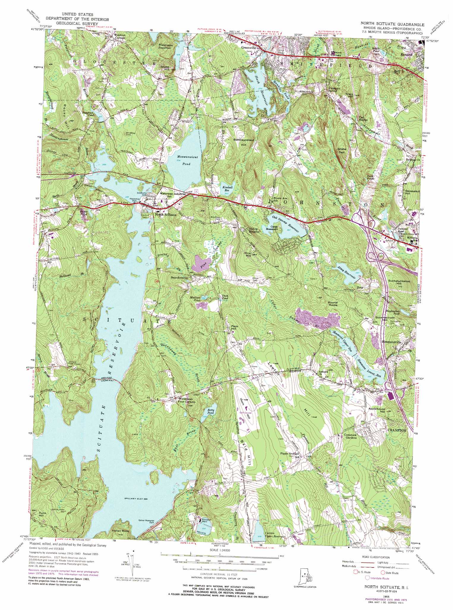
North Scituate Topo Map Rhode Island
To zoom in, hover over the map of North Scituate
USGS Topo Quad 41071g5 - 1:24,000 scale
| Topo Map Name: | North Scituate |
| USGS Topo Quad ID: | 41071g5 |
| Print Size: | ca. 21 1/4" wide x 27" high |
| Southeast Coordinates: | 41.75° N latitude / 71.5° W longitude |
| Map Center Coordinates: | 41.8125° N latitude / 71.5625° W longitude |
| U.S. State: | RI |
| Filename: | o41071g5.jpg |
| Download Map JPG Image: | North Scituate topo map 1:24,000 scale |
| Map Type: | Topographic |
| Topo Series: | 7.5´ |
| Map Scale: | 1:24,000 |
| Source of Map Images: | United States Geological Survey (USGS) |
| Alternate Map Versions: |
North Scituate RI 1955, updated 1958 Download PDF Buy paper map North Scituate RI 1955, updated 1973 Download PDF Buy paper map North Scituate RI 1955, updated 1976 Download PDF Buy paper map North Scituate RI 1975, updated 1988 Download PDF Buy paper map North Scituate RI 1996, updated 2000 Download PDF Buy paper map North Scituate RI 2012 Download PDF Buy paper map North Scituate RI 2015 Download PDF Buy paper map |
1:24,000 Topo Quads surrounding North Scituate
Oxford |
Blackstone |
Wrentham |
||
Thompson |
Chepachet |
Georgiaville |
Attleboro |
|
East Killingly |
Clayville |
North Scituate |
East Providence |
|
Oneco |
Coventry Center |
Crompton |
East Greenwich |
Bristol |
Voluntown |
Hope Valley |
Slocum |
Wickford |
Prudence Island |
> Back to 41071e1 at 1:100,000 scale
> Back to 41070a1 at 1:250,000 scale
> Back to U.S. Topo Maps home
North Scituate topo map: Gazetteer
North Scituate: Beaches
Slacks Pond Beach elevation 90m 295′North Scituate: Crossings
Interchange 4 elevation 98m 321′Interchange 5 elevation 105m 344′
Interchange 5A elevation 87m 285′
Interchange 5B elevation 79m 259′
Interchange 6 elevation 68m 223′
Interchange 7 elevation 71m 232′
Interchange 7A elevation 72m 236′
Interchange 7B elevation 65m 213′
North Scituate: Dams
Almy Reservoir Dam elevation 87m 285′Curran Upper Reservoir Dam elevation 106m 347′
Gainer Memorial Dam elevation 85m 278′
Hawkins Pond Dam elevation 82m 269′
Horseshoe Dam elevation 86m 282′
Kimball Reservoir Dam elevation 105m 344′
Moswansicut Pond Dam elevation 93m 305′
Oak Swamp Reservoir Dam elevation 110m 360′
Simmons Lower Reservoir Dam elevation 87m 285′
Simmons Upper Reservoir Dam elevation 89m 291′
Slack Reservoir Dam elevation 86m 282′
North Scituate: Lakes
Dexter Pond elevation 118m 387′Duck Ponds elevation 95m 311′
Hawkins Pond elevation 82m 269′
Madison Pond elevation 130m 426′
Moswansicut Pond elevation 93m 305′
Pocasset Pond elevation 39m 127′
Sebille Pond elevation 57m 187′
North Scituate: Parks
Johnston Memorial Park elevation 50m 164′Powder Mill Ledges Wildlife Refuge elevation 101m 331′
Smithville-North Scituate Historic District elevation 97m 318′
North Scituate: Pillars
Indian Rock elevation 123m 403′North Scituate: Populated Places
Ashland (historical) elevation 87m 285′Bishop Heights elevation 152m 498′
Comstock Gardens elevation 128m 419′
Elmdale (historical) elevation 91m 298′
Fountain Spring elevation 91m 298′
Greenville elevation 87m 285′
Harrisdale elevation 100m 328′
Kent (historical) elevation 87m 285′
North Scituate elevation 93m 305′
Richmond (historical) elevation 87m 285′
Saundersville elevation 117m 383′
Simmonsville elevation 79m 259′
South Scituate (historical) elevation 87m 285′
Waldron Corners elevation 145m 475′
North Scituate: Post Offices
Greenville Post Office elevation 90m 295′North Scituate Post Office elevation 94m 308′
North Scituate: Reservoirs
Almy Reservoir elevation 87m 285′Betty Pond elevation 94m 308′
Curran Upper Reservoir elevation 106m 347′
Duck Pond elevation 140m 459′
Hughesdale Pond elevation 69m 226′
John L Curran Upper Reservoir elevation 98m 321′
Kimball Reservoir elevation 105m 344′
Oak Swamp Reservoir elevation 110m 360′
Peeptoad Pond elevation 96m 314′
Pine Swamp Reservoir elevation 117m 383′
Scituate Reservoir elevation 85m 278′
Simmons Lower Reservoir elevation 87m 285′
Simmons Upper Reservoir elevation 89m 291′
Slack Reservoir elevation 86m 282′
North Scituate: Streams
Brandy Brook elevation 86m 282′Bullhead Brook elevation 89m 291′
Cedar Swamp Brook elevation 87m 285′
Hawkins Brook elevation 37m 121′
Huntinghouse Brook elevation 88m 288′
Kent Brook elevation 87m 285′
Peeptoad Brook elevation 98m 321′
Quonopaug Brook elevation 93m 305′
Rush Brook elevation 90m 295′
Soakhide Brook elevation 114m 374′
Spruce Brook elevation 92m 301′
North Scituate: Summits
Applehouse Hill elevation 113m 370′Bald Hill elevation 161m 528′
Bare Rock elevation 79m 259′
Cat Rocks elevation 95m 311′
Horn Hill elevation 154m 505′
Lawton Hill elevation 141m 462′
Peck Hill elevation 167m 547′
Pine Hill elevation 174m 570′
Rocky Hill elevation 147m 482′
Round Rocks elevation 116m 380′
Secesakut Hill elevation 105m 344′
Sickkibunkiaut Hill elevation 137m 449′
Snake Den elevation 120m 393′
Snake Hill elevation 144m 472′
Suckatunkanuc Hill elevation 111m 364′
Sutamachute Hill elevation 111m 364′
Tracy Hill elevation 131m 429′
Tunk Hill elevation 174m 570′
North Scituate: Swamps
Pine Swamp elevation 116m 380′North Scituate digital topo map on disk
Buy this North Scituate topo map showing relief, roads, GPS coordinates and other geographical features, as a high-resolution digital map file on DVD:
Maine, New Hampshire, Rhode Island & Eastern Massachusetts
Buy digital topo maps: Maine, New Hampshire, Rhode Island & Eastern Massachusetts